Who What Where WhenREMOVEWHO
|
Author
G.W. & C.B. Colton & Co.
Full Title
Maps showing the Indiana & Illinois Central Railway. And Its Connections. Prepared By G.W. & C.B. Colton & Co. 172 William Street New York. Entered ... 1872 by G.W. & C.B. Colton & Co. ... Washington. (with) Untitled inset map of railway connections from the Eastern Seaboard to Colorado and Wyoming.
Publisher
G.W. & C.B. Colton
Author
Cram, George
Full Title
Railroad Map Of Iowa Prepared For The Board Of Railroad Commissioners. By George F. Cram, Map Publisher, 66 Lake Street, Chicago, Ill. Entered ... 1872, by Geo. F. Cram ... Washington.
Publisher
George F. Cram
Author
Hotchkiss, Jedidiah
Full Title
Virginia Hot Springs Company Map Of The Warm Springs Valley Showing Railways, Roads, And Paths Leading To The Healing, Hot And Warm Springs Compiled from U.S. Geol. Survey and other Maps. Eng. Office of Jed. Hotchkiss, Staunton, Va. 1895. With Revisions, 1903. The Norris Peters Co. Photo-Litho., Washington, D.C. (inset map) Virginia Hot Springs and Vicinity. (inset geological section) Section on Line A-B of Map.
Publisher
The Norris Peters Co. Photo Litho.
Author
Palmer, William. J.
Full Title
Map Of The Route Of The Southern Continental R.R. With Connections From Kansas City Mo. Ft. Smith Ark. And Shreveport La. Giving a general View of the Recent Surveys of the Kansas Pacific Railway Co, across the Continent Made in 1867 & 1868 under the direction of Gen. Wm. J. Palmer. On the routes of the 32nd and 35th Parallels. J.F Gedney Lith, Washington, D.C.
Publisher
J.F. Gedney Lith.
Author
Florida East Coast Railway
Full Title
Map of the Peninsula of Florida and Adjacent Islands. Published by the Land Department, Florida East Coast Railway. This map is absolutely correct in all the Geographical details, and every Railroad is shown in its proper location. The Matthews Northrup Co., Complete Engraving And Printing Works, Buffalo, N.Y. (inset) West Indies, Central America And South America. (inset) Bahama Islands
Publisher
Matthews-Northrup Co.
Author
Northwestern Pacific Railroad
Full Title
Northwestern Pacific. Northwestern Pacific Railroad. (Untitled map of Northern California).
Publisher
No publisher
Author
Gensoul, A.
Full Title
Railroad Map Of The City Of San Francisco California. Published By A. Gensoul Pacific Map Depot 511 Montgomery St. S. Franco. 1866. Lith. Britton & Co. S.F.
Publisher
A. Gensoul
Author
Palmer, William. J.
Full Title
Map Of The Route Of The Southern Continental R.R. With Connections From Kansas City Mo. Ft. Smith Ark. And Shreveport La. Giving a general View of the Recent Surveys of the Kansas Pacific Railway Co, across the Continent Made in 1867 & 1968 under the direction of Gen. Wm. J. Palmer. On the routes of the 32nd and 35th Parallels together with compilations from Keeler's Official Map showing the Central and Northern Routes to the Pacific, and the intermediate topography. J.F Gedney Lith, Washington, D.C.
Publisher
J.F. Gedney Lith.
Author
[Britton & Co., Gensoul, A.]
Full Title
Railroad Map Of The City Of San Francisco California. Printed For The San Francisco Directory By Britton & Co. 1864. Lith. Britton & Co. S.F.
Publisher
Britton & Co.
Author
California Pacific Railroad
Full Title
Map Showing California Pacific Rail Road Extension And California Pacific Rail Road With Their Connections. 1869. Steam Litho. Britton & Rey, S.F.
Publisher
Britton & Rey
Author
Rand McNally and Company
Full Title
Black and White Mileage Map Of The United States. Rand McNally & Company. Chicago. New York. Copyright by Rand McNally & Co., Chicago & New York. Made in U.S.A. (in red) Maps-Atlases. Rand McNally & Company. Map Systems. Map Headquarters, Buffalo, N.Y. 1054 Ellicott Sq. Bldg. Phone Seneca 0236.
Publisher
Rand McNally and Company
Author
California Development Board
Full Title
Geographical, Topographical, State Highway And Railroad Map Of California. Published By California Development Board 1914 ... Copyrighted 1914 California Development Board. Britton & Rey, Lithographers, Inc., S.F. (inset) Land area of California ...
Publisher
California Development Board
Author
[Johnstone, E. McD., Southern Pacific Company]
Full Title
Climatic map of California. Published by the Southern Pacific Company. 1888. Compiled by E. McD. Johnstone, S.P. Co. From map prepared under the direction of Brig. Gen. H.C. Wright, Chief of Eng'rs. U.S.A. Lith H.S. Crocker & Co. S.F. Cal. Entered ... 1887, by the Southern Pacific Company ... Washington....
Publisher
Southern Pacific Company
Author
Rand McNally and Company
Full Title
The Rand-McNally Official Railway Guide Map. Corrected To November 1st, 1877. (inset) Vicinity Of Boston. (inset) Vicinity Of New York And Philadelphia. (on verso) Rand-McNally Official Railway Guide Map of the Territories and the Pacific Coast.
Publisher
Rand McNally and Company
Author
Rand McNally and Company
Full Title
Rand-McNally Official Railway Guide Map of the Territories and the Pacific Coast. (on verso)The Rand-McNally Official Railway Guide Map. Corrected To November 1st, 1877. (inset) Vicinity Of Boston. (inset) Vicinity Of New York And Philadelphia.
Publisher
Rand McNally and Company
Author
Tunis, W.E.
Full Title
Tunis' New Colored Railroad Map Of The United States & Canadas. Revised And Corrected Every Month. William E. Tunis, Bookseller and Stationer, 153 Jefferson Avenue, Detroit, Michigan ... Entered ... 1859, by W.E. Tunis ... New York.
Publisher
W.E. Tunis
Author
[Disturnell, John, Colton, J.H.]
Full Title
Map Of North America From The Latest Authorities Showing the Proposed Railroad Routes from the Atlantic to the Pacific Oceans. J.H. Colton & Co. New York, 1854, for J. Disturnell. Entered ... 1849, by J.H. Colton ... New York.
Publisher
J.H. Colton & Co. for J. Disturnell
Author
Williams, Henry T.
Full Title
Williams' New Trans-Continental Map Of The Pacific R.R. And Routes Of Overland Travel To Colorado, Nebraska, The Black Hills, Utah, Idaho, Nevada, Montana, California And The Pacific Coast. Henry T. Williams, Publisher 46 Beekman St. N.Y. Entered ... 1877 by H.T. Williams ... Washington. Am. Photo-Litho. Co. N.Y. (Osborne's Process.)
Publisher
Henry T. Williams
Author
Chisholm, C.R.
Full Title
Chisholm's Railway Map Of The United States And Canada. Published By C.R. Chisholm & Bros., Railway General News Agents, 162 St. James Street, Montreal. Fisk & Russell, Engravers, New York. (inset) Eastern Part Of Massachusetts.
Publisher
C.R. Chisholm & Bros.
Author
American Photo Lithographic Company
Full Title
The Great Railroad Routes To The Pacific, And Their Connections. 1869. American Photo-Lithographic Company, New York, (Osborne's Process).
Publisher
American Photo Lithographic Company
Author
Rand McNally and Company
Full Title
(Denver and Rio Grande Railroad System). Rand, McNally & Co., Engravers, Chicago. (view) Alabaster Hall. (untitled inset map of the Western States).
Publisher
Rand McNally and Company
Author
Rand McNally and Company
Full Title
Denver and Rio Grande Railroad System. Denver & Rio Grande R.R. Scenic Line Of The World. (untitled inset map of the Western States).
Publisher
Rand McNally
Author
Hutawa, Julius
Full Title
Map Of The State Of Missouri. Showing different Railroad Routes surveyed by the Pacific Railroad Compy. as reported to the Legislature of the State of Missouri in December 1852. Julius Hutawa Lithographer, Second Street, betw. Olive & Pine, St. Louis, Mo.
Publisher
Julius Hutawa
Author
Ellet, Charles
Full Title
Map Of The Western Railroads Tributary To Philadelphia, With Their Rival Lines. Prepared under the direction of Charles Ellet Jr. Civil Engineer, by W. Williams, Map Engraver 5th St. below Chesnut Philaa.
Publisher
W. Williams
Author
Rand McNally and Company
Full Title
New Official Railroad Map Of The United States And Canada. Engraved And Printed By Rand, McNally & Co., Chicago ... 148 To 154 Monroe Street, Chicago. Copyright, 1883, by Rand, McNally & Co., Chicago. (inset) Map Of Atlantic Coast States Engraved On Enlarged Scale. (with 8 additional inset maps).
Publisher
Rand McNally and Company
Author
Colton, G.W. & C.B.
Full Title
Map showing the Route of the Duluth & Winnipeg Railroad And Its Connections. Prepared By G.W. & C.B. Colton & Co. 182 William Street New York. Entered ... 1881 by G.W. & C.B. Colton & Co. ... Washington.
Publisher
G.W. & C.B. colton & Co.
Author
Sweet, S.H.
Full Title
Engineers Map Of The State Of New York Showing Its Division Into Agricultural Groups And The Routes Of Commercial Trafic accompanying T.C. Peters Report Upon The Resources Of The State 1864. Comstock & Cassidy Albany, N.Y. By S.H. Sweet Dep. State Engineer.
Publisher
Comstock & Cassidy
Author
Southern Pacific Company
Full Title
Map of California compiled from latest official & authentic information, by the Southern Pacific Company. (8th. edn. 1901)
Publisher
Southern Pacific Company
Author
Anderson, P.
Full Title
Map Exhibiting The Experimental and Located Lines for the New-York and New-Haven Rail-Road ... Projected and Drawn by P. Anderson Civil Engr. Scale 1 to 20,000. Feb. 1845.
Publisher
Manuscript
Author
Rand McNally and Company
Full Title
American Railroads (Class I).
Publisher
Association of American Railroads
Author
Warren, Gouverneur Kemble, 1830-1882
Full Title
Map Of The Territory Of The United States From The Mississippi To The Pacific Ocean Ordered by the Hon. Jeff'n Davis, Secretary Of War To accompany the Reports of the Explorations For A Railroad Route ... Compiled from authorized explorations and other reliable data by Lieut. G.K. Warren, Topl. Engrs. In the Office of Pacific R.R. Surveys, War Dep. under the direction of Bvt. Maj. W.H. Emory and Capt. A.A. Humphreys, Topl. Engrs. 1855. Engr. by Selmar Siebert.
Publisher
U.S.
Author
[Freyhold, Edward, Warren, Gouverneur Kemble, 1830-1882]
Full Title
Map Of The Territory Of The United States From The Mississippi To The Pacific Ocean; Ordered by the Hon. Jeff'n Davis, Secretary Of War To accompany the Reports of the Explorations For A Railroad Route ... Compiled from authorized explorations and other reliable data by Lieut. G.K. Warren, Topl. Engrs. In the Office of Pacific R.R. Surveys, War Dep. under the direction of Bvt. Maj. W.H. Emory, Topl. Engrs. in 1854 and of Capt. A.A. Humphreys, Topl. Engrs. 1854-5-6-7-8. Drawn by E. Freyhold. Engr. on Stone by J. Bien, 60 Fulton St. N.Y.
Publisher
U.S.
Author
Cram, George
Full Title
Cram's Superior Map Of California Showing Distances between Railroad Stations, and Populations by Decimals of all Cities and Villages with 100 Inhabitants and over. A Concise and Ready Reference Index ... George F. Cram, Engraver and Publisher Established 1867. 130 Fulton Street, New York. 55 to 61 Market Street, Chicago. Price $3.00. Copyright, 1908, by George F. Cram, Chicago ... Geo. F. Cram, Engraver, Chicago. (inset) Vicinity Of San Francisco, Oakland, Sacramento, San Jose, Stockton. George F. Cram, Engr. & Pub. Chicago, Ill. (with 3 additional inset maps).
Publisher
George F. Cram
Author
Railroad Commission of the State of California
Full Title
1926 Edition Of The Official Railroad Map Of California. Issued by Railroad Commission Of The State Of California. State Building, San Francisco ... Compiled by the Railroad Commission of the State of California, Engineering Department, Lester S. Ready, Chief Engineer. J.W. Clement Co., Buffalo, N.Y. (with 4 inset maps).
Publisher
J.W. Clement
Author
Barnes, R.L.
Full Title
County, Township & Railroad Map Of The State Of Pennsylvania. Philadelphia, Published By R.L. Barnes No. 7 Hart's Building 6th above Chestnut St. 1857. Entered ... 1856 by R.L. Barnes ... Pennsylvania.
Publisher
R.L. Barnes
Author
Rand McNally and Company
Full Title
New County And Railway Map Of The United States And The Dominion Of Canada Compiled From Information Obtained From Official Sources Showing The Lines Of The Chicago And Alton R.R. And Its Connections ... Rand, McNally & Co., Map Publishers and Engravers, Chicago. Copyright, 1883, by Rand, McNally & Co. ...
Publisher
Rand McNally and Company
Author
Knight, Edward H.
Full Title
Map Of The Country Tributary To The Northern Pacific Railroad. Compiled from English, Canadian, and American official sources and original Surveys by Edward H. Knight. Jan. 1st. 1871. The compilation of English and Canadian charts and Surveys embracing the Northerly region of this Map, was platted in connection with the official U.S. War Department Map (the lower portion) at the Bureau of U.S. Topographical Engineers by the kind permission of Maj. Gen. A.A. Humphreys. (with profile).
Publisher
No Publisher
Author
[Union Pacific Railroad, Dodge, G.M.]
Full Title
Map of the Union Pacific Rail Road Surveys of 1864, 65, 66, 67, 1868 from Missouri River to Humboldt Wells Scale 20 miles to 1 inch. G.M. Dodge, Chief Engineer. H. Lambach, del. January 1869. (with profile) Profile Of Grades.
Publisher
Union Pacific Railroad Company
Author
[Kollner, Augustus, Sunbury and Erie Railroad]
Full Title
Pennsylvania's Great Highway And Its Tributary Lines. Engraved & printed at A. Kollner's Litho Establisht. cor. of Secd. & Dock Sts. Phila.
Publisher
A. Kollner's Litho Establishment
Author
Rand McNally & Co.
Full Title
Rand McNally & Co.'s new railway guide map. Printed expressly for J. Bride & Co.'s Great American 25 Cent package, 767 and 769 Broadway, New York City. A.W. Barber, Del. Rand McNally & Co. Printers, engravers and electrotypers, 79 Madison Street, Chicago. (with 2 insets). (on verso) Rand McNally & Co.'s sectional map of the Dakota and the Black Hills.
Publisher
Rand McNally & Co.
Author
California Railway Commissioners
Full Title
Commissioners Official Railway Map of California Completed to November 15th 1891.
Publisher
H.S. Crocker Company.
Author
Loader, T. B.
Full Title
Under the patronage of His Majesty, T.B. Loader's scientific and commercial map of England and Wales in which are delineated the canals, rail-roads, & navigable rivers : the extent of the navigation of each river, with the elevations of the canals, together with the geology, and principal situations of the mineral productions. 1834. Published by T.B. Loader, 31 Bedford, St. Covent Garden. Mounted & colored by G. Cross, 98 Dean St. Soho.
Publisher
T.B. Loader
Author
Amerine, C.H.
Full Title
C.H. Amerine's : Sectional map of Washington, Oregon, Idaho, and western Montana. Compiled from latest official data exploration and other sources. Compiled and published by C.H. Amerine, 1891. Copyrighted by C.H. Amerine, Tacoma, Wash. Photo - Litho by Schmidt Lable & Lith Co. S.F.
Publisher
[C.H.Amerine, Schmidt Lable & Lith Co.]
Author
Breese, Sidney
Full Title
Skeleton Map Showing the Railroads completed and in Progress in the United States, and those projected through the Public Lands and their connection with the principal Harbours on the Lakes and on the Seaboard. Printed by order of the Senate of the United States the 9th Sess: 31st Congress 1848-9. Accompanied with a report from Hon. Sidney Breese, for granting land to the State if Illinois to aid in the completion of her rail roads. C.B. Graham's Lithy. Washington City, D.C. (to accompany) Report: In Senate of the United States. December 19, 1848.
Publisher
C.B. Graham's Lithy.
Author
Michigan Central Railroad Company
Full Title
Special announcement : through cars to Detroit, Toledo, Chicago, St. Louis and the West via Michigan Central. Over the river in front of the falls on the great double track cantilever bridge ... Rand McNally Co. A "Falls Route" at last ... (1884?).
Publisher
Rand McNally
Author
Santa Fe Railroad
Full Title
Map of Part of California Compiled from Various Sources.
Publisher
Santa Fe Railroad
Author
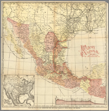
Mexico National R.R.
Full Title
Mexico National R.R. and Connections.
Publisher
Mexico National R.R.
Author
Mexico National R.R.
Full Title
Map of the Mexico National R.R. Loredo Route and Connections. The Scenic Short Line to the City of Mexico.
Publisher
Mexico National R.R.
Author
[Ludkins, Fred, Terry, T. Philip, Martinez, Judith, Montenegro, Roberto (1885-1968)]
Full Title
A Map of Mexico. (Views) Azatlan, Sinaloa, and Guaymas, Sonora.
Publisher
Southern Pacific Company
Author
Watson, Walter
Full Title
Railway and highway map of the famous Berkshire Hills region, showing also villages and points of interest : from official records and other information, by Walter Watson, c.e. for the Berkshire Life Insurance Co. of Pittsfield, Mass., 1883. (Corrected 1896.) Copyright, 1883 by Walter Watson C.E. Sun Printing Co. Pittsfield, Mass.
Publisher
Berkshire Life Insurance Co.
|