Who What Where WhenREMOVEWHO
|
REFINE
Browse All : Railroad of Mexico and West Indies
1-8 of 8
Author
Colton, G.W & C.B.
Full Title
(Covers to) Colton's Railroad And Military Map Of The United States, Mexico, The West Indies &c. By J.H. Colton, New York, 1862. Entered ... 1862, by J.H. Colton ... New York.
Publisher
G.W. & C.B. Colton.
Author
Colton, G.W & C.B.
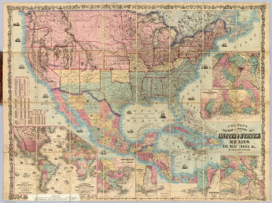
Full Title
Colton's Railroad And Military Map Of The United States, Mexico, The West Indies &c. Published By G.W. & C.B. Colton, 172 William St. New York. 1865. Printed by Cooper 117 Fulton St. N.Y. (inset) Colton's Map Of The Americas, Africa And A Portion Of Europe, Showing The Atlantic And Part Of The Pacific Oceans. (8 additional inset maps).
Publisher
G.W. & C.B. Colton.
Author
Goldthwait, J.H.
Full Title
(Covers to) Goldthwait's Map Of The United States, British Provinces, Mexico, Central America, W. India Is. &c. Exhibiting The Railroads ... by J.H. Goldthwait. Published by D. Chester, 119 & 121 Nassau St. New York. Entered ... 1861 by J.H. Goldthwait ... New York. (inset) Great Rail Road Routes from the Middle Atlantic Ports To The Mississippi River by J.H. Goldthwait. (inset) Of The Railroads Of New England And Eastern N . York by J.H. Goldthwait.
Publisher
D. Chester
Author
Goldthwait, J.H.
Full Title
Goldthwait's Map Of The United States, British Provinces, Mexico, Central America, W. India Is. &c. Exhibiting The Railroads ... by J.H. Goldthwait. Published by D. Chester, 119 & 121 Nassau St. New York. Entered ... 1861 by J.H. Goldthwait ... New York. (inset) Great Rail Road Routes from the Middle Atlantic Ports To The Mississippi River by J.H. Goldthwait. (inset) Of The Railroads Of New England And Eastern N . York by J.H. Goldthwait.
Publisher
D. Chester
Full Title
Map of Mexico, Central America, and the West Indies. (with) Map of the Bermuda Islands. (with) Map of the island of Jamaica. (with) Map of the proposed ship rail road route across the isthmus of Tehuantepec. (with) Map of the Panama Railroad and proposed canal. (with) Map of the proposed Nicaragua Canal route. Copyright 1887 by Wm. M. Bradley & Bro. (1890)
Publisher
John Y. Huber & Co.
Author
[Mitchell, Samuel Augustus, Williams, W. (Wellington)]
Full Title
Map of Mexico, Central America, and the West Indies. (with) Map of the island of Cuba. (with) Map of the island of Jamaica. (with) Map of the Bermuda Islands. (with) Map of the Panama Railroad. Constructed & engraved by W. Williams, Philadelphia. Entered ... 1870 by S. Augustus Mitchell, Jr. ... Pennsylvania.
Publisher
[R.A. Campbell, S.A. Mitchell, Jr.]
Author
Mitchell, Samuel Augustus Jr.
Full Title
Map of Mexico, Central America, and the West Indies. (with) Map of the Bermuda Islands. (with) Map of the island of Jamaica. (with) Map of the proposed ship rail road route across the isthmus of Tehuantepec. (with) Map of the Panama Railroad and proposed canal. (with) Map of the proposed Nicaragua Canal route. Copyright by S. Augustus Mitchell 1884.
Publisher
Wm. M. Bradley & Bro.
Full Title
Map of Mexico, Central America, and the West Indies. (with) Map of the Bermuda Islands. (with) Map of the island of Jamaica. (with) Map of the proposed ship rail road route across the isthmus of Tehuantepec. (with) Map of the Panama Railroad and proposed canal. (with) Map of the proposed Nicaragua Canal route. Copyright 1886 by Wm. M. Bradley & Bro.
Publisher
Wm. M. Bradley & Bro.
1-8 of 8
|