Who What Where WhenREMOVEWHO
WHEN
|
Author
Southern Pacific Company
Full Title
(Covers to) A List of Government And Railroad Lands in California, Open to Preemption or Homestead or to Purchase. Southern Pacific Company, New Orleans to San Francisco Via the Sunset Route. With Complements of the New York General Agency. 339 Broadway. L.H. Nutting, Eastern passenger Agent. E. Hawley, Genl. Eastern Agent. (with map) The Great Sunset Route. Shortest Line between the Atlantic and the Pacific Oceans... Boston Agency: 192 Washington Street 192. General Eastern Agency: New York city, 339 Broadway. (with) Map of summer & winter resorts and other places upon and near the Central & Southern Pacific railroads in California. D. Van Vleck S.F. Eng. F.T. Newbery Del.
Publisher
Southern Pacific Company
Author
Southern Pacific Company
Full Title
The Great Sunset Route. Shortest Line between the Atlantic and the Pacific Oceans... Boston Agency: 192 Washington Street 192. General Eastern Agency: New York city, 339 Broadway. (with) Map of summer & winter resorts and other places upon and near the Central & Southern Pacific railroads in California. D. Van Vleck S.F. Eng. F.T. Newbery Del. (with catalog) A List of Government And Railroad Lands in California, Open to Preemption or Homestead or to Purchase. Southern Pacific Company, New Orleans to San Francisco Via the Sunset Route. With Complements of the New York General Agency. 339 Broadway. L.H. Nutting, Eastern passenger Agent. E. Hawley, Genl. Eastern Agent.
Publisher
Southern Pacific Company
Author
Southern Pacific Company
Full Title
(Text page to) A List of Government And Railroad Lands in California, Open to Preemption or Homestead or to Purchase. Southern Pacific Company, New Orleans to San Francisco Via the Sunset Route. With Complements of the New York General Agency. 339 Broadway. L.H. Nutting, Eastern passenger Agent. E. Hawley, Genl. Eastern Agent. (with map) The Great Sunset Route. Shortest Line between the Atlantic and the Pacific Oceans... Boston Agency: 192 Washington Street 192. General Eastern Agency: New York city, 339 Broadway. (with) Map of summer & winter resorts and other places upon and near the Central & Southern Pacific railroads in California. D. Van Vleck S.F. Eng. F.T. Newbery Del.
Publisher
Southern Pacific Company
Author
Southern Pacific Company
Full Title
Map of summer & winter resorts and other places upon and near the Central & Southern Pacific railroads in California. D. Van Vleck S.F. Eng. F.T. Newbery Del. (with map)The Great Sunset Route. Shortest Line between the Atlantic and the Pacific Oceans... Boston Agency: 192 Washington Street 192. General Eastern Agency: New York city, 339 Broadway. (with catalog) A List of Government And Railroad Lands in California, Open to Preemption or Homestead or to Purchase. Southern Pacific Company, New Orleans to San Francisco Via the Sunset Route. With Complements of the New York General Agency. 339 Broadway. L.H. Nutting, Eastern passenger Agent. E. Hawley, Genl. Eastern Agent.
Publisher
Southern Pacific Company
Author
Stieler, Adolf
Full Title
Deutschland Und Benachbarte Lander. Zur Ubersicht Der Eisenbahnen Und Dampfschiffahrten. Bearbeitet von C. Vogel. Abgeschlossen im August 1871. Gestochen von H. Eberhardt. Gotha: Justus Perthes. 1872.
Publisher
Justus Perthes
Author
Cram, George Franklin
Full Title
Railroad and County Map of New Jersey.
Publisher
A.C. Shewey and Co.
Author
Cram, George Franklin
Full Title
New Rail Road and County Map of Deleware (Delaware), Maryland, Virginia & West Virginia.
Publisher
A.C. Shewey and Co.
Author
Cram, George Franklin
Full Title
New Rail Road and Count Map of North Carolina.
Publisher
A.C. Shewey and Co.
Author
Cram, George Franklin
Full Title
New Rail Road and County Map of Alabama, Georgia, Sth. Carolina & Northern Florida.
Publisher
A.C. Shewey and Co.
Author
Cram, George Franklin
Full Title
New Rail Road and County Map of Kentucky & Tennessee.
Publisher
A.C. Shewey and Co.
Author
Cram, George Franklin
Full Title
New Rail Road and County Map of Missouri.
Publisher
A.C. Shewey and Co.
Author
Cram, George Franklin
Full Title
New Rail Road and County Map of Michigan & Wisconsin.
Publisher
A.C. Shewey and Co.
Author
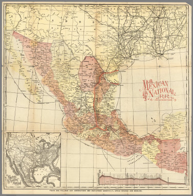
Mexico National R.R.
Full Title
Mexico National R.R. and Connections.
Publisher
Mexico National R.R.
Author
Mexico National R.R.
Full Title
Map of the Mexico National R.R. Loredo Route and Connections. The Scenic Short Line to the City of Mexico.
Publisher
Mexico National R.R.
Author
[Lane, John J., New England Street Railway Club]
Full Title
Trolley Wayfinder : birds eye view of trolley routes in New England. New England street Railway Club. 12 Pearl St. Copyright 1904, 1905, 1906, 1907, by the New England Street Railway Club. Geo. H. Walker & Co. Boston. (with 7 insets). (cover title) Trolley Wayfinder : birds eye view of trolley routes in New England. Published by New England street Railway Club. ... John J. Lane Editor of "Trolley Wayfinder" and Trolley Wayfinder birds eye view of trolley routes. Price 10 Cents.
Publisher
[New England Street Railway Club, Geo. H. Walker & Co.]
Author
[Ludkins, Fred, Terry, T. Philip, Martinez, Judith, Montenegro, Roberto (1885-1968)]
Full Title
A Map of Mexico. (Views) Azatlan, Sinaloa, and Guaymas, Sonora.
Publisher
Southern Pacific Company
Author
Watson, Walter
Full Title
Railway and highway map of the famous Berkshire Hills region, showing also villages and points of interest : from official records and other information, by Walter Watson, c.e. for the Berkshire Life Insurance Co. of Pittsfield, Mass., 1883. (Corrected 1896.) Copyright, 1883 by Walter Watson C.E. Sun Printing Co. Pittsfield, Mass.
Publisher
Berkshire Life Insurance Co.
Author
General Drafting Company
Full Title
Mapa turistico de America del Sur. (with) Mapa fisico de America del Sur. (and with 11 insets). (on verso) Mapa panoramico de America del Sur. (Scale: 1:8,772,000). (with 3 insets). Copyright, General Drafting Co., Inc. Convent Station, N.J., U.S. Esso Touring Service, Foreign Department, 15 West 51 Street, New York 19, N.Y., E.U.A. Lithographed in U.S.A. (cover title) Guia turistica de America del Sur. Este mapa se obtiene Gratuitamente en los servicentros Esso. Celebrate April 14th. Pan American Day. Impreso en E.U.A.
Publisher
General Drafting Co.
Author
Eddy, Gerald A.
Full Title
Panoramic perspective of the area adjacent to Boulder Dam as it will appear when lake is filled : Served exclusively by tge Union Pacific System. "The boulder Dam Route". copyright, 1935, for Union Pacific System. Gerald A Eddy, L.A. Calif. Printed in U.S.A. By Poole Bros., Inc. Chicago. "50M 10-35". (Cover title on verso) Boulder Dam : Union Pacific, the Boulder Dam Route.
Publisher
Poole Bros., Inc.
Author
[Gray, Ormando Willis, Walling, H. F.]
Full Title
Map of Massachusetts comprising counties, towns, villages, railroads, stations, etc. H.F. Walling & O.W. Gray, Boston, 1871.
Publisher
Stedman, Brown & Lyon
Author
Bradford, Thomas G.
Full Title
United States, exhibiting the railroads & canals. (to accompany) A Comprehensive Atlas, Geographical, Historical & Commercial. By T.G. Bradford. William D. Ticknor, Boston. Wiley & Long, New-York. Entered ... 1835, by Thos. G. Bradford ... Massachusetts.
Publisher
[William D. Ticknor, Wiley & Long]
Author
Bradford, Thomas G.
Full Title
(Text Page to) Canals and railroads. (to accompany) A Comprehensive Atlas, Geographical, Historical & Commercial. By T.G. Bradford. William D. Ticknor, Boston. Wiley & Long, New-York. Entered ... 1835, by Thos. G. Bradford ... Massachusetts.
Publisher
[William D. Ticknor, Wiley & Long]
Author
Gray, Frank Arnold
Full Title
Railway map of the state of Pennsylvania, 1872. Drawn by F.A. Gray. (Published by Stedman, Brown & Lyon, Philadelphia)
Publisher
Stedman, Brown & Lyon
Author
Freyhold, Edward; Warren, Gouverneur Kemble, 1830-1882
Full Title
(NW Sheet to) Territory Of The United States From The Mississippi River To The Pacific Ocean; Originally prepared to accompany the Reports of the Explorations For A Pacific Railroad Route ... Compiled from authorized explorations and other reliable data by Lieut. G.K. Warren, Top'l. Eng'rs. In the Office of Pacific R.R. Surveys, War Dept. under the direction of Bvt. Maj. W.H. Emory, Top'l. Eng'rs. in 1854. Capt. A.A. Humphreys, Top'l. Eng'rs. in 1854-58. Recompiled and redrawn under the direction of the Chief of Corps of Engineers By Edward Freyhold 1865-66-67-68. Head Quarters Corp Of Engineers, War Department. Engraved & printed by Julius Bien, N.Y. (inset) Territory Of Alaska Ceded By Russia To The United States 1868.
Publisher
Julius Bien
Author
Freyhold, Edward; Warren, Gouverneur Kemble, 1830-1882
Full Title
(Composite of) Territory Of The United States From The Mississippi River To The Pacific Ocean; Originally prepared to accompany the Reports of the Explorations For A Pacific Railroad Route ... Compiled from authorized explorations and other reliable data by Lieut. G.K. Warren, Top'l. Eng'rs. In the Office of Pacific R.R. Surveys, War Dept. under the direction of Bvt. Maj. W.H. Emory, Top'l. Eng'rs. in 1854. Capt. A.A. Humphreys, Top'l. Eng'rs. in 1854-58. Recompiled and redrawn under the direction of the Chief of Corps of Engineers By Edward Freyhold 1865-66-67-68. Head Quarters Corp Of Engineers, War Department. Engraved & printed by Julius Bien, N.Y. (inset) Territory Of Alaska Ceded By Russia To The United States 1868.
Publisher
Julius Bien
Author
Freyhold, Edward; Warren, Gouverneur Kemble, 1830-1882
Full Title
(SW Sheet to) Territory Of The United States From The Mississippi River To The Pacific Ocean; Originally prepared to accompany the Reports of the Explorations For A Pacific Railroad Route ... Compiled from authorized explorations and other reliable data by Lieut. G.K. Warren, Top'l. Eng'rs. In the Office of Pacific R.R. Surveys, War Dept. under the direction of Bvt. Maj. W.H. Emory, Top'l. Eng'rs. in 1854. Capt. A.A. Humphreys, Top'l. Eng'rs. in 1854-58. Recompiled and redrawn under the direction of the Chief of Corps of Engineers By Edward Freyhold 1865-66-67-68. Head Quarters Corp Of Engineers, War Department. Engraved & printed by Julius Bien, N.Y. (inset) Territory Of Alaska Ceded By Russia To The United States 1868.
Publisher
Julius Bien
Author
Freyhold, Edward; Warren, Gouverneur Kemble, 1830-1882
Full Title
(SE Sheet to) Territory Of The United States From The Mississippi River To The Pacific Ocean; Originally prepared to accompany the Reports of the Explorations For A Pacific Railroad Route ... Compiled from authorized explorations and other reliable data by Lieut. G.K. Warren, Top'l. Eng'rs. In the Office of Pacific R.R. Surveys, War Dept. under the direction of Bvt. Maj. W.H. Emory, Top'l. Eng'rs. in 1854. Capt. A.A. Humphreys, Top'l. Eng'rs. in 1854-58. Recompiled and redrawn under the direction of the Chief of Corps of Engineers By Edward Freyhold 1865-66-67-68. Head Quarters Corp Of Engineers, War Department. Engraved & printed by Julius Bien, N.Y. (inset) Territory Of Alaska Ceded By Russia To The United States 1868.
Publisher
Julius Bien
Author
Freyhold, Edward; Warren, Gouverneur Kemble, 1830-1882
Full Title
(NE Sheet to) Territory Of The United States From The Mississippi River To The Pacific Ocean; Originally prepared to accompany the Reports of the Explorations For A Pacific Railroad Route ... Compiled from authorized explorations and other reliable data by Lieut. G.K. Warren, Top'l. Eng'rs. In the Office of Pacific R.R. Surveys, War Dept. under the direction of Bvt. Maj. W.H. Emory, Top'l. Eng'rs. in 1854. Capt. A.A. Humphreys, Top'l. Eng'rs. in 1854-58. Recompiled and redrawn under the direction of the Chief of Corps of Engineers By Edward Freyhold 1865-66-67-68. Head Quarters Corp Of Engineers, War Department. Engraved & printed by Julius Bien, N.Y. (inset) Territory Of Alaska Ceded By Russia To The United States 1868.
Publisher
Julius Bien
Author
Lloyd, James T.
Full Title
Lloyd's American railroad map of the United States, showing the three proposed roads and the overland mail route to the Pacific 1859. Drawn and engraved by Rae Smith, 71 Nassau St. N.Y. From materials furnished to the 36th Congress, March 1859 by G.K. Warren, Lt. U.S. Top. Eng. for the passage of the Pacific Railroad Bill. Entered ... 1859, by J.T. Lloyd ... Pensylvania.
Publisher
J.T. Lloyd
Author
[Gray, Frank A., Gray, O.W.]
Full Title
Gray's Atlas New Rail Road and County Map of the States of Oregon, California, and Nevada Compiled and Drawn by Frank A. Gray. Published by O.W. Gray, Phladelphia. (inset) Enlarged Plan of the Vicinity of San Francisco and Sacramento.
Publisher
Stedman, Brown & Lyon
Author
Cram, George Franklin
Full Title
Cram's Rail Road & Township Map of Illinois.
Publisher
George F. Cram
Author
Cram, George Franklin
Full Title
Cram's Rail Road & Township Map of Iowa.
Publisher
George F. Cram
Author
Cram, George Franklin
Full Title
Cram's Rail Road & Township Map of Missouri.
Publisher
George F. Cram
Author
Cram, George Franklin
Full Title
Cram's Rail Road & Township Map of Kansas.
Publisher
George F. Cram
Author
Cram, George Franklin
Full Title
Cram's Rail Road & Township Map of Nebraska.
Publisher
George F. Cram
Author
Cram, George Franklin
Full Title
Cram's Rail Road & Township Map of Minnesota.
Publisher
George F. Cram
Author
Cram, George Franklin
Full Title
Cram's Rail Road & Township Map of Wisconsin.
Publisher
George F. Cram
Author
Cram, George Franklin
Full Title
Cram's Rail Road & Township Map of Michigan.
Publisher
George F. Cram
Author
Cram, George Franklin
Full Title
Cram's Rail Road & Township Map of Indiana.
Publisher
George F. Cram
Author
Cram, George Franklin
Full Title
Cram's Rail Road & Township Map of Ohio.
Publisher
George F. Cram
Author
Cram, George Franklin
Full Title
Cram's Rail Road & Township Map of Arkansas.
Publisher
George F. Cram
Author
Cram, George Franklin
Full Title
Cram's Rail Road & Township Map of Kentucky & Tennessee.
Publisher
George F. Cram
Author
Cram, George Franklin
Full Title
Cram's Rail Road & County Map of Texas.
Publisher
George F. Cram
Author
Cram, George Franklin
Full Title
Cram's Rail Road & Township Map of Indian Ty.
Publisher
George F. Cram
Author
Cram, George Franklin
Full Title
Cram's Rail Road & Township Map of Miss. & Alabama.
Publisher
George F. Cram
Author
Cram, George Franklin
Full Title
Cram's Rail Road & Township Map of Georgia.
Publisher
George F. Cram
|