Browse All

1787 A new chart of the coast of Guyana from … Regional Atlas A new chart of the coast of Guyana from … |

1788 Cover: West-India atlas. Regional Atlas (Covers to) The West-India atlas: or, a … |

1788 Engraved Title Page: West-India atlas: o … Regional Atlas (Engraved title page to) The West-India … |

1788 Title page: West-India atlas: or, a comp … Regional Atlas (Title page to) The West-India atlas: or … |

1788 (Dedication page to) The West-India atla … Regional Atlas (Dedication page to) The West-India atla … |

1788 Index: West-India atlas. Regional Atlas (Index page to) The West-India atlas: or … |

1877 Upper Ohio River and Valley part IV, 47 … Regional Atlas Upper Ohio River and Valley part IV, 47 … |

1877 Soho Saw & Planing Mills & Barge Yards . … Regional Atlas Soho Saw & Planing Mills & Barge Yards, … |

1877 Upper Ohio River and Valley part XVI, 27 … Regional Atlas Upper Ohio River and Valley part XVI, 27 … |

1877 Upper Ohio River and Valley part XVII, 2 … Regional Atlas Upper Ohio River and Valley part XVII, 2 … |

1877 Gallipolis, Gallia Co., Ohio. Regional Atlas Gallipolis, Gallia Co., Ohio. (... compi … |

1877 Property of the Hartford City Coal & Sal … Regional Atlas Property of the Hartford City Coal & Sal … |

1877 Upper Ohio River and Valley part XXV, 43 … Regional Atlas Upper Ohio River and Valley part XXV, 43 … |

1877 Residence of Jacob Markley Esq., Anderso … Regional Atlas Residence of Jacob Markley Esq., Anderso … |

1946 Covers: Preliminary Report on Harbors, H … [Regional Atlas, Aerial Photographs] (Covers to) Preliminary Report on Harbor … |

1946 Title Page: Preliminary Report on Harbor … [Regional Atlas, Aerial Photographs] (Title Page) Preliminary Report on Harbo … |

1946 Text: Photographic Credits. [Aerial Photographs, Regional Atlas] (Text Page) The excellent photographs we … |

1946 Text: Introductory Page. [Regional Atlas, Aerial Photographs] (Text Page) Introductory Page. |

1946 Southeast Farralon Island. [Aerial Photographs, Regional Atlas] SE Farralon. |

1946 Golden Gate Bridge, San Francisco, Calif … [Aerial Photographs, Regional Atlas] Golden Gate SF |

1946 Bolinas Bay, California. [Regional Atlas, Aerial Photographs] Bolinas Bay. |

1946 Bolinas Bay. Duxbury Reef. [Regional Atlas, Aerial Photographs] Bolinas Bay. Duxbury Reef. |

1946 Drakes Bay and Pt. Reyes. [Regional Atlas, Aerial Photographs] Drakes Bay and Pt. Reyes. |

1946 Bodega Bay. [Aerial Photographs, Regional Atlas] Bodega Bay. |

1946 Bodega Bay. [Aerial Photographs, Regional Atlas] Bodega Bay. |

1946 Mendocino Bay. [Aerial Photographs, Regional Atlas] Mendocino Bay. |

1946 Noya Harbor. Fort Bragg. [Aerial Photographs, Regional Atlas] Noya Harbor. Fort Bragg. |

1946 Noyo River. [Aerial Photographs, Regional Atlas] Noyo River. |

1946 Cape Mendocino. Blunt's Reef. [Aerial Photographs, Regional Atlas] Cape Mendocino. Blunt's Reef. |

1946 Eel River Outlet. [Aerial Photographs, Regional Atlas] Eel River Outlet. |

1946 Humboldt Bay Entrance. [Aerial Photographs, Regional Atlas] Humboldt Bay Entrance. |

1946 Humboldt Bay Entrance. Eureka. [Aerial Photographs, Regional Atlas] Humboldt Bay Entrance. Eureka. |

1946 Humboldt Bay Entrance. [Aerial Photographs, Regional Atlas] Humboldt Bay Entrance. |

1946 Trinidad Head. [Aerial Photographs, Regional Atlas] Trinidad Head. |

1946 Crescent City. [Aerial Photographs, Regional Atlas] Crescent City. |

1946 Crescent City. [Aerial Photographs, Regional Atlas] Crescent City. |

1946 Rogue River Outlet. [Aerial Photographs, Regional Atlas] Rogue River outlet. |

1946 Rogue River Outlet. [Aerial Photographs, Regional Atlas] Rogue River. |

1946 Port Orford. [Aerial Photographs, Regional Atlas] Port Orford. |
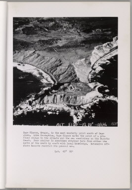
1946 Cape Blanco. [Aerial Photographs, Regional Atlas] Cape Blanco. |

1946 Cape Blanco. [Aerial Photographs, Regional Atlas] Cape Blanco. |

1946 Bandon. Coquille River. [Aerial Photographs, Regional Atlas] Bandon. Coquille River. |

1946 Bandon. Coquille River. [Aerial Photographs, Regional Atlas] Bandon. Coquille River. |

1946 Cape Arago. [Aerial Photographs, Regional Atlas] Cape Arago. |

1946 Coos Bay Entrance. [Aerial Photographs, Regional Atlas] Coos Bay Entrance. |

1946 Umpqua River entrance. [Aerial Photographs, Regional Atlas] Umpqua River entrance. |

1946 Umpqua River. Winchester Bay. [Aerial Photographs, Regional Atlas] Umpqua River. Winchester Bay. |

1946 Siuslaw River. Munsel Lake. [Aerial Photographs, Regional Atlas] Siuslaw River. Munsel Lake. |

1946 Alsea River Entrance. [Regional Atlas, Aerial Photographs] Alsea River Entrance. |

1946 Yaquina Bay. [Aerial Photographs, Regional Atlas] Yaquina Bay. |