Browse All

1796 Passage of a Branch of the river Juniata … National Atlas Passage of a Branch of the river Juniata … |

1796 Map of the Course of The Mississippi fro … National Atlas Map of the Course of The Mississippi fro … |

1885 Carta Hydrografica. National Atlas Carta Hydrografica. VII. A. Garcia Cubas … |

1865 Mountains and Rivers. World Atlas Mountains & Rivers. |

1865 Text: Principal Rivers and Lakes of the … World Atlas (Text Page) Principal Rivers and Lakes i … |

1869 Text: Principal Rivers and Lakes in the … World Atlas (Text Page) Principal Rivers and Lakes i … |

1869 Mountains and Rivers in the World. World Atlas Mountains & Rivers. Published by G. W. & … |

1873 Carte, cours du Haut Uruguay, 1. flle. C … National Atlas Carte du cours du Haut Uruguay depuis la … |

1873 Carte, cours du Haut Uruguay, 2. flle. U … National Atlas Carte du cours du Haut Uruguay depuis la … |

1873 Rio Paraguay; chutes, Rio Parana et Y-Gu … National Atlas Cours inferieur et bouches du Rio Paragu … |

1888 Mapa orohidrografico de la Republica Arg … National Atlas Mapa orohidrografico de la Republica Arg … |

1886 Ocean Currents and the Great River Basin … World Atlas Johnson's Ocean Currents and the Great R … |

1831 Table of the Comparative Lengths of the … [Classical Atlas, World Atlas] Table of the Comparative Lengths of the … |

1823 Comparative Lengths of the Principal Riv … World Atlas Comparative Lengths of the Principal Riv … |

1856 River Systems of America. Physical Atlas The River Systems of America showing the … |

1856 River Systems of America. (continued) Physical Atlas The River Systems of America showing the … |

1856 Distribution of Heat over the Globe. Physical Atlas Distribution of Heat over the Globe. Iso … |

1856 Distribution of Heat over the Globe. (co … Physical Atlas Distribution of Heat over the Globe. Iso … |

1856 Geographical Distribution of Winds and S … Physical Atlas Geographical Distribution of Winds and S … |

1856 Geographical Distribution of Winds and S … Physical Atlas Geographical Distribution of Winds and S … |

1856 Geographical Distribution of Winds and S … Physical Atlas Geographical Distribution of Winds and S … |

1815 Map of Detroit River and Adjacent Countr … National Atlas Map of Detroit River and Adjacent Countr … |

1810 Map of the Mississippi River from its So … Exploration Book Map of the Mississippi River from its So … |
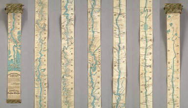
1866 Ribbon Map Of The Father Of Waters. Separate Map Coloney & Fairchild's Patent Ribbon Maps … |

1858 World Land and Co-Tidal Lands. World Oce … World Atlas The World Illustrating the Principal Fea … |

1865 Lecho, Rio Amazonas; Corte vertical, cam … National Atlas Lecho del Rio Amazonas segun los sondeos … |