Browse All

1841 Asia-Europa; in Beziehung auf das Fliess … World Atlas Asia-Europa; in Beziehung auf das Fliess … |

1842 Stromgebiete Der Neuen Welt. World Atlas Stromgebiete Der Neuen Welt. 2te Abtheil … |

1839 Ubersicht der bekannteren Gabeltheilunge … World Atlas Ubersicht der bekannteren Gabeltheilunge … |

1843 Vermischtes zur Hydrographie: Schwankung … World Atlas Vermischtes zur Hydrographie: Schwankung … |

1837 Hydro-Historische Darstellung vom Zustan … World Atlas Hydro-Historische Darstellung vom Zustan … |

1837 Hydro-Historische Ubersicht vom Zustande … World Atlas Hydro-Historische Ubersicht vom Zustande … |

1838 Hydro-Historische Ubersicht vom Zustande … World Atlas Hydro-Historische Ubersicht vom Zustande … |

1841 Vergleichende Ubersicht Vom Zustande Des … World Atlas Vergleichende Ubersicht Vom Zustande Des … |

1838 Die Deutschen Strome Rhein, Elbe, Oder. World Atlas Die Deutschen Strome Rhein, Elbe, Oder; … |

1842 Hydrographisches Tableau Der Weser, Weic … World Atlas Hydrographisches Tableau Der Weser, Weic … |

1881 Drainage Map of Colorado. State Atlas Drainage Map of Colorado. Topography by … |

1776 An Exact Chart of the River St. Laurence … National Atlas An Exact Chart of the River St. Laurence … |

1776 Course Of The River Mississipi, from the … National Atlas Course Of The River Mississipi, from the … |

1794 Map of the Tennessee Government. Geography Book A Map of the Tennessee Government. 1794. … |

1843 Title Page: Report intended to illustrat … Exploration Book (Title Page to) Report Intended To Illus … |

1843 Hydrographical Basin of the Upper Missis … Exploration Book Hydrographical Basin of the Upper Missis … |

1886 Text: Principal Rivers and Lakes in the … World Atlas (Text Page) Principal Rivers and Lakes i … |

1886 Mountains and Rivers in the World. World Atlas Mountains & Rivers. Published by G. W. & … |

1874 Text Page: Principal Rivers and lakes in … World Atlas (Text Page) Principal Rivers and Lakes i … |

1874 Mountains and Rivers of the World. World Atlas Mountains & Rivers. |

1834 Map of the principal rivers: courses, co … World Atlas A map of the principal rivers shewing th … |

1866 Mountains and Rivers. World Atlas Mountains & Rivers. Published by G.W. & … |

1866 Text: Principal Rivers and lakes of the … World Atlas (Text Page) Principal Rivers and Lakes i … |

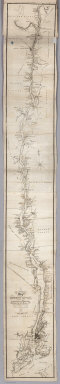
1858 Chart Of The Lower Mississippi River. Pocket Map Norman's Chart Of The Lower Mississippi … |

1964 Sea, Lakes, And Rivers State Atlas 10. Sea, Lakes, And Rivers. Sources: Flo … |

1835 A Reconnoissance Of The Minnay Sotor Wat … Separate Map A Reconnoissance Of The Minnay Sotor Wat … |

1824 Table of the Comparative Lengths of the … World Atlas Table of the Comparative Lengths of the … |

1860 Strome der Erde. World Atlas Vergleichende Ubersicht der grossten Str … |

1856 Rivers and Lakes (key) World Atlas Principal rivers and lakes in the World. … |

1866 Ribbon Map Of The Father Of Waters. Separate Map Coloney & Fairchild's Patent Ribbon Maps … |

1848 Flusskarte, Asien. World Atlas Flusskarte von Asien. Nach den besten Qu … |

1847 Stromgebiet, Nordamerica. World Atlas Stromgebiet von Nordamerica. Nach den be … |

1877 Text Page: River Systems. (New Hampshire … State Atlas (Text Page) The River Systems. |

1877 Text Page: River Systems (concluded). (N … State Atlas (Text Page) The River Systems (concluded … |

1895 Parts Arkansas, Louisiana. Military Atlas Parts of Arkansas and Louisiana. Respect … |

1901 Hydrographical map, British Isles. World Atlas A hydrographical map of the British Isle … |

1825 Rivieres. National Atlas Carte des principales rivieres du globe. … |

1837 Hydrographische Karte von Europa. Physical Atlas Hydrographische Karte von Europa, oder d … |

1883 5. River basins, Forestry. Statistical Atlas River basins. Based on the reports of th … |

1832 Length, rivers of Scotland. National Atlas A comparative view of the lengths of the … |

1864 Table of the Comparative Lengths of the … World Atlas Table of the Comparative Lengths of the … |

1830 Covers: The Hudson River, The Western Ca … Guide Book (Covers to) The Tourist, Or Pocket Manua … |
1830 Map Of The Hudson River, The Western Can … Guide Book An Improved Map of the Hudson River, wit … |

1863 Map of the Lower Mississippi River From … Separate Map Lloyd's Map of the Lower Mississippi Riv … |

1864 New Map of the United States The Canadas … Separate Map Lloyd's New Map of the United States, Th … |

1966 Road Network. National Atlas Road Network. |

1868 Title Page: Report of the Secretary of W … Exploration Book (Title Page to) Report of the Secretary … |

1868 Title Page: (Continues) Report of the Se … Exploration Book (Title Page to) Report of the Secretary … |
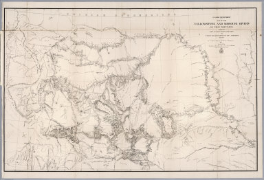
1868 Map of the Yellowstone and Missouri Rive … Exploration Book U.S. War Department : Map of the Yellows … |

1852 View: World Atlas (View) Tableau Indiquant la Longueur des … |