Who What Where WhenREMOVEWHERE
WHOShow More |
REFINE
Browse All : Roads and Streets and World Atlas
1-18 of 18
Author
Stieler, Adolf
Full Title
No. XXVI. Stieler's Hand-Atlas (No. 20.) Deutschland und anliegende Lander, zur Ubersicht der Eisenbahnen und Hauptstrassen.
Publisher
Justus Perthes
Author
Stieler, Adolf
Full Title
No. XXVI. Stieler's Hand-Atlas (No. 20.) Deutschland und anliegende Lander, zur Ubersicht der Eisenbahnen und Hauptstrassen.
Publisher
Justus Perthes
Author
Cummins Map Co.
Full Title
Road Map of the Maritime Provinces. (inset) Prince Edward Island.
Publisher
Cummins Map Co.
Author
Gray, Ormando Willis
Full Title
Map of Richmond, Henrico County, Virginia. (inset continuation of main map).
Publisher
O.W. Gray & Son
Author
Gray, Ormando Willis
Full Title
Edinburg, Shenandoah County, Virginia.
Publisher
O.W. Gray & Son
Author
Gray, Ormando Willis
Full Title
Woodstock, Shenandoah County, Virginia.
Publisher
O.W. Gray & Son
Author
Gray, Ormando Willis
Full Title
Mt. Jackson, Shenandoah County, Virginia. New Market, Shenandoah County, Virginia.
Publisher
O.W. Gray & Son
Author
Gray, Ormando Willis
Full Title
Gray's New Map of Lexington, Rockingham County, Virginia. Drawn from Special Surveys, 1877. Drawn, Engraved, and Published by O.W. Gray & Son, Geographers, Manufacturers of Maps and Atlases, 10 North Fifth Street, Philadelphia. Jacob Chace, Topographical Engineer, Manager of Local Surveys.
Publisher
O.W. Gray & Son
Author
Gray, Ormando Willis
Full Title
Luray, Page County, Virginia.
Publisher
O.W. Gray & Son
Author
Gray, Ormando Willis
Full Title
Newtown, (Newtown-Stephenburgh P.O.), Frederick County, Virginia.
Publisher
O.W. Gray & Son
Author
Gray, Ormando Willis
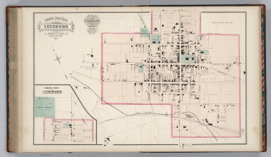
Full Title
Gray's New Map of Leesburg, Loudoun Co., Virginia. Drawn from Special Surveys, 1878. Drawn, Engraved, and Published by O.W. Gray & Son, Geographers, Manufacturers of Maps and Atlases, 10 North Fifth Street, Philadelphia. Jacob Chace, Topographical Engineer, Manager of Local Surveys. George Chace, Assistant Engineer. (inset a continuation of main map).
Publisher
O.W. Gray & Son
Author
Gray, Ormando Willis
Full Title
Strasburg, Shenandoah County, Virginia.
Publisher
O.W. Gray & Son
Author
Gray, Ormando Willis
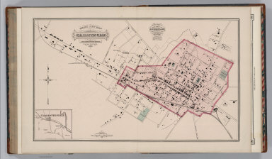
Full Title
Gray's New Map of Charlottesville, Albemarle County, Virginia. Drawn from Special Surveys, 1877. Drawn, Engraved, and Published by O.W. Gray & Son, Geographers, Manufacturers of Maps and Atlases, 10 North Fifth Street, Philadelphia. Jacob Chace, Topographical Engineer, Manager of Local Surveys. (inset) (Vicinity of) Charlottesville.
Publisher
O.W. Gray & Son
Author
Gray, Ormando Willis
Full Title
Map of Orange Court House, Orange County, Virginia. Philadelphia: O.W. Gray & Son.
Publisher
O.W. Gray & Son
Author
Gray, Ormando Willis
Full Title
Gray's New Map of Culpepper, Culpepper County, Virginia. Drawn from Special Surveys, 1878. Drawn, Engraved, and Published by O.W. Gray & Son, Geographers, Manufacturers of Maps and Atlases, 10 North Fifth Street, Philadelphia. Jacob Chace, Topographical Engineer, Manager of Local Surveys. George Chace, Assistant Engineer.
Publisher
O.W. Gray & Son
Author
Gray, Ormando Willis
Full Title
Gray's New Map of Gordonsville, Orange County, Virginia. Drawn from Special Surveys, 1878. Philadelphia: O.W. Gray & Son. Gray's New Map of Harrisonburg (Outline), Rockingham County, Virginia. Drawn from Special Surveys, 1877. Philadelphia: O.W. Gray & Son.
Publisher
O.W. Gray & Son
Author
Gray, Ormando Willis
Full Title
Gray's New Map of Harrisonburg, Rockingham Co., Virginia. Drawn from Special Surveys, 1877. Drawn, Engraved, and Published by O.W. Gray & Son, Geographers, Manufacturers of Maps and Atlases, 10 North Fifth Street, Philadelphia. Jacob Chace, Topographical Engineer, Manager of Local Surveys.
Publisher
O.W. Gray & Son
1-18 of 18
|