|
REFINE
Browse All : Images of South Carolina and Libya from 1736
1-6 of 6
Author
[Humboldt, Alexander von, 1769-1859, Vandermaelen, Philippe, 1795-1869]
Full Title
Partie de l'Amerique Russe. Amer. Sep. no. 14. (with) Profil du Chemin de Carthagene des Indes au Plateau de Santa Fe de Bogota. (Dresse par Ph. Vandermaelen, lithographie par H. Ode. Quatrieme partie. - Amer. sept. Bruxelles. 1827)
Publisher
Ph. Vandermaelen
Author
United States. Alaska Road Commission
Full Title
Map of Alaska By the Alaska Road Commission. 1909. (Upper left sheet) Compiled from Surveys of the Alaska Road Commission, the U.S. Coast and Geodetic Survey, U.S. Geological Survey, U.S. Army Surveys, and the Canadian Geological Survey. Drawn by Jas. H. Watson. C.E. Superintendent A.R.C. Andrew B. Graham Co., lithographers, Washington, D.C. (insets) Aleutian Islands ; (St. Lawrence, Nunivak Island, and Pribilof Islands.)
Publisher
Alaska Road Commission ; Andrew B. Graham Co.
Author
United States. Alaska Road Commission
Full Title
Map of Alaska By the Alaska Road Commission. 1909. (Upper right sheet) Compiled from Surveys of the Alaska Road Commission, the U.S. Coast and Geodetic Survey, U.S. Geological Survey, U.S. Army Surveys, and the Canadian Geological Survey. Drawn by Jas. H. Watson. C.E. Superintendent A.R.C. Andrew B. Graham Co., lithographers, Washington, D.C. (insets) Aleutian Islands ; (St. Lawrence, Nunivak Island, and Pribilof Islands.)
Publisher
Alaska Road Commission ; Andrew B. Graham Co.
Author
United States. Alaska Road Commission
Full Title
Map of Alaska By the Alaska Road Commission. 1909. (Lower left sheet) Compiled from Surveys of the Alaska Road Commission, the U.S. Coast and Geodetic Survey, U.S. Geological Survey, U.S. Army Surveys, and the Canadian Geological Survey. Drawn by Jas. H. Watson. C.E. Superintendent A.R.C. Andrew B. Graham Co., lithographers, Washington, D.C. (insets) Aleutian Islands ; (St. Lawrence, Nunivak Island, and Pribilof Islands.)
Publisher
Alaska Road Commission ; Andrew B. Graham Co.
Author
United States. Alaska Road Commission
Full Title
Map of Alaska By the Alaska Road Commission. 1909. (Lower right sheet) Compiled from Surveys of the Alaska Road Commission, the U.S. Coast and Geodetic Survey, U.S. Geological Survey, U.S. Army Surveys, and the Canadian Geological Survey. Drawn by Jas. H. Watson. C.E. Superintendent A.R.C. Andrew B. Graham Co., lithographers, Washington, D.C. (insets) Aleutian Islands ; (St. Lawrence, Nunivak Island, and Pribilof Islands.)
Publisher
Alaska Road Commission ; Andrew B. Graham Co.
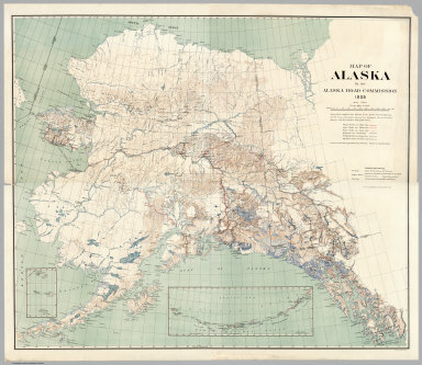
Author
United States. Alaska Road Commission
Full Title
(Composite Map to) Map of Alaska By the Alaska Road Commission. 1909. Compiled from Surveys of the Alaska Road Commission, the U.S. Coast and Geodetic Survey, U.S. Geological Survey, U.S. Army Surveys, and the Canadian Geological Survey. Drawn by Jas. H. Watson. C.E. Superintendent A.R.C. Andrew B. Graham Co., lithographers, Washington, D.C. (insets) Aleutian Islands ; (St. Lawrence, Nunivak Island, and Pribilof Islands.)
Publisher
Alaska Road Commission ; Andrew B. Graham Co.
1-6 of 6
|