Browse All

1940 Cover: Washington, Oregon, Idaho. Pocket Map (Covers to) Washington - Oregon and Idah … |

1836 Map Of The Roads, Canals & Rail Roads of … Guide Book The Traveller's Guide or Map Of The Road … |

1834 Title Page: The American Traveller; Or G … Guide Book (Title Page to) The American Traveller; … |

1834 Map Of The Roads, Canals & Rail Roads of … Guide Book The Traveller's Guide or Map Of The Road … |

1825 Covers: Pennsylvania Pocket Map (Covers to) Pennsylvania. |

1825 Pennsylvania Pocket Map Pennsylvania. |

1853 Covers: United States, Canada, Mexico, W … Pocket Map (Covers to) Map Of The United States, Ca … |

1853 United States, Canada, Mexico, West Indi … Pocket Map Map Of The United States, Canada, Mexico … |

1881 Covers: Driving Road Chart Of Westcheste … Pocket Map (Covers to) Driving Road Chart Of Westch … |

1881 Driving Road Chart Of Westchester County Pocket Map Driving Road Chart Of Westchester County … |

1848 Hudson River Guide Book Travellers' Guide of the Hudson River. P … |

1840 A new map of New York with its canals, r … Guide Book A new map of New York with its canals, r … |

1840 A new map of Pennsylvania with its canal … Guide Book A new map of Pennsylvania with its canal … |

1927 Transcontinental Highway map National Atlas Transcontinental Highway map. (Copyrigth … |

1927 Sectional paved road map National Atlas Sectional paved road map. Copyrighted by … |

1927 Sectional paved road map (Continues) National Atlas Sectional paved road map. Copyrighted by … |

1927 Sectional paved road map (Continues) National Atlas Sectional paved road map. Copyrighted by … |

1927 Sectional paved road map (Continues) National Atlas Sectional paved road map. Copyrighted by … |

1927 Sectional paved road map (Continues) National Atlas Sectional paved road map. Copyrighted by … |

1927 Sectional paved road map (Continues) National Atlas Sectional paved road map. Copyrighted by … |

1927 Sectional paved road map (Continues) National Atlas Sectional paved road map. Copyrighted by … |

1927 Sectional paved road map (Continues) National Atlas Sectional paved road map. Copyrighted by … |

1927 Sectional paved road map (Continues) National Atlas Sectional paved road map. Copyrighted by … |

1927 Sectional paved road map (Continues) National Atlas Sectional paved road map. Copyrighted by … |

1927 Maine National Atlas Maine. (Copyrighted by) National Map Com … |

1905 Theoretical diagram, Paris. City Atlas Theoretical diagram of the plan of Paris … |

1905 San Francisco, system of circuit, radial … City Atlas Plan of San Francisco, showing system of … |

1742 Carte exacte des postes et routes de l'E … World Atlas Carte exacte des postes et routes de l'E … |

1802 Post roads Germany, Hungary. World Atlas A new map of the post roads of Germany a … |

1880 Asia. World Atlas Map of Asia showing its gt. political di … |

1870 Asia. [State Atlas, World Atlas] Map of Asia showing its gt. political di … |

1909 Mendenhall's guide, road map Connecticut … Pocket Map Mendenhall's guide and road map of Conne … |

1909 Cover: Mendenhall's guide, road map Conn … Pocket Map (Covers to) Mendenhall's guide and road … |

1909 Title Page: Route guide to Mendenhall's … Pocket Map (Title Page to) Mendenhall's guide and r … |

1935 Oregon road map. Pocket Map 1935 road map Oregon. Prepared exclusive … |

1935 Western States road map. Pocket Map 1935 road map Western United States prep … |

1935 Cover: Oregon road map. Pocket Map (Covers to) 1935 road map Oregon. Prepar … |

1940 Covers: State Farm Road Atlas: United St … National Atlas (Covers to) State Farm Road Atlas: Unite … |

1940 Title Page: State Farm Road Atlas: Unite … National Atlas (Title Page to) State Farm Road Atlas: U … |

1940 Contents: State Farm Road Atlas: United … National Atlas (Contents to) State Farm Road Atlas: Uni … |

1940 Advertisement: State Farm Road Atlas: Un … National Atlas (Advertisement to) State Farm Road Atlas … |

1940 Text Page: National Parks Touring Inform … National Atlas Text Page to) National Parks Touring Inf … |

1940 Text Page: (Coninues) National Parks Tou … National Atlas Text Page to) National Parks Touring Inf … |

1940 Text Page: (Coninues) National Parks Tou … National Atlas Text Page to) National Parks Touring Inf … |

1940 Map of South and Central America National Atlas Map of South and Central America. Showin … |
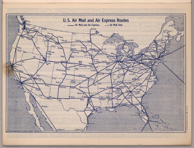
1940 U.S. Air Mail and Air Express Routes National Atlas U.S. Air Mail and Air Express Routes. Co … |

1940 Index: Index to Counties, Cities and Tow … National Atlas (Index to) Index to Counties, Cities, an … |

1940 Index:(Continues) Index to Counties, Cit … National Atlas (Index to) Index to Counties, Cities, an … |

1940 Index:(Continues) Index to Counties, Cit … National Atlas (Index to) Index to Counties, Cities, an … |

1940 Index:(Continues) Index to Counties, Cit … National Atlas (Index to) Index to Counties, Cities, an … |