Browse All
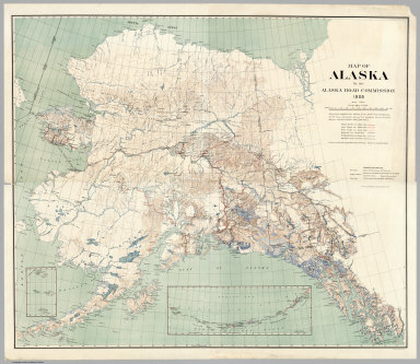
1909 Composite: Map of Alaska By the Alaska R … Separate Map (Composite Map to) Map of Alaska By the … |

1902 5. Larchmont-Kensico Sta.-Hartsdale-Gree … County Atlas Section 5. Showing from Larchmont northw … |

1902 6. Long Id. Sound-Talmadge Hill-Cos Cob- … County Atlas Section 6. Showing from Long Id. Sound n … |

1902 7. Tarrytown-Oscawana-Merritt's Corners. County Atlas Section 7. Showing from Tarrytown northw … |

1902 8. Kensico-Mt. Kisco-Pleasantville-Bedfo … County Atlas Section 8. Showing from Kensico northwar … |

1902 9. Darien-Trinity Lake-Stanwich-Wilton. County Atlas Section 9. Showing from Darien, Conn. no … |

1902 10. Croton Landing-Yorktown. County Atlas Section 10. Showing from Croton Landing … |

1902 11. Mt. Kisco-Yorktown-Cross River. County Atlas Section 11. Showing from Mount Kisco nor … |

1902 12. Trinity Lake-Ridgebury-Cross River-B … County Atlas Section 12. Showing from Trinity Lake no … |

1902 Cover: Road map Westchester Co., N.Y. County Atlas (Covers to) Servoss' sectional road map … |

1902 Title Page: Road map Westchester Co., N. … County Atlas (Title Page to) Servoss' sectional road … |

1920 Nebraska highway map. Pocket Map Highway map and guide of Nebraska. Copyr … |

1920 Cover: Nebraska highway map. Pocket Map (Covers to) Highway map and guide of Neb … |

1920 Text Page: Nebraska highway map. Pocket Map (Text Page to) Highway map and guide of … |

1963 Covers: Southern California : sunshine e … Separate Map (Covers to) Ride the roads to romance al … |

1963 Text Page: Ride the roads to romance alo … Separate Map (Text Page to) Ride the roads to romance … |

1963 Ride the roads to romance along the Gold … Separate Map Ride the roads to romance along the Gold … |

1896 Railway and highway map of the famous Be … Separate Map Railway and highway map of the famous Be … |

1953 Cover: San Francisco street map. Pocket Map (Covers to) Street map of San Francisco. … |

1953 San Francisco street map. Pocket Map Street map of San Francisco. Prepared fo … |

1953 San Francisco and vicinity. Pocket Map Map of San Francisco and vicinity prepar … |

1930 Map of North America. Karte von Nordamer … Separate Map Map of North America. Karte von Nordamer … |

1849 L'Angleterre, Galles. World Atlas Carte particuliere de l'Angleterre et de … |

1790 General Map (London Environs). National Atlas General Map (London Environs). Published … |

1790 General Plan for Trusts of the Turnpike … National Atlas General Plan for Explaining the differen … |

1790 Map Legend, and London to Hampton Court. National Atlas Explanation, Advertisement, London to Ha … |

1790 Brentford to Bagshot, Virginia Water to … National Atlas Brentford to Bagshot, Virginia Water to … |

1790 Egham to Binfield, Hounslow to Windsor. National Atlas Egham to Binfield, Hounslow to Windsor. |

1790 Colnbrook to Maidenhead, London to High … National Atlas Colnbrook to Maidenhead, London to High … |

1790 Uxbridge to Amersham. National Atlas Uxbridge to Amersham. |

1790 London to Tring. National Atlas London to Tring. |

1790 Watford to Rickmans Worth to Amersham, W … National Atlas Watford to Rickmans Worth to Amersham, W … |

1790 London to Highgate & Hampstead to Hendon … National Atlas London to Highgate & Hampstead to Hendon … |

1790 Chipping Barnet to Welwyn, London to Her … National Atlas Chipping Barnet to Welwyn, London to Her … |

1790 Hoddesdon to Ware, Potters Bar to Ware, … National Atlas Hoddesdon to Ware, Potters Bar to Ware, … |

1790 London to Chipping Ongar. National Atlas London to Chipping Ongar. |

1790 Stratford to Chelmsford. National Atlas Stratford to Chelmsford. |

1790 London to Rochester. National Atlas London to Rochester. |

1790 New Cross to Maidstone. National Atlas New Cross to Maidstone. |

1790 Lewisham to Tunbridge Wells. National Atlas Lewisham to Tunbridge Wells. |

1790 London to East Grinsted. National Atlas London to East Grinsted. |

1790 Newington to Ryegate. National Atlas Newington to Ryegate. |

1790 Tooting to Dorking. National Atlas Tooting to Dorking. |

1790 Leatherhead to Guildford, London to Guil … National Atlas Leatherhead to Guildford, London to Guil … |

1790 Hampton Court to Staines. National Atlas Hampton Court to Staines. |

1790 London to Richmond. National Atlas London to Richmond. |

1790 Covers: Cary's Survey of the High Roads … National Atlas (Covers to) Cary's Survey of the High Ro … |

1790 Title Page: Cary's Survey of the High Ro … National Atlas (Title Page to) Cary's Survey of the Hig … |

1789 Title Page: Survey of the roads of the U … Guide Book (Title Page to) A Survey of the Roads of … |

1789 From New York to Stratford. (1) Guide Book From New York to Stratford. (1) |