|
|
REFINE
Browse All : Separate Map from 1847
1-10 of 10
Author
Phelps, Humphrey
Full Title
Ornamental Map Of The United States & Mexico. 1847. Phelps' Ornamental Map Of The United States And Mexico. Entered ... 1846, by Humphrey Phelps ... New York. Published by Phelps, Ensigns & Thayer, 36 Ann Street, New York. Barritt, Sc.
Publisher
H. Phelps
Author
U.S. War Department, Topographical Engineers
Full Title
Siege Of Vera Cruz, by the U.S. Troops under Major General Scott, in March 1847, from Surveys made by Major Turnbull, Captains Hughes, McClellan & Johnston; Lieutenants Derby & Hardcastle, Topl. Engineers. Drawn by Capt. McClellan.
Publisher
No publisher
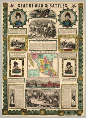
Author
Ensigns & Thayer
Full Title
Seat Of War & Battles. Map of the Seat of War. Entered ... 1847, by Ensigns & Thayer ... New York. Published By Ensigns & Thayer, 50 Ann Street, New York. And 12 Exchange St., Buffalo. Jos. Ward, 52 Cornhill St., Boston. Rufus Blanchard, Cincinnati.
Publisher
[Jos. Ward, Ensigns & Thayer ; Rufus Blanchard]
Author
Olney, Jesse, 1798-1872.
Full Title
Olney's Outline Maps, for Common Schools and General Use. United States ; Ext.2,600,000 Sq. Miles. Population 20 Mil. New York, Pratt, Woodford and Co. Entered according to Act of Congress in ... 1847, by Pratt Woodford ... Southern District of New York.
Publisher
Pratt Woodford
Author
Olney, Jesse, 1798-1872.
Full Title
Olney's Outline Maps, for Common Schools and General Use. Europe ; Extent 3 1/2 M. Sq. Miles. Population 250 M. New York, Pratt, Woodford and Co. Entered according to Act of Congress in ... 1847, by Pratt Woodford ... Southern District of New York.
Publisher
Pratt Woodford
Author
Olney, Jesse, 1798-1872.
Full Title
Olney's Outline Maps, for Common Schools and General Use. Asia ; Extent 16 M. Sq. Miles. Population 600 M. New York, Pratt, Woodford and Co. Entered according to Act of Congress in ... 1847, by Pratt Woodford ... Southern District of New York. (insets) Height of mountains ; and Palestine.
Publisher
Pratt Woodford
Author
Olney, Jesse, 1798-1872.
Full Title
Olney's Outline Maps, for Common Schools and General Use. Africa ; Extent 10 1/2 M. Sq. Miles. Population 60 M. New York, Pratt, Woodford and Co. Entered according to Act of Congress in ... 1847, by Pratt Woodford ... Southern District of New York.
Publisher
Pratt Woodford
Author
[Bruff, J. Goldsborough, Disturnell, John]
Full Title
Map Of The Valley Of Mexico and the Surrounding Mountains. New York, Published by J.Disturnell, No. 102 Broadway, 1847. Miller's Lith. 102 Broadway, N.Y. Entered ... 1847, by John Disturnell ... New York. (inset) Map of the Route between Vera Cruz, Alvarado & Puebla. (inset) Profile Of The Route Between Mexico And Vera Cruz.
Publisher
J. Disturnell
Author
Berghaus, Henry
Full Title
West Coast of South America. Peru and Bolivia ... Quilca to Cobija. Observations made on Board of H.M.S. Princess Louisa, Royal Prussian Mercantile Navy, 1827, and various Authorities by Henry Berghaus L.L.D. F.R.G.S. Regius Professor, and Principal of the geographical Institute. Potsdam, 1839. Published at the office of geogr. Institute, Potsdam, June 1, 1847. (inset) Plan of the Port of Yquique (Iquique) and principal Mines of Guantajaya; with the roads from the Port.
Publisher
Office of Geographic Institute
Author
[Barnard, J.G., Bruff, J.]
Full Title
Sketch from the mouth of the Coatzacoalcos River to the town of Mina-Titlan ; made by order of Commodore M.C. Perry. Comdg. Home Squadron. 1847. By Lieuts. Alden, Blunt & May. (inset) View of the entrance of the Coatzacoalcos River. (to accompany) Maps Illustrating The Isthmus of Tehuantepec.
Publisher
D. Appleton & Co.
1-10 of 10
|