Who What Where WhenREMOVEWHO
WHEN |
REFINE
Browse All : Separate Map from 1850
1-8 of 8
Author
U.S. War Department, Topographical Engineers
Full Title
Map Of The United States And Their Territories Between The Mississippi and the Pacific Ocean And Of Part of Mexico. Compiled in the Bureau of the Corps of Topogl. Engs. under a Resolution of the U.S. Senate. From the best authorities which could be obtained. 1850. Engraved by Sherman and Smith, New-York.
Publisher
Sherman and Smith
Author
Case Tiffany & Company
Full Title
Map of the United States. Hartd., Published By Case Tiffany & Company 1850.
Publisher
Case Tiffany & Company
Author
[Mitchell, Samuel Augustus, Dorby & Miller]
Full Title
Map Of Mexico, Including Yucatan & Upper California, exhibiting The Chief Cities And Towns, The Principal Travelling Routes &c. Philadelphia. Published by Dorby & Miller. Auburn, New York. 1850. Entered ... 1847 by S. Augustus Mitchell ... Pennsylva. (inset map) Battle Field Of Monterey.
Publisher
Dorby & Miller
Author
[Burr, David H, Haven, J.]
Full Title
The World, on Mercator's Projection: By David H. Burr. Showing the different Routes to California, and distance by each; Routes of different Navigators, Route of the contemplated Pacific R.Road, Distances to China, Europe, &c. Published by J. Haven, 86 State St. Boston; 1850. Entered ... 1850 by John Hansen ... Massachusetts. (with) two inset maps: Map of the Nicaragaua Route and A Map of the Proposed Rail Road from St. Louis To The Bay Of St. Francisco, Compiled from the Maps and Reports of Col. Fremont, by W.L. Dearborn, Civil Engineer.
Publisher
J. Haven
Author
Moore, James B.
Full Title
Chart Prepared By James B. Moore, To Accompany His Memorial To Congress Respecting the subject of Steam Communication with China, Japan &c. 1850. Engr. on Stone by H. Gollmer, Cin. (inset map) Harbour of San Francisco California.
Publisher
H. Gollmer
Author
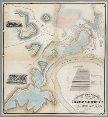
[Franks, Theo., Brady's Bend Iron Co.]
Full Title
Topographical & Geological Map Of The Property Belonging To The Brady's Bend Iron Co. Located In Armstrong County Pa. by Theo. Franks Civil Engineer. From Plan drawn by R. Jennings, Brady's Bend. Wm Schuchman, lith. 3d St, Pittsburgh, Pa. (inset) Geological Section From Notes By Prof. Shepherd.
Publisher
Wm. Schuchman lith.
Author
[Kollner, Augustus, Sunbury and Erie Railroad]
Full Title
Pennsylvania's Great Highway And Its Tributary Lines. Engraved & printed at A. Kollner's Litho Establisht. cor. of Secd. & Dock Sts. Phila.
Publisher
A. Kollner's Litho Establishment
1-8 of 8
|