Who What Where WhenREMOVEWHO
WHEN |
REFINE
Browse All : Separate Map from 1944
1-22 of 22
Author
U.S. General Land Office
Full Title
United States Department Of The Interior, Harold L. Ickes, Secretary, General Land Office, Fred W. Johnson, Commissioner. State Of California. Compiled From The Official Records Of The General Land Office And Other Sources. 1944. Compiled and drawn by T.W. Gales.
Publisher
U.S. Government
Author
U.S. General Land Office
Full Title
(Composite of) United States Department Of The Interior, Harold L. Ickes, Secretary, General Land Office, Fred W. Johnson, Commissioner. State Of California. Compiled From The Official Records Of The General Land Office And Other Sources. 1944. Compiled and drawn by T.W. Gales.
Publisher
U.S. Government
Author
USGS (U.S. Geological Survey)
Full Title
Hawthorne, Calif.-Nev.
Publisher
USGS (U.S. Geological Survey)
Author
Army Information Branch, Army Service Forces
Full Title
New Guinea, Newsmap Vol. II, No. 37, Vol. III, No. 68.
Publisher
Army Information Branch, Army Service Forces
Author
Army Information Branch, Army Service Forces
Full Title
Newsmap, Monday, January 3, 1944, Week of December 22 to December 29, 1943, 225th Week of the War - 107th Week of U.S. Participation, Vol. II, No. 37. Newsmap for the Armed Forces, 246th Week of the War - 128th Week of U.S. Participation.
Publisher
Army Information Branch, Army Service Forces
Author
[Thomas Bros., Freese, Harry]
Full Title
Commercial and school map of California ; Compiled, published and copyrighted by Harry Freese ; published and for sale by Thomas Bros. (insets) San Francisco, Oakland and vicinity. Scale 1:335,000 ; Los Angeles and vicinity. Scale 1:335,000 ; Map showing township range survey system in California.
Publisher
Thomas Bros.
Author
[Turner, Stanley, Petersen, C.C.]
Full Title
Dated Events. On To Tokyo. Map of the Pacific and the Far East. Stanley Turner, 44. Copyright, Canada and U.S.A., 1944, C.C. Petersen, Publishing and Advertising, Toronto, Canada. Seventh Edition.
Publisher
C.C. Petersen Publishing and Advertising
Author
[George Fielding, Eliot, Thompson, Kenneth, W.]
Full Title
[World War II battlefronts]. Map I, The Russian Front. Copyright, 1944, by Remington Rand, Inc. Printed in U.S.A. (Map signed by) Kenneth W. Thompson. (text signed by) George Fielding Eliot. (on lower margin) X600LB.
Publisher
Remington Rand Inc..
Author
[George Fielding, Eliot, Thompson, Kenneth, W.]
Full Title
[World War II battlefronts]. Map II, The Balkans. Copyright, 1944, by Remington Rand, Inc. Printed in U.S.A. (Map signed by) Kenneth W. Thompson. (text signed by) George Fielding Eliot. (on lower margin) X600LB.
Publisher
Remington Rand Inc..
Author
[George Fielding, Eliot, Thompson, Kenneth, W.]
Full Title
[World War II battlefronts]. Map III, Italy & South France. Copyright, 1944, by Remington Rand, Inc. Printed in U.S.A. (Map signed by) Kenneth W. Thompson. (text signed by) George Fielding Eliot. (on lower margin) X600LB.
Publisher
Remington Rand Inc..
Author
[George Fielding, Eliot, Thompson, Kenneth, W.]
Full Title
[World War II battlefronts]. Map IV. The Western Front. Copyright, 1944, by Remington Rand, Inc. Printed in U.S.A. (Map signed by) Kenneth W. Thompson. (text signed by) George Fielding Eliot. (on lower margin) X600LB.
Publisher
Remington Rand Inc..
Author
[George Fielding, Eliot, Thompson, Kenneth, W.]
Full Title
[World War II battlefronts]. Map V. Southeastern Asia. Copyright, 1944, by Remington Rand, Inc. Printed in U.S.A. (Map signed by) Kenneth W. Thompson. (text signed by) George Fielding Eliot. (on lower margin) X600LB.
Publisher
Remington Rand Inc..
Author
[George Fielding, Eliot, Thompson, Kenneth, W.]
Full Title
[World War II battlefronts]. Map VI. The Southwest Pacific. Copyright, 1944, by Remington Rand, Inc. Printed in U.S.A. (Map signed by) Kenneth W. Thompson. (text signed by) George Fielding Eliot. (on lower margin) X600LB.
Publisher
Remington Rand Inc..
Author
[George Fielding, Eliot, Thompson, Kenneth, W.]
Full Title
[World War II battlefronts]. Map VII. The North Pacific. Copyright, 1944, by Remington Rand, Inc. Printed in U.S.A. (Map signed by) Kenneth W. Thompson. (text signed by) George Fielding Eliot. (on lower margin) X600LB.
Publisher
Remington Rand Inc..
Author
[Harrison, Richard Edes, Army Information Branch, Army Service Forces]
Full Title
Europe as Viewed from the U.S.S.R. Newsmap. Monday, July 31, 1944. ... Vol. III No. 15F. Prepared and Distributed by the Army Information Branch, Army Service Forces. Navy Distribution by Educational Services Section, BuPers, Navy Dept., Washington D.C. U.S. Government Printing Office: 1944 - 591000.
Publisher
Army Information Branch, Army Service Forces
Author
[Harrison, Richard Edes, Army Information Branch, Army Service Forces]
Full Title
Newsmap. (War front near Florence, Italy. Guam, Agiguwant, Tinian and Saipan. Pacific Island Groups). Monday, July 31, 1944. ... Vol. III No. 15F. Prepared and Distributed by the Army Information Branch, Army Service Forces. Navy Distribution by Educational Services Section, BuPers, Navy Dept., Washington D.C. U.S. Government Printing Office: 1944 - 591000.
Publisher
Army Information Branch, Army Service Forces
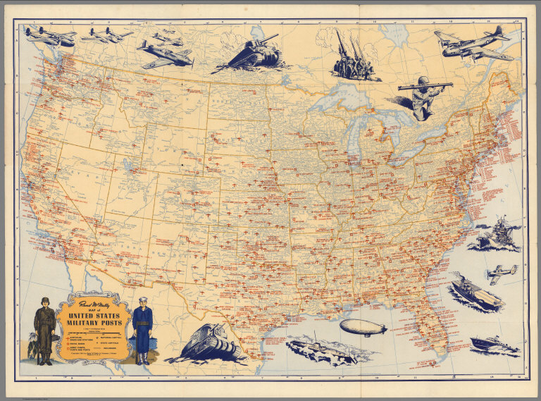
Author
Rand McNally & Co.
Full Title
Rand McNally Map of United States Military Posts.
Publisher
Rand McNally & Co.
Author
Sundberg, Edwin L.
Full Title
Our Neighbors to the South (South America), Sunday News, May 21, 1944.
Publisher
Sunday News
Author
Los Angeles Times
Full Title
Saipan conquest sets pattern for vast aerial operations. Los Angeles Times. Monday July 10, 1944.
Publisher
Los Angeles Times
Author
Rand McNally & Co.
Full Title
(Covers to) Map of United States Military Posts.
Publisher
Rand McNally & Co.
1-22 of 22
|