Browse All

1840 Nouvelle Carte du Mexique, Du Texas. Separate Map Nouvelle Carte du Mexique, Du Texas Et D … |

1839 The Coasts of Guatimala And Mexico, from … Separate Map The Coasts of Guatimala And Mexico, from … |

1850 Map of the United States. Separate Map Map Of The United States And Their Terri … |

1847 Ornamental Map Of The United States & Me … Separate Map Ornamental Map Of The United States & Me … |

1846 Ornamental Map Of The United States and … Separate Map Ornamental Map Of The United States & Me … |

1855 Ornamental Map Of The United States & Me … Separate Map Ornamental Map Of The United States & Me … |

1848 Map Of The United States And Mexico Separate Map Ornamental Map Of The United States & Me … |

1847 Siege Of Vera Cruz, by the U.S. Troops Separate Map Siege Of Vera Cruz, by the U.S. Troops u … |
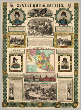
1847 Seat Of War and Battles. Map of the Seat … Separate Map Seat Of War & Battles. Map of the Seat o … |

1849 Map Of Mexico, Texas, Old And New Califo … Separate Map Map Of Mexico, Texas, Old And New Califo … |

1850 Map Of Mexico, Including Yucatan & Upper … Separate Map Map Of Mexico, Including Yucatan & Upper … |

1846 Map Of The Seat Of War Gen. Taylor's Fie … Separate Map Map Of The Seat Of War Gen. Taylor's Fie … |

1849 Map Of The United States The British Pro … Separate Map Map Of The United States The British Pro … |

1870 Carte Generale Des Etats - Unis Et Du Me … Separate Map Carte Generale Des Etats - Unis Et Du Me … |

1876 Carte Generale Des Etats - Unis Et Du Me … Separate Map Carte Generale Des Etats - Unis Et Du Me … |

1871 Topographical Map Of America 1871 Separate Map Lloyd's Topographical Map Of America 187 … |

1863 Carta General de la Republica Mexicana. Separate Map Carta General de la Republica Mexicana, … |

1948 The Americas Served by American Republic … Separate Map The Americas Served by American Republic … |

1915 Explorations on the northern frontier of … Separate Map Explorations on the northern frontier of … |
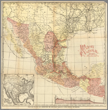
1897 Mexico National R.R. Loredo Route ... Sh … Separate Map Mexico National R.R. and Connections. |

1847 Map Of The Valley Of Mexico and the Surr … Separate Map Map Of The Valley Of Mexico and the Surr … |

1820 Map of Louisiana and Mexico (southern po … Separate Map A Map of Louisiana and Mexico (southern … |

1852 Contents: Contents: Maps Illustrating Th … Separate Map (Contents to) Contents: Maps Illustratin … |

1852 No.1. Map of the Isthmus of Tehuantepec Separate Map Map of the Isthmus of Tehuantepec, embra … |

1851 No.2. Plan of that part of the Isthmus o … Separate Map Plan of that part of the Isthmus of Tehu … |

1848 No.3. Mouth of the Coatzacoalcos River s … Separate Map Mouth of the Coatzacoalcos River surveye … |

1847 No.4. Sketch from the mouth of the Coatz … Separate Map Sketch from the mouth of the Coatzacoalc … |
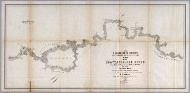
1851 No.5. Map of the Coatzacoalcos River fro … Separate Map 1851 Tehuantepec Survey, Major J.G. Barn … |

1851 No.6. Map of the River Uspanapa to the P … Separate Map Tehuantepec Survey, Maj. J.G. Barnard. U … |

1852 No.7. Chart of the ports of La Ventosa & … Separate Map Chart of the ports of La Ventosa & Salin … |

1852 No.8. Chart of the entrance and channel … Separate Map Chart of the entrance and channel of the … |

1915 Covers: Explorations on the northern fro … Separate Map (Covers to) Explorations on the Northern … |

1820 Composite: Map of Louisiana and Mexico. Separate Map (Composite of) A Map of Louisiana and Me … |