Who What Where WhenREMOVEWHO
|
REFINE
Browse All : Separate Map of Mexico
1-33 of 33
Author
Brue, Adrien Hubert, 1786-1832
Full Title
Nouvelle Carte du Mexique, Du Texas Et D'Une Partie Des Provinces Unies De L'Amerique Centrale. Dediee a l'Academie Royale des Sciences de l Institut de France. Par A.H. Brue, Geographe du Roi, Membre de la common. centrale de la societe de Geographie de Paris, membre-honoraire de celle de Londres, &a. Revue et augmentee par Ch. Picquet, Geographe du Roi et du Due d'Orleans, Proprietaire des Cartes et Atlas de Brue, Quai Conti No. 17, pres de l'Institut. Paris, 1840. Publiee en 1834; Revue en 1837, 1839, 1840 ... (with 2 inset maps).
Publisher
Charles Picquet
Author
[Arrowsmith, John, Forbes, Alexander]
Full Title
The Coasts of Guatimala And Mexico, from Panama To Cape Mendocino: with the Principal Harbours in California. 1839. London, Smith Elder & Co. 1839. John Arrowsmith. (with 6 inset maps).
Publisher
Smith Elder & Co.
Author
U.S. War Department, Topographical Engineers
Full Title
Map Of The United States And Their Territories Between The Mississippi and the Pacific Ocean And Of Part of Mexico. Compiled in the Bureau of the Corps of Topogl. Engs. under a Resolution of the U.S. Senate. From the best authorities which could be obtained. 1850. Engraved by Sherman and Smith, New-York.
Publisher
Sherman and Smith
Author
Phelps, Humphrey
Full Title
Ornamental Map Of The United States & Mexico. 1847. Phelps' Ornamental Map Of The United States And Mexico. Entered ... 1846, by Humphrey Phelps ... New York. Published by Phelps, Ensigns & Thayer, 36 Ann Street, New York. Barritt, Sc.
Publisher
H. Phelps
Author
Phelps, Humphrey
Full Title
Ornamental Map Of The United States & Mexico. 1846. Phelps' Ornamental Map Of The United States And Mexico. Entered ... 1846, by Humphrey Phelps ... New York. Published by H. Phelps No. 144 Fulton Street, near Broadway, New York. Barritt, Sc.
Publisher
H. Phelps
Author
Ensign, Bridgman & Fanning
Full Title
Ornamental Map Of The United States & Mexico. Map Of The United States And Mexico. Ensign, Bridgman & Fanning, Publishers, 156 William St. New York. Entered ... 1855, by Ensign, Bridgman & Fanning ... New York.
Publisher
Ensign, Bridgman & Fanning
Author
Ensigns & Thayer
Full Title
Ornamental Map Of The United States & Mexico. Map Of The United States And Mexico Including Oregon, Texas and the Californias. Entered ... 1848, by Ensigns & Thayer ... New York. Published by Ensign & Thayer, 50 Ann Street New York. And 12 Exchange St., Buffalo. Sowle & Ward, 43 Cornhill, Boston. Rufus Blanchard: Cincinatti.
Publisher
[Ensigns & Thayer ; Rufus Blanchard, Sowle & Ward]
Author
U.S. War Department, Topographical Engineers
Full Title
Siege Of Vera Cruz, by the U.S. Troops under Major General Scott, in March 1847, from Surveys made by Major Turnbull, Captains Hughes, McClellan & Johnston; Lieutenants Derby & Hardcastle, Topl. Engineers. Drawn by Capt. McClellan.
Publisher
No publisher
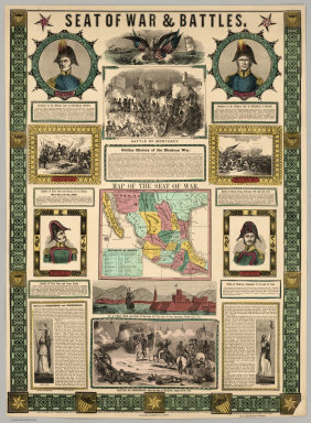
Author
Ensigns & Thayer
Full Title
Seat Of War & Battles. Map of the Seat of War. Entered ... 1847, by Ensigns & Thayer ... New York. Published By Ensigns & Thayer, 50 Ann Street, New York. And 12 Exchange St., Buffalo. Jos. Ward, 52 Cornhill St., Boston. Rufus Blanchard, Cincinnati.
Publisher
[Jos. Ward, Ensigns & Thayer ; Rufus Blanchard]
Author
House & Brown
Full Title
Map Of Mexico, Texas, Old And New California, And Yucatan. Showing the principal Cities and Towns, Travelling Routes &c. Hartford: Published By House & Brown. 1849. Entered ... 1847 by House & Brown ... (inset map) Plan Of Operations At The Battle Of Monterey On The 21st, 22nd, & 23rd Sept. 1846. (inset) Map Of Vera Cruz And San Juan De Ulloa. (Lith. Of E.B.) & E.C. Kellogg, Hartford, Conn.
Publisher
House & Brown
Author
[Mitchell, Samuel Augustus, Dorby & Miller]
Full Title
Map Of Mexico, Including Yucatan & Upper California, exhibiting The Chief Cities And Towns, The Principal Travelling Routes &c. Philadelphia. Published by Dorby & Miller. Auburn, New York. 1850. Entered ... 1847 by S. Augustus Mitchell ... Pennsylva. (inset map) Battle Field Of Monterey.
Publisher
Dorby & Miller
Author
Mitchell, Samuel Augustus
Full Title
Map Of The Seat Of War Gen. Taylor's Field Of Operations In Mexico. Philadelphia. Pubd. by S. Augustus Mitchell, N.E. Corr. of Market & 7th Sts. ... (inset map) The Late Battlefield. (inset) Map of the Seat Of War.
Publisher
S.A. Mitchell
Author
Colton, J.H.
Full Title
Map Of The United States The British Provinces Mexico &c. Showing the Routes of the U.S. Mail Steam Packets to California, and a Plan of the Gold Region. Published By J.H. Colton, 86 Cedar St. New York. 1849. Drawn & Engraved by J.M. Atwood. New York. Entered ... 1849, by J.H. Colton ... New York. (inset) Map Of The Gold Region. California. (untitled inset of South America; From New York to San Francisco via Cape Horn...).
Publisher
J.H. Colton
Author
Andriveau-Goujon, E.
Full Title
Carte Generale Des Etats - Unis Et Du Mexique, Comprenant L'Amerique Centrale Et Les Antilles. E. Andriveau-Goujon, Editeur. Paris, Rue Du Bac, 21. Nouvelle Edition. 1870. (with four inset maps).
Publisher
Andriveau-Goujon
Author
Andriveau-Goujon, E.
Full Title
Carte Generale Des Etats - Unis Et Du Mexique, Comprenant L'Amerique Centrale Et Les Antilles. E. Andriveau-Goujon, Editeur. Paris, Rue Du Bac, 4. Nouvelle Edition. 1876. (with four inset maps).
Publisher
Andriveau-Goujon
Author
[Lloyd, James T., Lloyd, E.]
Full Title
Lloyd's Topographical Map Of America 1871. Projected By J.T. Lloyd. E. Lloyd, Publisher, New York, Cortlandt St., London, 83 Fleet St. Entered ... 1865 by J.T. Lloyd ... New York ...
Publisher
E. Lloyd
Author
Garcia Cubas, Antonio, 1832-1912
Full Title
Carta General de la Republica Mexicana, formada por Antonio Garcia y Cubas
Publisher
H. Iriarte y Ca.
Author
Thompson, Kenneth W.
Full Title
The Americas Served by American Republic Lines ; Grace Line ; Pan American Airways System Pan American-Grace Airways ; United Fruit Company. (by) Kenneth W. Thompson. Printed in U.S.A.
Publisher
No publisher
Author
Bolton, Herbert Eugene, 1870-1953.
Full Title
Explorations on the northern frontier of New Spain 1535-1706 : compiled by Herbert Bolton 1915 ; H.B. Foster, del.
Publisher
University of California Press
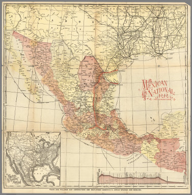
Author
Mexico National R.R.
Full Title
Mexico National R.R. and Connections.
Publisher
Mexico National R.R.
Author
[Bruff, J. Goldsborough, Disturnell, John]
Full Title
Map Of The Valley Of Mexico and the Surrounding Mountains. New York, Published by J.Disturnell, No. 102 Broadway, 1847. Miller's Lith. 102 Broadway, N.Y. Entered ... 1847, by John Disturnell ... New York. (inset) Map of the Route between Vera Cruz, Alvarado & Puebla. (inset) Profile Of The Route Between Mexico And Vera Cruz.
Publisher
J. Disturnell
Author
[Tardieu, P.F., Tardieu, P. (Pierre Antoine), 1784-1869]
Full Title
A Map of Louisiana and Mexico (southern portion). Carte de la Louisiane et du Mexique, Dressee par P. Tardieu fils aine, Gravee par P.A.F. Tardieu pere. Paris 1820. A Paris, chez: P.A.F. Tardieu, Place de l'Estrapade No. 34. C. Piequet, Geographe Graveur, Quai Conti No. 17. J. Goujon, Marchand de Cartes Geographiques, Rue du Bac No. 6. New York. Anthy. Girard , Mercht. Agent for the Author. Ecrit par Richomme.
Publisher
J. (Jean) Goujon, 1793-1826
Author
[Barnard, J.G., Bruff, J.]
Full Title
(Contents to) Contents: Maps Illustrating The Isthmus of Tehuantepec. New York: D. Appleton & Company, 200 Broadway. M DCCC LII (1852). (on verso) Entered ... 1852, by B. Fallon ... Louisiana.
Publisher
D. Appleton & Co.
Author
[Barnard, J.G., Bruff, J.]
Full Title
Map of the Isthmus of Tehuantepec, embracing all the surveys of the engineering & hydrographic parties, and shewing the proposed route of the Tehuantepec Rail Road; surveyed under the direction of Maj. J.G. Barnard U.S. Engrs.. Chief Engineer 1851. Drawn by Chas. C. Smith. Lith. of Sarony & Major, New York. Entered ... 1852, by B. Fallon ... in the court of Southern District of New York. (inset) Profile of the Rail Road from Minatitlan to La Ventosa. (to accompany) Maps Illustrating The Isthmus of Tehuantepec.
Publisher
D. Appleton & Co.
Author
[Barnard, J.G., Bruff, J.]
Full Title
Plan of that part of the Isthmus of Tehuantepec between the Jaltepec River and the Pacific Plains, embracing all of the engineering difficulties on the route of survey. J.G. Barnard. U.S.Engineers, Chief Engineer. J. J. Williamd 1st. Assistant. J. C. Avery 2nd. Lith. of Endicott & Co. N.Y. Entered ... by B. Fallon ... in the court of Southern District of New York. (inset) Profile of the lines as surveyed 1851. (to accompany) Maps Illustrating The Isthmus of Tehuantepec.
Publisher
D. Appleton & Co.
Author
[Barnard, J.G., Bruff, J.]
Full Title
Mouth of the Coatzacoalcos River surveyed Jan. 1848 by order of Com. M.C. Perry. By ... officers of the U.S. Brig Stromboli. Engraved by Sherman & Smith, N.Y. (to accompany) Maps Illustrating The Isthmus of Tehuantepec.
Publisher
D. Appleton & Co.
Author
[Barnard, J.G., Bruff, J.]
Full Title
Sketch from the mouth of the Coatzacoalcos River to the town of Mina-Titlan ; made by order of Commodore M.C. Perry. Comdg. Home Squadron. 1847. By Lieuts. Alden, Blunt & May. (inset) View of the entrance of the Coatzacoalcos River. (to accompany) Maps Illustrating The Isthmus of Tehuantepec.
Publisher
D. Appleton & Co.
Author
[Barnard, J.G., Bruff, J.]
Full Title
1851 Tehuantepec Survey, Major J.G. Barnard. U.S.Engineers, Engineer in Chief. Map of the Coatzacoalcos River from Mina-titlan to the Isla del Suchil and of the Jaltepec River from its junction to the railroad crossing. Surveyed by the Hydrographic party under the command of Wm. G. Temple. Passd. Midn. U.S.N. and Chief Hydroge. Asst. Drawn by Louis R.O. Townsend. Lith. of Sarony & Major 117, Fulton St. New York. Entered ... 1852 by B. Fallon ... in the court of Sn. Desct. of New York. (to accompany) Maps Illustrating The Isthmus of Tehuantepec.
Publisher
D. Appleton & Co.
Author
[Barnard, J.G., Bruff, J.]
Full Title
Tehuantepec Survey, Maj. J.G. Barnard. U.S.Engineers, Engineer in Chief. Map of the River Uspanapa to the Playa del Tigre. Made in May 1851 by J.Mc.L. Murphy U.S.N. Hydrographic Assistnt. Lith. of Sarony & Major 117, Fulton St. N.Y. Entered ... 1852 by B. Fallon ... in the court of Sn. Dct. of New York. (insets) Map of the Tancochapa River, from the Hacienda of San Jose to la Isla de Xucuapa. 1851. Map of the Village of Mina-Titlan. Surveyed and drawn by Chas. C. Smith. 1851. (to accompany) Maps Illustrating The Isthmus of Tehuantepec.
Publisher
D. Appleton & Co.
Author
[Barnard, J.G., Bruff, J.]
Full Title
Chart of the ports of La Ventosa & Salina Cruz according to the survey made in December 1850 ; for the Tehuantepec Rail Road Company, New Orleans, by their engineer P.E. Trastour. New Orlean October 11th. 1851. Engr. by J. Schedler. Lith. of Sarony & Major. 117 Fulton St. N.Y. Entered ... 1852 by B. Fallon ... in the court of Sn. Desct. of New York. (to accompany) Maps Illustrating The Isthmus of Tehuantepec.
Publisher
D. Appleton & Co.
Author
[Barnard, J.G., Bruff, J.]
Full Title
Chart of the entrance and channel of the Boca-Barra, according to the survey made in November 1850 for the Tehuantepec Rail Road Company of New Orleans by their engineer P.E. Trastour. Lith. of Endicott & Co. N.Y. Entered ... by B. Fallon ... in the court of Southern. Dist. of N. Y. (to accompany) Maps Illustrating The Isthmus of Tehuantepec.
Publisher
D. Appleton & Co.
Author
Bolton, Herbert Eugene, 1870-1953.
Full Title
(Covers to) Explorations on the Northern Frontier of New Spain 1535-1706 : compiled by Herbert Bolton : University of California Press : November, 1915; Price 10 cents. (at head of title) University of California Map Series, No.1.
Publisher
University of California Press
Author
[Tardieu, P.F., Tardieu, P. (Pierre Antoine), 1784-1869]
Full Title
(Composite of) A Map of Louisiana and Mexico. Carte de la Louisiane et du Mexique, Dressee par P. Tardieu fils aine, Gravee par P.A.F. Tardieu pere. Paris 1820. A Paris, chez: P.A.F. Tardieu, Place de l'Estrapade No. 34. C. Piequet, Geographe Graveur, Quai Conti No. 17. J. Goujon, Marchand de Cartes Geographiques, Rue du Bac No. 6. New York. Anthy. Girard , Mercht. Agent for the Author. Ecrit par Richomme.
Publisher
J. (Jean) Goujon, 1793-1826
1-33 of 33
|