Who What Where WhenREMOVEWHERE
|
Author
U.S. General Land Office
Full Title
A Diagram of Oregon. Surveyor General's Office, Eugene City, August 24th, 1863. B J Pengra;, Sur. Genl. of Oregon. Lith of J. Bien. (to accompany ten issues of) A Diagram of Oregon (1851,52,55,58,59,60,61,63,64).
Publisher
J. Bien.
Author
U.S. General Land Office
Full Title
A Diagram of Oregon. Lith. of J. Bien. (to accompany ten issues of) A Diagram of Oregon (1851,52,55,58,59,60,61,63,64).
Publisher
J. Bien.
Author
U.S. General Land Office
Full Title
Map of Public Surveys in Nevada Territory : to Accompany Report of Surveyor Genl. 1862. Surveyor General's Office, San Francisco, California, October 1st., 1862. E.F. Beale, U.S. Survr. Genl. Nevada Terry.
Publisher
Surveyor General
Author
U.S. General Land Office
Full Title
Map of a Part of the Territory of Washington : to Accompany Report of Surveyor General. 1855. Surveyor General's Office, Olympia, Washington Territory, September 20th, 1855 James Tilton, Surveyor General. Lith. by A. Hoen & Co. Balto.
Publisher
A. Hoen & Co.
Author
U.S. General Land Office
Full Title
Map of a Part of Washington Territory Lying East of the Cascade Mountains : to Accompany Report of Surveyor General. 1857. Surveyor General's Office, Olympia, W. T. September 21st., 1857. James Tilton, Surveyor General.C.B. Graham Lith. Washington D.C.
Publisher
C.B. Graham
Author
U.S. General Land Office
Full Title
Map of a That Part of Washington Territory Lying West of the Cascade Mountains : to Accompany Report of Surveyor General. 1857. Surveyor General's Office, Olympia, W. T. September 21st., 1857. James Tilton, Surveyor General. Wagner & McGuigan Lith. Philadelphia.
Publisher
Wagner & McGuigan
Author
U.S. General Land Office
Full Title
Map of a That Part of Washington Territory Lying West of the Rocky Mountains : to Accompany Report of Surveyor General. 1858. Surveyor General's Office, Olympia, W. T. Septr. 1st., 1858. James Tilton, Surveyor General.
Publisher
U.S. General Land Office
Author
U.S. General Land Office
Full Title
Map of a Part of Washington Territory : to Accompany the Report of the Surveyor General 1859. James Tilton, Surveyor General's Office. Surveyor Genl. W.T. Olympia W.T. 1st. Septr. 1859. Lith. of J. Bien, 60 Fulton Street, N.Y.
Publisher
J. Bien
Author
U.S. General Land Office
Full Title
Map of a Part of Washington Territory : to Accompany the Report of the Surveyor General 1860-61. James Tilton, Surveyor General's Office. Surveyor Genl. W.T. Olympia W.T. Sept. 20th., 1860. Lith. of J. Bien, 80 Broadway, N.Y.
Publisher
J. Bien
Author
U.S. General Land Office
Full Title
Map of a Part of Washington Territory : to Accompany the Report of the Surveyor General 1861. James Tilton, Surveyor General Office. Olympia W.T. Sept. 9th., 1861. Sheet No. 2. James Tilton Surveyor General's Office, Olympia, W.T.
Publisher
U.S. General Land Office
Author
U.S. General Land Office
Full Title
Map of Public Surveys in the Territory of Washington, for the Report of the Surv : Genl : 1862. Surveyor General Office, Olympia W.T. August 30. 1862. Anson G. Henry, surveyor General. Lith. of J. Bien, 24 Vesey St, N.Y.
Publisher
J. Bien
Author
U.S. General Land Office
Full Title
Map of Public Surveys, Washington Territory : to Accompany Report of Surv: Genl: 1863. Surveyor General Office, Olympia W.T. August 30. 1863. Anson G. Henry. Surveyor General. Lith. of J. Bien, 24 Vesey St., N.Y.
Publisher
Julius Bien
Author
U.S. General Land Office
Full Title
Territory of Washington. Department of the Interior, General Land Office, J. A. Williamson, Commissioner. Compiled from the Official Records of the General Land Office and Other Sources by C. Roeser, Principal Draughtsman G.L.O. Photo Lith & print by Julius Bien, 16 & 18 Park Place, N.Y.
Publisher
J. Bien
Author
[Wallen, Henry Davies, 1819-1886, Dixon, Joseph H]
Full Title
Map Exhibiting The Routes between Fort Dalles And The Great Salt Lake. By Bvt. 2d Lieut. Joseph Dixon Topl. Engrs. From Explorations made by him while attached to the Wagon Road Expedition to the Valley of the Great Salt Lake under the command of Capt. H.D. Wallen 4th Infy. Compiled under the direction of Capt. Geo. Thom, Topl. Engrs. from the orders of Brig. Gen. W.S. Harney Commanding The Department Of Oregon. 1859. "Copy" Bureau of Topog. Engineers, November 9th 1860. Lith. of J. Bien, 180 Broadway N.Y.
Publisher
[J. Bien, U.S.]
Author
[U.S. Department of the Interior, Hayden, F. V. (Ferdinand Vandeveer), 1829-1887]
Full Title
Lower Geyser Basin Fire Hole River Wyoming Territory. Department Of The Interior U.S. Geological Survey Of The Territories. Surveyed by the Party in charge of F.V. Hayden U.S. Geologist 1871. Compiled and drawn from field notes and sketches of A. Schonborn by E. Hergesheimer.
Publisher
J. Bien
Author
Hayden, F.V.
Full Title
Montana And Wyoming Territories. Embracing most of the country drained by the Madison, Gallatin And Upper Yellowstone Rivers. Department Of The Interior U.S. Geological Survey Of The Territories. F.V. Hayden, U.S. Geologist In Charge. Geology By F.V. Hayden, Assisted By A.C. Reale, Drawn By Henry Gannett, From Notes And Sketches By Adolf Burck, Chief Topographer Of The Yellowstone Division. J. Bien, Lith.
Publisher
[U.S. Geological Survey of the Territories, J. Bien]
Author
Jones, William A.
Full Title
Map Of The Military Department of the Platte. Wyoming. Sheet No. 3. Compiled under the direction of Captain Wm. A. Jones Corps of Engineers; Omaha Nebraska. 1874. Drawn by Louis von Froben.
Publisher
U.S. Army
Author
Jones, William A.
Full Title
Sheet No. 3. Campaign Map of the Department Of The Platte Comprising that Portion of Nebraska & Wyoming Lying between Long. 103-106 and Lat. 41-45 Compiled under the direction of Captain W.A. Jones Corps of Engrs. U.S.A. 1874. Published by authority of the Hon. Secretary of War in the Office of the Chief of Engineers U.S. Army.
Publisher
U.S. Army
Author
Jones, William A.
Full Title
Sheet No. 4. Campaign Map of the Department Of The Platte Comprising that portion of Wyoming Lying between Long. 106-109 and Lat. 41-45 Compiled under the direction of Captain W.A. Jones Corps of Engrs. U.S.A. 1874. Published by authority of the Hon. Secretary of War in the Office of the Chief of Engineers U.S. Army. N. Peters, Photo-Lithographer, Washington, D.C.
Publisher
U.S. Army
Author
Jones, William A.
Full Title
Map Of Military Department of the Platte. Nebraska. Sheet No. 2. Compiled under the direction of Captain W.A. Jones Corps of Engineers; Omaha Nebraska. 1872. Published by authority of the Hon. Secretary of War in the Office of the Chief of Engineers U.S. Army. N. Peters, Photo-Lithographer, Washington, D.C.
Publisher
U.S. Army
Author
Phelps, Humphrey
Full Title
The Unanimous Declaration Of The Thirteen United States of America. In Congress July 4th, 1776 ... Published and For Sale by Humphrey Phelps, No. 144 Fulton St., near Broadway, N. York. Entered ... 1845, by H. Phelps ... New York. Barritt, Sc.
Publisher
H. Phelps
Author
U.S. General Land Office
Full Title
Department Of The Interior General Land Office J.A. Williamson, Commissioner. State of Mississippi. 1878. Compiled from the official Records of the General Land Office and other sources by C. Roeser, Principal Draughtsman G.L.O. Photo lith & print by Julius Bien 16 & 18 Park Place N.Y.
Publisher
Julius Bien
Author
[Hood, Washington, Poinsett, J.R.]
Full Title
Map Illustrating the Plan of the Defenses of the Western & North-Western Frontier, as Proposed by The Hon: J.R. Poinsettt, Sec. Of War, in his report of Dec. 30, 1837. Compiled in the U.S. Topographical Bureau under the Direction of Col. J.J. Abert, U.S.T.E. By W. Hood.
Publisher
U.S.
Author
[Hood, Washington, Gratiot, Charles]
Full Title
Map Illustrating the plan of the defenses of Western & North-Western Frontier, as proposed by Charles Gratiot, in his report of Oct. 31, 1837. Compiled in the U.S. Topographical Bureau under the direction of Col. J.J. Abert, U.S.T.E. By W. Hood.
Publisher
U.S.
Author
Phelps, Humphrey
Full Title
Ornamental Map Of The United States & Mexico. 1847. Phelps' Ornamental Map Of The United States And Mexico. Entered ... 1846, by Humphrey Phelps ... New York. Published by Phelps, Ensigns & Thayer, 36 Ann Street, New York. Barritt, Sc.
Publisher
H. Phelps
Author
Phelps, Humphrey
Full Title
Ornamental Map Of The United States & Mexico. 1846. Phelps' Ornamental Map Of The United States And Mexico. Entered ... 1846, by Humphrey Phelps ... New York. Published by H. Phelps No. 144 Fulton Street, near Broadway, New York. Barritt, Sc.
Publisher
H. Phelps
Author
U.S. War Department
Full Title
Map of the States of Kansas and Texas and Indian Territory with Parts of the Territories of Colorado and New Mexico (North half sheet only).
Publisher
Julius Bien
Author
Haven, John
Full Title
Map Of The United States And Mexico, Including Oregon, Texas And The Californias.
Publisher
No. publisher
Author
[Mallery, J.C., Ward, J.W.]
Full Title
Sheet No. 1 & 3, Department of Arizona. Revised, 1875. Compiled under the authority of Maj. Gen. J.M. Schofield Commanding Mil. Div. of the Pacific by 1st Lieut. J.C. Mallery Corps of Engrs. Published by authority of The Hon. The Secretary of War in the Office of the Chief Of Engineers U.S. Army Washington D.C. 1876. Drawn by J.W. Ward ...
Publisher
U.S.
Author
[Warren, G.K., (Evans, Elwood)]
Full Title
Map Of The Military Dep't Of Oregon. Office Explns. And Surveys. War Dep't. Being a Section of the Map of the Territory of the U.S. from the Mississippi River to the Pacific Ocean, Compiled from all the reliable data. By Lt. G.K. Warren, T.E. under the direction of Capt. A.A. Humphreys, T.E. 1858.
Publisher
War Dept., Office of Explorations and Surveys
Author
Duval, P.S. and Son
Full Title
Military Map Of The United States & Territories Showing The Location of the Military Posts, Arsenals, Navy Yards, & Ports of Entry. Compiled from Pub - Doc - 1861. Published by P.S. Duval & Son. Nos. 22&24 South 5th St. Philada. Entered ... 1861 by P.S. Duval & Son ... Penna. (inset) Pensacola & Perdido Bays. (untitled inset map of Key West).
Publisher
P.S. Duval & Son
Author
Ensign, Bridgman & Fanning
Full Title
Ornamental Map Of The United States & Mexico. Map Of The United States And Mexico. Ensign, Bridgman & Fanning, Publishers, 156 William St. New York. Entered ... 1855, by Ensign, Bridgman & Fanning ... New York.
Publisher
Ensign, Bridgman & Fanning
Author
Ensigns & Thayer
Full Title
Ornamental Map Of The United States & Mexico. Map Of The United States And Mexico Including Oregon, Texas and the Californias. Entered ... 1848, by Ensigns & Thayer ... New York. Published by Ensign & Thayer, 50 Ann Street New York. And 12 Exchange St., Buffalo. Sowle & Ward, 43 Cornhill, Boston. Rufus Blanchard: Cincinatti.
Publisher
[Ensigns & Thayer ; Rufus Blanchard, Sowle & Ward]
Author
[Kensett, T., Shelton, W.]
Full Title
An Improved Map of the United States By Shelton & Kensett. Copy right secured & entered according to Act of Congress July 6th 1813. Engraved by A. Doolittle New Haven & T. Kensett Cheshire.
Publisher
Shelton & Kensett
Author
U.S. War Department, Topographical Engineers
Full Title
Siege Of Vera Cruz, by the U.S. Troops under Major General Scott, in March 1847, from Surveys made by Major Turnbull, Captains Hughes, McClellan & Johnston; Lieutenants Derby & Hardcastle, Topl. Engineers. Drawn by Capt. McClellan.
Publisher
No publisher
Author
Haven, John
Full Title
Map Of The United States And Mexico, Including Oregon, Texas And The Californias.
Publisher
No. publisher
Author
[Disturnell, John, Colton, J.H.]
Full Title
Map Of North America From The Latest Authorities Showing the Proposed Railroad Routes from the Atlantic to the Pacific Oceans. J.H. Colton & Co. New York, 1854, for J. Disturnell. Entered ... 1849, by J.H. Colton ... New York.
Publisher
J.H. Colton & Co. for J. Disturnell
Author
U.S. General Land Office
Full Title
Department Of The Interior General Land Office J.A. Williamson, Commissioner. State of Indiana. 1878. Compiled from the official Records of the General Land Office and other sources by C. Roeser, Principal Draughtsman G.L.O. Photo lith & print by Julius Bien 16 & 18 Park Place N.Y.
Publisher
Julius Bien
Author
[Wentworth, Horace, (Case Tiffany]
Full Title
Map of the United States. Published By Horace Wentworth, 86 Washington Str. Boston. 1852.
Publisher
Horace Wentworth
Author
Williams, Henry T.
Full Title
Williams' New Trans-Continental Map Of The Pacific R.R. And Routes Of Overland Travel To Colorado, Nebraska, The Black Hills, Utah, Idaho, Nevada, Montana, California And The Pacific Coast. Henry T. Williams, Publisher 46 Beekman St. N.Y. Entered ... 1877 by H.T. Williams ... Washington. Am. Photo-Litho. Co. N.Y. (Osborne's Process.)
Publisher
Henry T. Williams
Author
Case Tiffany & Company
Full Title
Map of the United States. Hartd., Published By Case Tiffany & Company 1850.
Publisher
Case Tiffany & Company
Author
Chisholm, C.R.
Full Title
Chisholm's Railway Map Of The United States And Canada. Published By C.R. Chisholm & Bros., Railway General News Agents, 162 St. James Street, Montreal. Fisk & Russell, Engravers, New York. (inset) Eastern Part Of Massachusetts.
Publisher
C.R. Chisholm & Bros.
Author
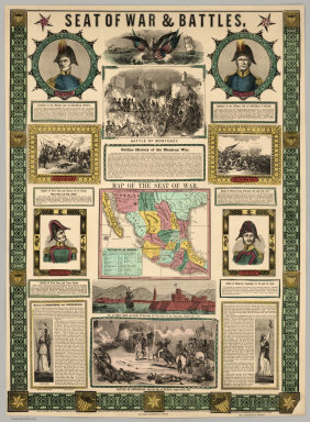
Ensigns & Thayer
Full Title
Seat Of War & Battles. Map of the Seat of War. Entered ... 1847, by Ensigns & Thayer ... New York. Published By Ensigns & Thayer, 50 Ann Street, New York. And 12 Exchange St., Buffalo. Jos. Ward, 52 Cornhill St., Boston. Rufus Blanchard, Cincinnati.
Publisher
[Jos. Ward, Ensigns & Thayer ; Rufus Blanchard]
Author
(U.S. War Department) Office of the Chief of Engineers, U.S.A.
Full Title
Southwestern New Mexico. Published by the Office Of The Chief Of Engineers, U.S.A., 1883. Drawn by W. Kilp, Top. Asst. Office of the Chief Engineer; Department of the Missouri, 1883. Official Copy, O.M. Caiter ...
Publisher
U.S. Army
Author
American Photo Lithographic Company
Full Title
The Great Railroad Routes To The Pacific, And Their Connections. 1869. American Photo-Lithographic Company, New York, (Osborne's Process).
Publisher
American Photo Lithographic Company
Author
Wilkinson, Robert
Full Title
North America, Published the 12th of August 1824. By R. Wilkinson, No.125, Fenchurch Street, London. Republished, by William Darton; 58, Holborn Hill, 3. Jany. 1826. E. Bourne, Sculp.
Publisher
William Darton
Author
Case Tiffany & Company
Full Title
Map of the United States. Hartd., Published By Case Tiffany & Company 1853.
Publisher
Case Tiffany & Company
Author
[Kensett, T., Shelton, W.]
Full Title
An Improved Map of the United States By Shelton & Kensett. Copy right secured & entered according to Act of Congress Nov. 8th 1813.
Publisher
Shelton & Kensett
|