Who What Where WhenREMOVEWHERE
|
Author
[Irrigation Districts Association of California, Imagineers '68' Burton]
Full Title
California Water Resources Developments. Issued by Irrigation Districts Association of California, Water News and Information Program.
Publisher
Irrigation Districts Association of California
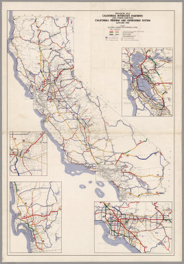
Author
California Department of Transportation, Division of Highways
Full Title
Progress Map, California Interstate Highways and Other Portions, California Freeway and Expressway System, May 1962.
Publisher
California Department of Transportation, Division of Highways
Author
Warren, Gouverneur Kemble, 1830-1882
Full Title
Map Of The Territory Of The United States From The Mississippi To The Pacific Ocean Ordered by the Hon. Jeff'n Davis, Secretary Of War To accompany the Reports of the Explorations For A Railroad Route ... Compiled from authorized explorations and other reliable data by Lieut. G.K. Warren, Topl. Engrs. In the Office of Pacific R.R. Surveys, War Dep. under the direction of Bvt. Maj. W.H. Emory and Capt. A.A. Humphreys, Topl. Engrs. 1855. Engr. by Selmar Siebert.
Publisher
U.S.
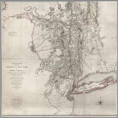
Author
[Sauthier, Claude Joseph, Faden, William]
Full Title
A Chorographical Map Of The Province Of New-York In North America, Divided into Counties, Manors, Patents and Townships; Exhibiting likewise all the private Grants of Land made and located in that Province; Compiled from Actual Surveys deposited in the Patent Office at New York, by Order of His Excellency Major General William Tryon, By Claude Joseph Sauthier Esqr. London: Engraved and Published by William Faden, (Successor to the late Thos. Jefferys Geogr. to the King) Charing-Cross. January 1st 1779 ...
Publisher
William Faden
Author
Bancroft, A.L.
Full Title
Bancroft's Map Of California, Nevada, Utah And Arizona. Published By A.L. Bancroft & Compy. Booksellers & Stationers, San Francisco, Cal. 1871. Entered ... by A.L. Bancroft & Company ... Washington, D.C.
Publisher
A.L. Bancroft
Author
[Freyhold, Edward, Warren, Gouverneur Kemble, 1830-1882]
Full Title
Map Of The Territory Of The United States From The Mississippi To The Pacific Ocean; Ordered by the Hon. Jeff'n Davis, Secretary Of War To accompany the Reports of the Explorations For A Railroad Route ... Compiled from authorized explorations and other reliable data by Lieut. G.K. Warren, Topl. Engrs. In the Office of Pacific R.R. Surveys, War Dep. under the direction of Bvt. Maj. W.H. Emory, Topl. Engrs. in 1854 and of Capt. A.A. Humphreys, Topl. Engrs. 1854-5-6-7-8. Drawn by E. Freyhold. Engr. on Stone by J. Bien, 60 Fulton St. N.Y.
Publisher
U.S.
Author
[U.S. North West Boundary Survey, Campbell, Archibald]
Full Title
Sheet No. 1. Photo-Lithographic Copy Of The Detailed Maps Of The North West Boundary ...Between The United States And The British Possessions Under the Treaty of June 15th 1846. (A-kwote-katl-nam Lake to Kootenay River, Washington Territory and British Columbia).
Publisher
Julius Bien
Author
[U.S. North West Boundary Survey, Campbell, Archibald]
Full Title
Sheet No. 2. Photo-Lithographic Copy Of The Detailed Maps Of The North West Boundary ...Between The United States And The British Possessions Under the Treaty of June 15th 1846. (Kootenay River to Camp Kootenay W., Washington Territory and British Columbia).
Publisher
Julius Bien
Author
[U.S. North West Boundary Survey, Campbell, Archibald]
Full Title
Sheet No. 3. Photo-Lithographic Copy Of The Detailed Maps Of The North West Boundary ...Between The United States And The British Possessions Under the Treaty of June 15th 1846. (Camp Kootenay W. to Camp Columbia and Yome-tsin Creek, Washington Territory and British Columbia).
Publisher
Julius Bien
Author
[U.S. North West Boundary Survey, Campbell, Archibald]
Full Title
Sheet No. 4. Photo-Lithographic Copy Of The Detailed Maps Of The North West Boundary ...Between The United States And The British Possessions Under the Treaty of June 15th 1846. (Little Dalles and Yome-tsin Creek to Rock Creek, Washington Territory and British Columbia).
Publisher
Julius Bien
Author
[U.S. North West Boundary Survey, Campbell, Archibald]
Full Title
Sheet No. 5. Photo-Lithographic Copy Of The Detailed Maps Of The North West Boundary ...Between The United States And The British Possessions Under the Treaty of June 15th 1846. (Camp O-so-yoos and O-so-yoos Lake to Camp Pa-say-ten, Washington Territory and British Columbia).
Publisher
Julius Bien
Author
[U.S. North West Boundary Survey, Campbell, Archibald]
Full Title
Sheet No. 6. Photo-Lithographic Copy Of The Detailed Maps Of The North West Boundary ...Between The United States And The British Possessions Under the Treaty of June 15th 1846. (Camp Pa-say-ten to Chiloweyuck River, Washington Territory and British Columbia).
Publisher
Julius Bien
Author
[U.S. North West Boundary Survey, Campbell, Archibald]
Full Title
Sheet No. 7. (Sheet with Title). Photo-Lithographic Copy Of The Detailed Maps Of The North West Boundary ...Between The United States And The British Possessions Under the Treaty of June 15th 1846. (Chiloweyuck River to Point Roberts, Washington Territory and British Columbia).
Publisher
Julius Bien
Author
[Raynolds,W.F., Maynadier, H.E., Gillespie,G.]
Full Title
War Department Map Of The Yellowstone And Missouri Rivers And Their Tributaries explored by Capt. W.F. Raynolds Topl. Engrs. and 1st Lieut. H.E. Maynadier 10th Infy. Assistant. 1859-60. Revised and Enlarged by Major G.L. Gillespie ... 1876 ... Published by the authority of the Hon. the Secretary Of War Office of the Chief Of Engineers, U.S. Army. 1876. Engraved in the Office of the Chief of Engineers. Western Sheet Map Of Yellowstone And Missouri Rivers ... 1877.
Publisher
U.S. War Dept.
Author
U.S. General Land Office
Full Title
A Diagram of a Portion of Oregon Territory. Surveyor General's Office, Oregon City, October 21st, 1852. Surveyor General, J B Preston. Lith. by A. Hoen & Co. Balto.
Publisher
A. Hoen
Author
[Warren, G.K., U. S. Army. Corps of Engineers]
Full Title
Map Of Nebraska And Dakota, And Portions Of The States And Territories Bordering Thereon, Compiled By Bv't Maj. Gen. G.K. Warren, Maj. Engineers. March, 1867 ... Engineer Dep't U.S. Army. Bv't Maj. Gen. A.A. Humphreys, Chief Of Engineers.
Publisher
U.S. Army Engineers
Author
Burr, David H.
Full Title
Map of the United States, Exhibiting the Several Collection Districts. Senate Ex. Doc. No. 77. Drawn by David H. Burr. Draftsman U.S. Senate. Ackerman Lith. 379 Broadway, N.Y.
Publisher
Ackerman Litho.
Author
Cram, George
Full Title
Cram's Superior Map Of California Showing Distances between Railroad Stations, and Populations by Decimals of all Cities and Villages with 100 Inhabitants and over. A Concise and Ready Reference Index ... George F. Cram, Engraver and Publisher Established 1867. 130 Fulton Street, New York. 55 to 61 Market Street, Chicago. Price $3.00. Copyright, 1908, by George F. Cram, Chicago ... Geo. F. Cram, Engraver, Chicago. (inset) Vicinity Of San Francisco, Oakland, Sacramento, San Jose, Stockton. George F. Cram, Engr. & Pub. Chicago, Ill. (with 3 additional inset maps).
Publisher
George F. Cram
Author
Railroad Commission of the State of California
Full Title
1926 Edition Of The Official Railroad Map Of California. Issued by Railroad Commission Of The State Of California. State Building, San Francisco ... Compiled by the Railroad Commission of the State of California, Engineering Department, Lester S. Ready, Chief Engineer. J.W. Clement Co., Buffalo, N.Y. (with 4 inset maps).
Publisher
J.W. Clement
Author
Barnes, R.L.
Full Title
County, Township & Railroad Map Of The State Of Pennsylvania. Philadelphia, Published By R.L. Barnes No. 7 Hart's Building 6th above Chestnut St. 1857. Entered ... 1856 by R.L. Barnes ... Pennsylvania.
Publisher
R.L. Barnes
Author
Rand McNally and Company
Full Title
New County And Railway Map Of The United States And The Dominion Of Canada Compiled From Information Obtained From Official Sources Showing The Lines Of The Chicago And Alton R.R. And Its Connections ... Rand, McNally & Co., Map Publishers and Engravers, Chicago. Copyright, 1883, by Rand, McNally & Co. ...
Publisher
Rand McNally and Company
Author
U.S. General Land Office
Full Title
Department Of The Interior General Land Office J.A. Williamson, Commissioner. State Of California. 1876. Compiled from the official Records of the General Land Office and other sources by C. Roeser, Principal Draughtsman G.L.O. Photo lith & print by Julius Bien 16 & 18 Park Place N.Y.
Publisher
Julius Bien
Author
Knight, Edward H.
Full Title
Map Of The Country Tributary To The Northern Pacific Railroad. Compiled from English, Canadian, and American official sources and original Surveys by Edward H. Knight. Jan. 1st. 1871. The compilation of English and Canadian charts and Surveys embracing the Northerly region of this Map, was platted in connection with the official U.S. War Department Map (the lower portion) at the Bureau of U.S. Topographical Engineers by the kind permission of Maj. Gen. A.A. Humphreys. (with profile).
Publisher
No Publisher
Author
U.S. General Land Office
Full Title
Department Of The Interior General Land Office Hon. S.W. Lamoreux, Commissioner. Map Of The State Of Montana. Compiled from the official Records of the General Land Office and other sources under the direction of Harry King, C.E. Chief of Drafting Division G.L.O. 1897. Compiled by R. H. Morton. Revised and Lettered by I.P. Berthrong. The Friedenwald Co. Photo-Lith. Balto.
Publisher
The Friedenwald Co.
Author
[Union Pacific Railroad, Dodge, G.M.]
Full Title
Map of the Union Pacific Rail Road Surveys of 1864, 65, 66, 67, 1868 from Missouri River to Humboldt Wells Scale 20 miles to 1 inch. G.M. Dodge, Chief Engineer. H. Lambach, del. January 1869. (with profile) Profile Of Grades.
Publisher
Union Pacific Railroad Company
Author
[Lloyd, James T., Lloyd, E.]
Full Title
Lloyd's Topographical Map Of America 1871. Projected By J.T. Lloyd. E. Lloyd, Publisher, New York, Cortlandt St., London, 83 Fleet St. Entered ... 1865 by J.T. Lloyd ... New York ...
Publisher
E. Lloyd
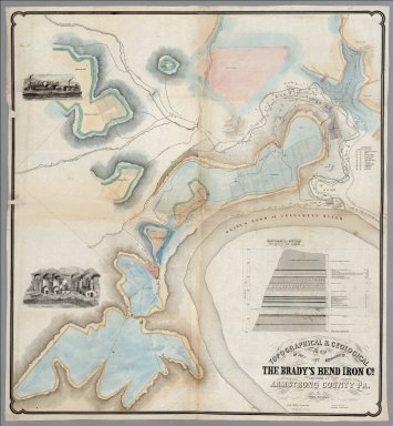
Author
[Franks, Theo., Brady's Bend Iron Co.]
Full Title
Topographical & Geological Map Of The Property Belonging To The Brady's Bend Iron Co. Located In Armstrong County Pa. by Theo. Franks Civil Engineer. From Plan drawn by R. Jennings, Brady's Bend. Wm Schuchman, lith. 3d St, Pittsburgh, Pa. (inset) Geological Section From Notes By Prof. Shepherd.
Publisher
Wm. Schuchman lith.
Author
[Kollner, Augustus, Sunbury and Erie Railroad]
Full Title
Pennsylvania's Great Highway And Its Tributary Lines. Engraved & printed at A. Kollner's Litho Establisht. cor. of Secd. & Dock Sts. Phila.
Publisher
A. Kollner's Litho Establishment
Author
Britton & Rey
Full Title
Map showing the Golden Gate Park, The Avenue And Buena Vista Park. 1903. Lith. Britton & Rey, S.F.
Publisher
Britton & Rey
Author
[Oil and Gas Journal, Petroleum Publishing Company]
Full Title
The Oil and Gas Journal, Producing, Refining, Marketing, Map of Oil Trunk Pipe Lines With Locations of Refineries Shown by Circles. (Copyright 1926 by the Petroleum Publishing Company, Tulsa, Okla.) ... Crude oil is transported through pipe lines at an average rate of four miles an hour.
Publisher
Petroleum Publishing Company
Author
New York Legislature
Full Title
A Map of the State Of New York exhibiting ... the population upon which the apportionment of Senators and Members of the Assembly is based, with tables of apportionment, prepared for the New-York Legislature under the direction of the Secretary of State. Lith. Of E.B. & E.C. Kellogg, Hartford, Connt. (with 9 inset maps).
Publisher
E.B. & E.C. Kellog
Author
Viele, Egbert L.
Full Title
Sanitary & Topographical Map of the City and Island of New York Prepared for the Council of Hygiene and Public Health of the Citizens Association. Under the direction of Egbert L. Viele, Topographical Engineer. Entered ... 1865 by Egbert L. Viele ... New York. Ferd. Mayer & Co. Lithographers, 96 Fulton St. N.Y. (with 1 inset map and 3 profiles).
Publisher
Ferd. Mayer & Co. Lithographers
Author
[Langley, Henry G., Wackenreuder, V.]
Full Title
City And County Of San Francisco. Compiled From Official Surveys And Sectionalized In Accordance With U.S. Surveys. Drawn By V. Wackenreuder, C.E. 1861. Published By Henry G. Langley For the San Francisco Directory. Entered ... 1861 By Henry G. Langley ... California. Britton & Co. Print. (with 3 inset maps of the Farrallon Islands).
Publisher
Henry Langley
Author
Garcia Cubas, Antonio, 1832-1912
Full Title
Carta General de la Republica Mexicana, formada por Antonio Garcia y Cubas
Publisher
H. Iriarte y Ca.
Author
[Thomas Bros., Freese, Harry]
Full Title
Commercial and school map of California ; Compiled, published and copyrighted by Harry Freese ; published and for sale by Thomas Bros. (insets) San Francisco, Oakland and vicinity. Scale 1:335,000 ; Los Angeles and vicinity. Scale 1:335,000 ; Map showing township range survey system in California.
Publisher
Thomas Bros.
Author
[U.S. General Land Office, Ruth, H.]
Full Title
State of Nevada ; compiled from the official records of the General Land office and other sources 1941. (at head of title) United States Department of the Interior Harold L. Ickes, Secretary General Land Office ; Fred W. Johnson, Commissioner. Compiled and drawn by H. Ruth. Relief revised by D.E. Walker. Revised by T.W. Gales.
Publisher
General Land Office
Author
Thompson, Kenneth W.
Full Title
The Americas Served by American Republic Lines ; Grace Line ; Pan American Airways System Pan American-Grace Airways ; United Fruit Company. (by) Kenneth W. Thompson. Printed in U.S.A.
Publisher
No publisher
Author
Olney, Jesse, 1798-1872.
Full Title
Olney's Outline Maps, for Common Schools and General Use. United States ; Ext.2,600,000 Sq. Miles. Population 20 Mil. New York, Pratt, Woodford and Co. Entered according to Act of Congress in ... 1847, by Pratt Woodford ... Southern District of New York.
Publisher
Pratt Woodford
Author
Olney, Jesse, 1798-1872.
Full Title
Olney's Outline Maps, for Common Schools and General Use. Europe ; Extent 3 1/2 M. Sq. Miles. Population 250 M. New York, Pratt, Woodford and Co. Entered according to Act of Congress in ... 1847, by Pratt Woodford ... Southern District of New York.
Publisher
Pratt Woodford
Author
Olney, Jesse, 1798-1872.
Full Title
Olney's Outline Maps, for Common Schools and General Use. Asia ; Extent 16 M. Sq. Miles. Population 600 M. New York, Pratt, Woodford and Co. Entered according to Act of Congress in ... 1847, by Pratt Woodford ... Southern District of New York. (insets) Height of mountains ; and Palestine.
Publisher
Pratt Woodford
Author
Olney, Jesse, 1798-1872.
Full Title
Olney's Outline Maps, for Common Schools and General Use. Africa ; Extent 10 1/2 M. Sq. Miles. Population 60 M. New York, Pratt, Woodford and Co. Entered according to Act of Congress in ... 1847, by Pratt Woodford ... Southern District of New York.
Publisher
Pratt Woodford
Author
Tanner, Henry Schenk
Full Title
A new map of the state of Arkansas, constructed principally from the United States surveys exhibiting the counties, townships & sections by H.S. Tanner. Published by H.S. tanner, Philadelphia. Entered according to Act of Congress in ... 1839, by H.S. Tanner in ... Eastern District of Pennsylvania.
Publisher
H.S. Tanner
Author
Edward Denny & Co.
Full Title
Denny's pocket map of San Benito County, California : compiled from latest official and private data. By Edward Denny & Co. Map publishers, 338 Bush Street, San Francisco. Copyright 1913 by Edward Denny & Co. Revised, January 1st., 1920.
Publisher
Edward Denny & Co.
Author
New Mexico State Tourist Bureau
Full Title
Recreational map of New Mexico : the land of enchantment. Printed ... distributed by the New Mexico State Tourist Bureau a division of the State Highway Department, State Capitol, Santa Fe. Copyright 1946, New Mexico State Tourist Bureau, Santa Fe, New Mexico. Litho. in U.S. (on verso) panel title, portfolio, text, descriptive tourist notes.
Publisher
New Mexico State Tourist Bureau a division of the State Highway Department
Author
Brown, Harold Haven
Full Title
The picture map of the Holy Land. Designed and drawn by Harold Haven Brow. Published by R.R. Bowker Company, 62 West 45th St., New York, Copyright 1928. (insets) Jerusalem and its environs. Jerusalem. Profile view of Palestine showing relative height and position of important localities. Map of Palestine showing heights of land thus: Yellow , 0-500 ft; Purple, 500-1500 ft; 1500-300 ft; Pink, over 3000 ft. Black, below sea level.
Publisher
R.R. Bowker Company
Author
Brown, Harold Haven
Full Title
Picture map of Massachusetts. Designed and drawn by Harold Haven Brown. Published by R.R. Bowker Company, 62 West 45th St., New York, Copyright 1930. (insets) Boston during three centuries ; Battle of Bunker Hill ; Boston & country adjacent ; bunker Hill Monument.
Publisher
R.R. Bowker Company
Author
Rand McNally & Co.
Full Title
Rand McNally & Co.'s sectional map of the Dakota and the Black Hills. Printed expressly for J. Bride & Co.'s Great American 25 Cent package, 767 and 769 Broadway, New York City. A.W. Barber, Del. Rand McNally & Co. Printers, engravers and electrotypers, 79 Madison Street, Chicago. (with 8 insets). (on verso) Rand McNally & Co.'s new railway guide map.
Publisher
Rand McNally & Co.
Author
Rand McNally & Co.
Full Title
Rand McNally & Co.'s new railway guide map. Printed expressly for J. Bride & Co.'s Great American 25 Cent package, 767 and 769 Broadway, New York City. A.W. Barber, Del. Rand McNally & Co. Printers, engravers and electrotypers, 79 Madison Street, Chicago. (with 2 insets). (on verso) Rand McNally & Co.'s sectional map of the Dakota and the Black Hills.
Publisher
Rand McNally & Co.
Author
Berghaus, Henry
Full Title
West Coast of South America. Peru and Bolivia ... Quilca to Cobija. Observations made on Board of H.M.S. Princess Louisa, Royal Prussian Mercantile Navy, 1827, and various Authorities by Henry Berghaus L.L.D. F.R.G.S. Regius Professor, and Principal of the geographical Institute. Potsdam, 1839. Published at the office of geogr. Institute, Potsdam, June 1, 1847. (inset) Plan of the Port of Yquique (Iquique) and principal Mines of Guantajaya; with the roads from the Port.
Publisher
Office of Geographic Institute
|