Browse All

1944 Map III, Italy & South France Separate Map [World War II battlefronts]. Map III, It … |

1944 Map IV. The Western Front Separate Map [World War II battlefronts]. Map IV. The … |

1944 Map V. Southeastern Asia Separate Map [World War II battlefronts]. Map V. Sout … |

1944 Map VI. The Southwest Pacific Separate Map [World War II battlefronts]. Map VI. The … |

1944 Map VII. The North Pacific Separate Map [World War II battlefronts]. Map VII. Th … |

1943 World Island. A Fortune Map. Orthographi … Separate Map World Island. A Fortune Map. Orthographi … |

1942 Pacific Arena. A Fortune Map. Orthograph … Separate Map Pacific Arena. A Fortune Map. Orthograph … |
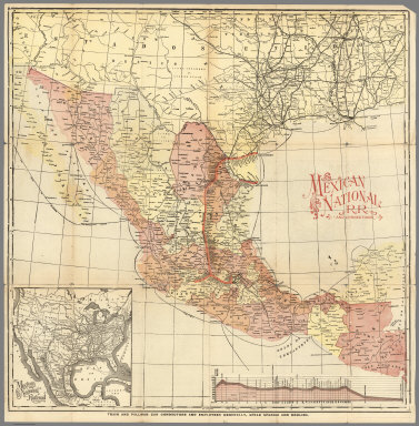
1897 Mexico National R.R. Loredo Route ... Sh … Separate Map Mexico National R.R. and Connections. |

1942 World News of the Week : Monday, Apr. 20 … Separate Map World News of the Week : Monday, Apr. 20 … |

1937 South America in globular perspective. Separate Map South America in globular perspective. ( … |

1934 A Picture Map of Cape Ann and the North … Separate Map A Picture Map of Cape Ann and the North … |

1944 Europe as Viewed from the U.S.S.R. Separate Map Europe as Viewed from the U.S.S.R. Newsm … |

1944 Vicinity of Florence, Italy. Guam, Agigu … Separate Map Newsmap. (War front near Florence, Italy … |

1945 Major Bases Proposed for Postwar U.S. Na … Separate Map Major Bases Proposed for Postwar U.S. Na … |

1943 Target Tokyo. Separate Map Target Tokyo. Newsmap. Monday, October 1 … |

1943 Newsmap. Monday, October 18, 1943. Roads … Separate Map Newsmap. Monday, October 18, 1943. ... V … |

1943 Target Berlin. Separate Map Target Berlin. Newsmap. Monday, October … |

1943 Newsmap. Monday, October 18, 1943. Dnepr … Separate Map Newsmap. Monday, October 25, 1943. ... V … |

1943 Japan from Siberia. Separate Map Japan from Siberia. Newsmap. Monday, May … |

1945 Newsmap. Monday, May 7, 1945. ... Vol. I … Separate Map Newsmap. Monday, May 7, 1945. ... Vol. I … |

1936 Pictorial Map of Kansas. Separate Map (Pictorial Map of Kansas). |

1941 The Hawaiian Islands. Separate Map "The Hawaiian Islands". Colored Cartogra … |

1941 The Hawaiian Islands. Separate Map The Hawaiian Islands. |

1932 Monterey Bay Region. Separate Map A Cartograph of Monterey Bay Region. |
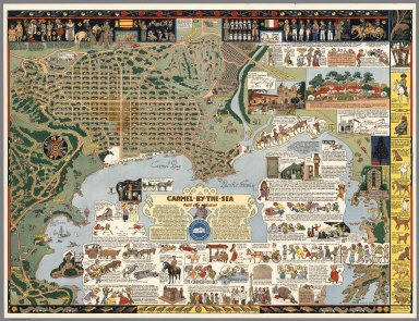
1942 Carmel-by-the-Sea : Past and present Separate Map Carmel-by-the-Sea : Past and present. Ma … |

1938 Color Relief Map of Abyssinia and War Zo … Separate Map Color Relief Map of Abyssinia and War Zo … |

1928 The heart of Cleveland, Ohio. Forest Cit … Separate Map The heart of Cleveland, Ohio. Forest Cit … |

1902 Mexico National R.R. Loredo Route and Co … Separate Map Map of the Mexico National R.R. Loredo R … |

1945 Pictorial Map of the Americas featuring … Separate Map Pictorial Map of the Americas featuring … |

1943 Global Map for Global War and Global Pea … Separate Map Global Map for Global War and Global Pea … |

1925 Covers: Great Northern Recreational Map … Separate Map (Covers to) Great Northern Recreational … |

1925 Great Northern Recreational Map of Glaci … Separate Map Great Northern Recreational Map of Glaci … |

1944 Rand McNally Map of United States Milita … Separate Map Rand McNally Map of United States Milita … |

1948 Hysterical Map of Death Valley National … Separate Map A Hysterical Map of Death Valley Nationa … |

1861 Our Nation's Camp Ground. Separate Map Our Nation's Camp Ground. Published By E … |

1925 A Pictorial Map of Palo Alto and San Fra … Separate Map A Pictorial Map of Palo Alto and San Fra … |

1936 A Hysterical Map of the Yellowstone Park … Separate Map A Hysterical Map of the Yellowstone Park … |

1932 Tenth Olympic Games Los Angeles, Califor … Separate Map The Tenth Olympic Games Los Angeles, Cal … |

1960 A Pictorial Map of Palo Alto and San Fra … Separate Map A Pictorial Map of Palo Alto and San Fra … |

1939 A Pictorial Map of Palo Alto and San Fra … Separate Map A Pictorial Map of Palo Alto and San Fra … |
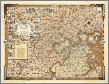
1938 Boston (Massachusetts) and Vicinity. A P … Separate Map Boston (Massachusetts) and Vicinity. A P … |

1939 World Wonders, A Pictorial Map. Separate Map World Wonders, A Pictorial Map. Designed … |

1942 Moore-McCormack Lines Pictorial Map of S … Separate Map Moore-McCormack Lines Pictorial Map of S … |

1945 A pictorial map of North America Separate Map A pictorial map of North America : desig … |

1939 Pictorial Map of the New England States … Separate Map A Pictorial Map of the New England State … |

1935 A Pictorial Map of Germany Separate Map A Pictorial Map of Germany : by Ernest D … |

1948 KLM Royal Dutch Airlines. Separate Map KLM Royal Dutch Airlines. 1919 - 30th Ye … |

1935 Mexico. Views: Azatlan, Sinaloa, and Gua … Separate Map A Map of Mexico. (Views) Azatlan, Sinalo … |

1939 Our (San Francisco) Bay and Bridges. Separate Map This Cartograph Shows a birds-eye view o … |

1955 Picture Chart of Cape Cod, Martha's Viny … Separate Map A Picture Chart of Cape Cod, Martha's Vi … |