Browse All

1862 Map Of The Country Between Monterey, Ten … Separate Map Map Of The Country Between Monterey, Ten … |

1863 Map Of The Siege Of Vicksburg, Miss. Separate Map Map Of The Siege Of Vicksburg, Miss. By … |

1863 Military Map ... of the country adjacent … Separate Map Military Map showing the topographical f … |

1862 Map Of The Field Of Shiloh, Near Pittsbu … Separate Map Map Of The Field Of Shiloh, Near Pittsbu … |

1864 Map illustrating the Siege of Atlanta, G … Separate Map Map illustrating the Siege of Atlanta, G … |

1864 Hughes Military Map Of Richmond & Peters … Separate Map Hughes Military Map Of Richmond & Peters … |

1861 Map of the Atlantic States, Showing Dist … Separate Map Map of the Atlantic States, Showing Dist … |

1885 The Unique Map Of California. Separate Map The Unique Map Of California. Copyrighte … |

1853 Mapa Historico Pintoresca Moderno de al … Separate Map Mapa Historico Pintoresca Moderno de al … |

1853 Plano Pintoresco De La Habana con los nu … Separate Map Plano Pintoresco De La Habana con los nu … |

1862 War Telegram Marking Map. Separate Map War Telegram Marking Map. L. Prang & Co. … |

1863 DeGroot's Map Of Nevada Territory. Separate Map DeGroot's Map Of Nevada Territory Exhibi … |

1830 United States. [Manuscript Map, Separate Map] United States. Maria Symonds. Topsfield … |

1832 Africa. Separate Map Africa Drawn By Amanda M. Chapin. |

1861 Union Military Chart. Separate Map Union Military Chart. Complete Map Of Th … |

1862 Official Plan of The Siege Of Yorktown V … Separate Map Official Plan of The Siege Of Yorktown V … |

1862 White House To Harrisons Landing. Separate Map Campaign Map, Army Of The Potomac. Map N … |

1862 Williamsburg To White House. Separate Map Campaign Map, Army Of The Potomac. Map N … |

1862 Yorktown To Williamsburg. Separate Map Campaign Maps, Army Of The Potomac. Map … |

1936 Territory of Alaska. Separate Map Territory of Alaska. The Alaska Line. Th … |

1890 City Of Seattle And Environs. Separate Map Anderson's New Guide Map Of The City Of … |

1845 Map Exhibiting The ... Lines for the New … Separate Map Map Exhibiting The Experimental and Loca … |

1835 Map of the United States of America. Separate Map Map Of The United States Of America With … |

1853 Map of the State of California. Separate Map Map Of The State Of California. Publishe … |

1847 Map Of The Valley Of Mexico and the Surr … Separate Map Map Of The Valley Of Mexico and the Surr … |

1913 Map Of Long Island, New York. Separate Map Topographical Map Of Long Island, New Yo … |

1857 Texas of the United States of America. Separate Map Texas Of The United States Of America, S … |

1857 United States of America. Separate Map United States of America. |

1820 Composite: United States of Nth. America … Separate Map (Composite of) United States of Nth. Ame … |

1820 Sheet 1: United States of Nth. America. Separate Map (Sheet 1) United States of Nth. America. … |

1820 Sheet 2: United States of Nth. America. Separate Map (Sheet 2) United States of Nth. America. … |

1820 Sheet 3: United States of Nth. America. Separate Map (Sheet 3) United States of Nth. America. … |

1820 Sheet 4: United States of Nth. America. Separate Map (Sheet 4) United States of Nth. America. … |

1820 Sheet 5-6: United States of Nth. America … Separate Map (Sheet 5-6) United States of Nth. Americ … |

1812 Composite: United States of Nth. America … Separate Map (Composite of) United States of Nth. Ame … |

1812 Sheet 1: United States of Nth. America. Separate Map (Sheet 1) United States of Nth. America. … |

1812 Sheet 2: United States of Nth. America. Separate Map (Sheet 2) United States of Nth. America. … |

1812 Sheet 3: United States of Nth. America. Separate Map (Sheet 3) United States of Nth. America. … |

1812 Sheet 4: United States of Nth. America. Separate Map (Sheet 4) United States of Nth. America. … |

1802 Philadelphia. Separate Map To The Citizens Of Philadelphia This New … |

1890 San Francisco. Separate Map Guide Map Of The City Of San Francisco C … |

1804 North America. Separate Map North America, published the 12th of Aug … |

1862 Lloyd's map of the Lower Mississippi Riv … Separate Map Lloyd's map of the Lower Mississippi Riv … |

1839 Map to illustrate the route of Prince Ma … Separate Map Carte itineraire de Prince Maximilian de … |

1865 Military map showing the marches of the … Separate Map Military map showing the marches of the … |

1822 Map Of South Carolina (southeast portion … Separate Map A Map Of South Carolina (southeast porti … |

1822 Map Of South Carolina (southwest portion … Separate Map A Map Of South Carolina (southwest porti … |

1822 Map Of South Carolina (northeast portion … Separate Map A Map Of South Carolina (northeast porti … |

1822 Map Of South Carolina (northwest portion … Separate Map A Map Of South Carolina (northwest porti … |
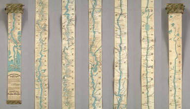
1866 Ribbon Map Of The Father Of Waters. Separate Map Coloney & Fairchild's Patent Ribbon Maps … |