Who What Where WhenREMOVEWHERE
|
Author
Matz, Otto H.
Full Title
Map Of The Country Between Monterey, Tenn. & Corinth, Miss. showing The Lines Of Entrenchments Made & The Routes Followed by The U.S. Forces under the Command of Maj. Genl. Halleck, U.S. Army, In Their Advance Upon Corinth, In May 1862: Surveyed under the direction of Col Geo. Thom, A.D.C. & Chief Of Topl Engrs. Department Of The Mississippi, by Lieuts. Fred. Schraag and C.L. Spangenberg Asst. Topl. Engrs. and drawn by Lieut. Otto H. Matz Asst. Topl. Engr. Lith of J. Bien, 180 Broadway N.Y.
Publisher
J. Bien
Author
Spangenberg, Charles
Full Title
Map Of The Siege Of Vicksburg, Miss. By the U.S. Forces Under The Command Of Maj. Genl. U.S. Grant, U.S. Vls. ... Surveyed and constructed under the direction of Capt. C.B. Comstock ... by Major Otto H. Matz ... Chs. Spangenberg ... Drawn by Chs. Spangenberg ... Engr. on stone by J. Schedler No. 120 Pearl St. N.Y. Head Qrs. Of The Dept. Of The Tenn. Vicksburg Miss. Aug. 20th 1863. C.B. Comstock ...
Publisher
J. Schedler
Author
Weyss, John E.
Full Title
Military Map showing the topographical features of the country adjacent to Harper's Ferry Va. including Maryland, Loudoun, and Bolivar Heights, and portions of South and Short Mountains, with the positions of the Defensive Works, also the Junction of the Potomac & Shenandoah Rivers, and their passage through the Blue Ridge. Surveyed from August 3d to Sept. 30th 1863 Under The Direction Of Capt. N. Michler, Corps of Engrs U.S. Army By Major John E. Weyss, Principal Assistant, Engineer Department, Army Of The Potomac ...
Publisher
Engr. Dept U.S. Army
Author
Matz, Otto H.
Full Title
Map Of The Field Of Shiloh, Near Pittsburgh Landing, Tenn. Shewing The Position of the U.S. Forces under the Command Of Maj. Genl. U.S. Grant U.S. Vol. And Maj. Genl. D.C. Buell U.S. Vol. On The 6th And 7th of April 1862. Surveyed Under The Direction Of Col. Geo Thom. Chief of Topl. Engrs. Drawn by Otto H. Matz, Asst. Topl. Engr. Lith. by Chas. Robyn & Co. cor. Chestnut and 3d St, St. Louis Mo.
Publisher
Chas. Robyn & Co.
Author
Poe, Orlando M.
Full Title
Map illustrating the Siege of Atlanta, Ga. by the U.S. Forces, under Command of Maj. Gen. W.T. Sherman from the passage of Peach Tree Creek, July 19th 1864 to the commencement of the movement upon the Enemy's Lines of communication south of Atlanta, August 26, 1864 ... Reduced and engraved in the Engineers Bureau, War Dept. from an original prepared under the directions of Cap. O.M. Poe, Corps of Engs. and Senr. Engr. on Genl Sherman's Staff. Edw. Molitor, Lith.
Publisher
Edward Molitor, Lith.
Author
Hughes, W.C. Major
Full Title
Hughes Military Map Of Richmond & Petersburgh, Va. Showing the Rebel Fortifications drawn on the ground for the War Department by Major W.C. Hughes of Michigan. Published by Philip & Solomons, Washn. D.C. Print by J.F. Gedney, Washn. Willenbucher, Lith. Respectfully dedicated to the Army of the Potomac.
Publisher
Philip & Solomons
Author
Prang, L. & Co.
Full Title
Map of the Atlantic States, Showing Distances From Washington (In BeeLine) By 50 Mile Circles. (The Traveling Distance is about 1/6 to 1/3 more than the BeeLine.) (with) Map of the Battle Ground (with) Map of Norfolk Harbor, Fort Monroe, and Vicinity. (with two insets) Position of Forces at Bull Run and Fortress Monroe. Published By L. Prang & Co. - No. 84 Merchants Row, Boston, Mass. Entered ... 1861 by L. Prang & Co. ... Massachusetts.
Publisher
L. Prang & Co.
Author
Johnstone, E. McD.
Full Title
The Unique Map Of California. Copyrighted. E. McD. Johnstone. Dickman-Jones Co. Lith. S.F. (with 3 inset maps, 1 profile).
Publisher
Dickman Jones Co. Lith.
Author
May, B. y Ca.
Full Title
Mapa Historico Pintoresca Moderno de al Isla De Cuba. (with) 16 inset views of Cuba.
Publisher
B. May y Ca.
Author
May, B. y Ca.
Full Title
Plano Pintoresco De La Habana con los numeros de las casas B. May y Ca. 1853. (with) Inset map Puerto y Cereanias De La Habana. (with) 14 views of Havana & prominent buildings.
Publisher
B. May y Ca.
Author
Prang, L. & Co.
Full Title
War Telegram Marking Map. L. Prang & Co. Print Publishers, 159, Washington St. Boston ... Entered ... 1862 by L. Prang & Co. ... Massachusetts.
Publisher
L. Prang
Author
[DeGroot, Henry, Holt, Warren]
Full Title
DeGroot's Map Of Nevada Territory Exhibiting A Portion Of Southern Oregon & Eastern California With County Boundaries, Mining Districts, Railroad Routes, Wagon Roads, Table Of Distances, &c. &c. Published By Warren Holt, 305 Montgomery St. San Francisco, Cal. 1863. Entered ... 1862 by Warren Holt ... California.
Publisher
Warren Holt
Author
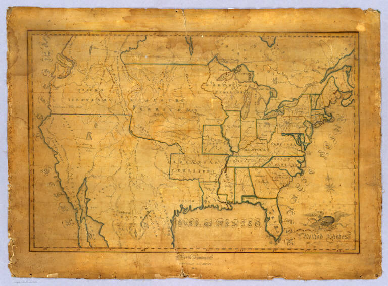
Symonds, Maria
Full Title
United States. Maria Symonds. Topsfield Academy. 1830.
Publisher
Manuscript
Author
Chapin, Amanda
Full Title
Africa Drawn By Amanda M. Chapin.
Publisher
Manuscript
Author
Magnus, Charles
Full Title
Union Military Chart. Complete Map Of The Rail Roads And Water Courses In The United States & Canada. Charles Magnus & Co. ... Liverpool, New York Office No. 12 Frankfort St. ... Entered ... 1859 by Charles Magnus & Co. ... New York. (with) Military Map Of Maryland & Virginia. (with) Map Of Northern Military Movements: Between New York & St. Louis. Published by Chs. Magnus ... Entered ... 1861 by Charles Magnus ... New York. (with two small untitled maps: Pensacola Bay and United States).
Publisher
Charles Magnus
Author
Abbot, Henry L.
Full Title
Official Plan of The Siege Of Yorktown Va. Conducted by the Army of the Potomac under the command of Maj. Gen. George B. McClellan U.S.A. April 5th to May 3rd 1862. Prepared under the direction of Brig. Gen J.G. Barnard Chief Engr. by Lieut. Henry L. Abbot Top. Engrs. A.D.C. ... Lith. by J.F. Gedney, Washn. Chas. G. Krebs, Engr.
Publisher
J.F. Gedney
Author
Abbot, Henry L.
Full Title
Campaign Map, Army Of The Potomac. Map No. 3 White House To Harrisons Landing. Prepared By Command Of Maj. Gen. George B. McClellan, U.S.A. Commanding Army Of The Potomac Brig. Gen. A.A. Humphreys ... Compilation under the Direction of Brig. Gen. A.A. Humphreys, By Capt. H.L. Abbot, Top. Engrs. Engraved by W.H. Dougal.
Publisher
U.S.
Author
Abbot, Henry L.
Full Title
Campaign Map, Army Of The Potomac. Map No. 2 Williamsburg To White House. Prepared By Command Of Maj. Gen. George B. McClellan, U.S.A. Commanding Army Of The Potomac Brig. Gen. A.A. Humphreys ... Compilation under the Direction of Brig. Gen. A.A. Humphreys, By Capt. H.L. Abbot, Top. Engrs. Engraved by W.H. Dougal.
Publisher
U.S.
Author
Abbot, Henry L.
Full Title
Campaign Maps, Army Of The Potomac. Map No. 1 Yorktown To Williamsburg. Prepared By Command Of Maj. Gen. George B. McClellan U.S.A. Commanding Army Of The Potomac Brig. Gen. A.A. Humphreys ... Compilation under the Direction of Brig. Gen. A.A. Humphreys, By Capt. H.L. Abbot, Top. Engrs. Engraved by W.H. Dougal.
Publisher
U.S.
Author
Alaska Steamship Company
Full Title
Territory of Alaska. The Alaska Line. The All-American Route, Alaska Steamship Company, Serving All of Alaska. Copyright 1936, Frank McCaffrey, Seattle. Printed in U.S.A. (with two inset maps)
Publisher
Frank McCaffrey
Author
Anderson, O.P. and Co.
Full Title
Anderson's New Guide Map Of The City Of Seattle And Environs, Washington. Compiled From Latest Official Records By O.P. Anderson And Co. Engineers and Draughtsmen. July, 1890. L.H. Everts, Phila. Pa. Prepared For Eshelman, Llewellyn & Co. Investment Brokers, Seattle, Washington. Entered ... 1890, by O.P. Anderson & Co. ... Washington, D.C. (untitled inset of the Seattle vicinity).
Publisher
L.H. Everts
Author
Anderson, P.
Full Title
Map Exhibiting The Experimental and Located Lines for the New-York and New-Haven Rail-Road ... Projected and Drawn by P. Anderson Civil Engr. Scale 1 to 40,000. Febr. 1845. Snyder & Black Lithogrs. 87 Fulton St. New-York.
Publisher
Snyder & Black Lithogrs.
Author
[Barber, B.B., Willard, A.]
Full Title
Map Of The United States Of America With Its Territories & Districts. Including also a part of Upper & Lower Canada And Mexico. Published By B.B. Barber & A. Willard, Hartford, 1835.
Publisher
Barber and Willard
Author
Trask, John B.
Full Title
Map Of The State Of California. Published by Britton & Rey Lithographers, Cor. of Commercial & Montgomery Sts. San Francisco. Drawn & Compiled from the most recent Surveys by J.B. Trask. Entered ... 1853 by Britton & Rey ... California.
Publisher
Britton & Rey
Author
[Bruff, J. Goldsborough, Disturnell, John]
Full Title
Map Of The Valley Of Mexico and the Surrounding Mountains. New York, Published by J.Disturnell, No. 102 Broadway, 1847. Miller's Lith. 102 Broadway, N.Y. Entered ... 1847, by John Disturnell ... New York. (inset) Map of the Route between Vera Cruz, Alvarado & Puebla. (inset) Profile Of The Route Between Mexico And Vera Cruz.
Publisher
J. Disturnell
Author
U.S. Geological Survey
Full Title
Topographical Map Of Long Island, New York. Engraved From U.S. Geological Survey Topographic Sheets ... 1913. Julius Bien Co. Lith. N.Y. U.S. Geological Survey, George Otis Smith, Director. Professional Paper 82 Plate II.
Publisher
Julius Bien & Co.
Author
Galveston, Houston, & Henderson Railroad
Full Title
Texas Of The United States Of America, Shewing The Galveston, Houston, & Henderson Rail Road. King, Lith. 63 Queen St. New Cannon St. London.
Publisher
King, Lith.
Author
Galveston, Houston, & Henderson Railroad
Full Title
United States of America.
Publisher
King, Lith.
Author
Tardieu, P.F.
Full Title
(Composite of) United States of Nth. America. Carte des Etats-Unis de L'Amerique Septentrionale Copiee et Gravee sur celle d'Arrowsmith Corrigee et considerablem ent augmentee d'Apres les renseignemens les plus authentiques Par P.F. Tardieu, Graveur, Editeur-proprietaire. Place de l'Estrapade No. 34. 'A Paris 1820. a Paris, Ches: Tardieu ... Dezauche, Ingenieur Geographe, Rue des Noyers. Chles. Picquet, Geographe - Graveur Quai de la Monnaie No. 17. J. Goujon Marchand de Cartes Geographiques, Rue du Bac No. 6. Ecrit par J.J. Pachoux. (with 1 inset map).
Publisher
P.F. Tardieu
Author
Tardieu, P.F.
Full Title
(Sheet 1) United States of Nth. America. Carte des Etats-Unis de L'Amerique Septentrionale Copiee et Gravee sur celle d'Arrowsmith Corrigee et considerablem ent augmentee d'Apres les renseignemens les plus authentiques Par P.F. Tardieu, Graveur, Editeur-proprietaire. Place de l'Estrapade No. 34. 'A Paris 1820. a Paris, Ches: Tardieu ... Dezauche, Ingenieur Geographe, Rue des Noyers. Chles. Picquet, Geographe - Graveur Quai de la Monnaie No. 17. J. Goujon Marchand de Cartes Geographiques, Rue du Bac No. 6. Ecrit par J.J. Pachoux. (with 1 inset map).
Publisher
P.F. Tardieu
Author
Tardieu, P.F.
Full Title
(Sheet 2) United States of Nth. America. Carte des Etats-Unis de L'Amerique Septentrionale Copiee et Gravee sur celle d'Arrowsmith Corrigee et considerablem ent augmentee d'Apres les renseignemens les plus authentiques Par P.F. Tardieu, Graveur, Editeur-proprietaire. Place de l'Estrapade No. 34. 'A Paris 1820. a Paris, Ches: Tardieu ... Dezauche, Ingenieur Geographe, Rue des Noyers. Chles. Picquet, Geographe - Graveur Quai de la Monnaie No. 17. J. Goujon Marchand de Cartes Geographiques, Rue du Bac No. 6. Ecrit par J.J. Pachoux. (with 1 inset map).
Publisher
P.F. Tardieu
Author
Tardieu, P.F.
Full Title
(Sheet 3) United States of Nth. America. Carte des Etats-Unis de L'Amerique Septentrionale Copiee et Gravee sur celle d'Arrowsmith Corrigee et considerablem ent augmentee d'Apres les renseignemens les plus authentiques Par P.F. Tardieu, Graveur, Editeur-proprietaire. Place de l'Estrapade No. 34. 'A Paris 1820. a Paris, Ches: Tardieu ... Dezauche, Ingenieur Geographe, Rue des Noyers. Chles. Picquet, Geographe - Graveur Quai de la Monnaie No. 17. J. Goujon Marchand de Cartes Geographiques, Rue du Bac No. 6. Ecrit par J.J. Pachoux. (with 1 inset map).
Publisher
P.F. Tardieu
Author
Tardieu, P.F.
Full Title
(Sheet 4) United States of Nth. America. Carte des Etats-Unis de L'Amerique Septentrionale Copiee et Gravee sur celle d'Arrowsmith Corrigee et considerablem ent augmentee d'Apres les renseignemens les plus authentiques Par P.F. Tardieu, Graveur, Editeur-proprietaire. Place de l'Estrapade No. 34. 'A Paris 1820. a Paris, Ches: Tardieu ... Dezauche, Ingenieur Geographe, Rue des Noyers. Chles. Picquet, Geographe - Graveur Quai de la Monnaie No. 17. J. Goujon Marchand de Cartes Geographiques, Rue du Bac No. 6. Ecrit par J.J. Pachoux. (with 1 inset map).
Publisher
P.F. Tardieu
Author
Tardieu, P.F.
Full Title
(Sheet 5-6) United States of Nth. America. Carte des Etats-Unis de L'Amerique Septentrionale Copiee et Gravee sur celle d'Arrowsmith Corrigee et considerablem ent augmentee d'Apres les renseignemens les plus authentiques Par P.F. Tardieu, Graveur, Editeur-proprietaire. Place de l'Estrapade No. 34. 'A Paris 1820. a Paris, Ches: Tardieu ... Dezauche, Ingenieur Geographe, Rue des Noyers. Chles. Picquet, Geographe - Graveur Quai de la Monnaie No. 17. J. Goujon Marchand de Cartes Geographiques, Rue du Bac No. 6. Ecrit par J.J. Pachoux. (with 1 inset map).
Publisher
P.F. Tardieu
Author
Tardieu, P.F.
Full Title
(Composite of) United States of Nth. America. Carte des Etats-Unis de L'Amerique Septentrionale Copiee et Gravee sur celle d'Arrowsmith Corrigee et considerablem ent augmentee d'Apres les renseignemens les plus authentiques Par P.F. Tardieu, Graveur, Editeur-proprietaire. Place de l'Estrapade No. 1. 'A Paris 1812. a Paris, Ches: Tardieu ... Dezauche, Ingenieur Geographe, Rue des Noyers. Chles. Picquet, Geographe - Graveur Quai de la Monnaie No. 17. Treuttel et Wurtz, Libraire Rue de Lille No. 17 ... J. Goujon Marchand de Cartes Geographiques, Rue du Bac No. 6. A Bordeaux, chez Augn. Filliatre et Neveu... (with 1 inset map).
Publisher
P.F. Tardieu
Author
Tardieu, P.F.
Full Title
(Sheet 1) United States of Nth. America. Carte des Etats-Unis de L'Amerique Septentrionale Copiee et Gravee sur celle d'Arrowsmith Corrigee et considerablem ent augmentee d'Apres les renseignemens les plus authentiques Par P.F. Tardieu, Graveur, Editeur-proprietaire. Place de l'Estrapade No. 1. 'A Paris 1812. a Paris, Ches: Tardieu ... Dezauche, Ingenieur Geographe, Rue des Noyers. Chles. Picquet, Geographe - Graveur Quai de la Monnaie No. 17. Treuttel et Wurtz, Libraire Rue de Lille No. 17 ... J. Goujon Marchand de Cartes Geographiques, Rue du Bac No. 6. A Bordeaux, chez Augn. Filliatre et Neveu... (with 1 inset map).
Publisher
P.F. Tardieu
Author
Tardieu, P.F.
Full Title
(Sheet 2) United States of Nth. America. Carte des Etats-Unis de L'Amerique Septentrionale Copiee et Gravee sur celle d'Arrowsmith Corrigee et considerablem ent augmentee d'Apres les renseignemens les plus authentiques Par P.F. Tardieu, Graveur, Editeur-proprietaire. Place de l'Estrapade No. 1. 'A Paris 1812. a Paris, Ches: Tardieu ... Dezauche, Ingenieur Geographe, Rue des Noyers. Chles. Picquet, Geographe - Graveur Quai de la Monnaie No. 17. Treuttel et Wurtz, Libraire Rue de Lille No. 17 ... J. Goujon Marchand de Cartes Geographiques, Rue du Bac No. 6. A Bordeaux, chez Augn. Filliatre et Neveu... (with 1 inset map).
Publisher
P.F. Tardieu
Author
Tardieu, P.F.
Full Title
(Sheet 3) United States of Nth. America. Carte des Etats-Unis de L'Amerique Septentrionale Copiee et Gravee sur celle d'Arrowsmith Corrigee et considerablem ent augmentee d'Apres les renseignemens les plus authentiques Par P.F. Tardieu, Graveur, Editeur-proprietaire. Place de l'Estrapade No. 1. 'A Paris 1812. a Paris, Ches: Tardieu ... Dezauche, Ingenieur Geographe, Rue des Noyers. Chles. Picquet, Geographe - Graveur Quai de la Monnaie No. 17. Treuttel et Wurtz, Libraire Rue de Lille No. 17 ... J. Goujon Marchand de Cartes Geographiques, Rue du Bac No. 6. A Bordeaux, chez Augn. Filliatre et Neveu... (with 1 inset map).
Publisher
P.F. Tardieu
Author
Tardieu, P.F.
Full Title
(Sheet 4) United States of Nth. America. Carte des Etats-Unis de L'Amerique Septentrionale Copiee et Gravee sur celle d'Arrowsmith Corrigee et considerablem ent augmentee d'Apres les renseignemens les plus authentiques Par P.F. Tardieu, Graveur, Editeur-proprietaire. Place de l'Estrapade No. 1. 'A Paris 1812. a Paris, Ches: Tardieu ... Dezauche, Ingenieur Geographe, Rue des Noyers. Chles. Picquet, Geographe - Graveur Quai de la Monnaie No. 17. Treuttel et Wurtz, Libraire Rue de Lille No. 17 ... J. Goujon Marchand de Cartes Geographiques, Rue du Bac No. 6. A Bordeaux, chez Augn. Filliatre et Neveu... (with 1 inset map).
Publisher
P.F. Tardieu
Author
Varle, Charles P.
Full Title
To The Citizens Of Philadelphia This New Plan Of The City And Its Environs Is respectfully dedicated By the Editor. 1802. P.C. Varle Geographer & Enginr. Del.
Publisher
Charles P. Varle
Author
Langley, Henry G.
Full Title
Guide Map Of The City Of San Francisco Compiled From The Official Surveys & Engraved Expressly For Langley's San Francisco Directory 1890. Copyright By Geo. B. Wilbur Receiver Of Painter & Co. 1890. McAfee, Baldwin & Hammond. Real Estate Agents And Auctioneers, 10 Montgomery Street, San Francisco. Lots For Sale In All Parts Of The City ...
Publisher
Henry G. Langley
Author
Wilkinson, Robert
Full Title
North America, published the 12th of August 1804. By R. Wilkinson, No.58, Cornhill, London. E. Bourne Sculp.
Publisher
Robert Wilkinson
Author
[Bowen, Bart, Bowen, William, Lloyd, J. T.]
Full Title
Lloyd's map of the Lower Mississippi River from St. Louis to the Gulf of Mexico. Compiled from government surveys in the Topographical Bureau, Washington, D.C. Revised and corrected to the present time by Captains Bart and William Bowen, pilots of twenty years' experience on that River. Exhibiting the sugar and cotton plantations, cities, towns, landings, sand bars, islands, bluffs, bayous, cut-offs, the steamboat channel, mileage, fortifications, railroads. &c. along the River. J.T. Lloyd, Publisher. 164 Broadway, New York 1862. Entered ... 1862, by J.T. Lloyd ... New York.
Publisher
J.T. Lloyd
Author
[Bodmer, Karl, Maximilian of Wied, Thorn, William]
Full Title
Carte itineraire de Prince Maximilian de Wied dans l'interieur de l'Amerique Septentrionale de Boston a Missouri superieur &c. en 1832, 33 et 34. Reise Charte des Prinzen Maximilian zu Wied ... Map to illustrate the route of Prince Maximilian of Wied in the interior of North America from Boston to the Upper Missouri &c. in 1832, 33, & 34 ... (Printed from the original plate in 1993). (with) Great Falls of the Missouri. (with) Itaska Lake or Lac Labiche: the source of the, Der Ursprung des, Mississippi.
Publisher
Editions Alecto (Bodmer) Limited
Author
[Jenney, W. L. B., Kossak, William, Muller, John B., United States. Army. Military Division of the Mississippi]
Full Title
Military map showing the marches of the United States Forces under the command of Maj. Genl. W.T. Sherman, U.S.A. During the years 1863, 1864, 1865 ... Drawn by Capt. William Kossak ... and John B. Muller, draughtsman. St. Louis, Mo., 1865. Printed by Joseph F. Gedney. Engraved at Head Qrs., Corps of Engineers, U.S.A. by H.C. Evans & F. Courtenay.
Publisher
Joseph F. Gedney
Author
[Tanner, Henry S., Wilson, John]
Full Title
A Map Of South Carolina (southeast portion), Constructed and Drawn from the District Surveys, ordered by the Legislature: by John Wilson, late Civil & Military Engineer of So: Cara. The Astronomical Observations by Professor Geo: Blackburn & I.M. Elford. Engraved by H.S. Tanner Philadelphia. Entered according to Act of Congress, the 10th day of April 1822, by John Wilson, Agent of the Board of Public Works of the State of South Carolina.
Publisher
H.S. Tanner
Author
[Tanner, Henry S., Wilson, John]
Full Title
A Map Of South Carolina (southwest portion), Constructed and Drawn from the District Surveys, ordered by the Legislature: by John Wilson, late Civil & Military Engineer of So: Cara. The Astronomical Observations by Professor Geo: Blackburn & I.M. Elford. Engraved by H.S. Tanner Philadelphia. Entered according to Act of Congress, the 10th day of April 1822, by John Wilson, Agent of the Board of Public Works of the State of South Carolina.
Publisher
H.S. Tanner
Author
[Tanner, Henry S., Wilson, John]
Full Title
A Map Of South Carolina (northeast portion), Constructed and Drawn from the District Surveys, ordered by the Legislature: by John Wilson, late Civil & Military Engineer of So: Cara. The Astronomical Observations by Professor Geo: Blackburn & I.M. Elford. Engraved by H.S. Tanner Philadelphia. Entered according to Act of Congress, the 10th day of April 1822, by John Wilson, Agent of the Board of Public Works of the State of South Carolina.
Publisher
H.S. Tanner
Author
[Tanner, Henry S., Wilson, John]
Full Title
A Map Of South Carolina (northwest portion), Constructed and Drawn from the District Surveys, ordered by the Legislature: by John Wilson, late Civil & Military Engineer of So: Cara. The Astronomical Observations by Professor Geo: Blackburn & I.M. Elford. Engraved by H.S. Tanner Philadelphia. Entered according to Act of Congress, the 10th day of April 1822, by John Wilson, Agent of the Board of Public Works of the State of South Carolina.
Publisher
H.S. Tanner
Author
Coloney, Fairchild & Co.
Full Title
Coloney & Fairchild's Patent Ribbon Maps ... Ribbon Map Of The Father Of Waters. Geographical and Scenic Maps upon this plan of all the rivers, rail road routes, stage and coast lines in the country are in preparation.
Publisher
Gast, Moeller & Co. Lith.
|