Browse All

1864 Railroad Map Of Illinois Pocket Map Railroad Map Of Illinois. One Million Ac … |

1875 Map of Los Angeles City Oil Field Mining Atlas Map of Los Angeles City Oil Field, Los A … |

1919 Text Page: Map of Pacific Grove Properti … Separate Map (Text Page to) Map of Pacific Grove Prop … |

1919 Text Page: Map of Pacific Grove Properti … Separate Map (Text Page to) Map of Pacific Grove Prop … |

1859 Official Map Of The City Of San Francisc … Separate Map Official Map Of The City Of San Francisc … |

1888 Park Place, Formerly Known As Laundry Fa … Real Estate Relative Position of Park Place, Laundry … |

1888 Park Place, Formerly Known As Laundry Fa … Real Estate Map showing A Portion Of Park Place, For … |

1887 Roberts and Wolfskill Tract Real Estate Roberts & Wolfskill Tract. The Roberts A … |

1887 Roberts and Wolfskill Tract Real Estate (Untitled map of) Roberts & Wolfskill Tr … |

1831 Plan of the City Of New York Pocket Map Plan of the City Of New York For The Use … |

1854 Map of the State of New York Pocket Map Map of the State of New York. Published … |

1927 Pacific Electric Railway In Southern Cal … Separate Map Lines Of The Pacific Electric Railway In … |

1863 Gettysburg Battle-Field View Gettysburg Battle-Field. Published By Jn … |

1897 Text Page: Guide Map Of The City of San … Separate Map (Text Page to) Guide Map Of The City of … |

1835 States Of Ohio Indiana and Illinois And … Pocket Map The States Of Ohio Indiana & Illinois An … |

1964 Official Road Map Florida The Sunshine S … State Atlas 1964 Official Road Map Florida The Sunsh … |

1964 Verso: Official Road Map Florida The Sun … State Atlas (Verso of) 1964 Official Road Map Florid … |

1964 Inside rear cover: folded Road Map Flori … State Atlas Inside rear cover: folded Road Map Flori … |

1887 View, Pleasant Valley Tract. Separate Map View of Pleasant Valley Tract and City o … |

1874 Verso: Railway Map Of The United States … Separate Map (Verso to) Chisholm's Railway Map Of The … |

1874 Composite: Sheets 1-4, Campaign Maps Neb … Separate Map (Composite of) Sheets 1,2,3,4 Campaign M … |

1890 (Advertisement with) Guide Map Of The Ci … Separate Map (Advertisement with) Guide Map Of The Ci … |

1901 Map of California. Separate Map Map of California with a brief descripti … |

1901 Cover: Map of California. Separate Map (Covers to:) Map of California with a br … |

1862 Title Page: Map of Part of Henrico Count … Separate Map (Title Page to) Part of Henrico County V … |

1889 Text: Map Of Massachusetts. Rhode Island … Separate Map (Text to) Mast, Crowell & Kirkpatrick, P … |

1885 Text: Domestic And Foreign Missions Of T … Separate Map (Text to) One Million For Missions ... J … |

1870 A Portion of the Sierra Nevada adjacent … Guide Book Map of a Portion of the Sierra Nevada ad … |

1915 Covers: Bird's Eye View of the Panama Ca … Separate Map (Covers to) Bird's Eye View of the Panam … |

1915 Text: Panama Canal Photographs and Descr … Separate Map (Text Page) (Panama Canal Photographs an … |

1807 Composite: A Map of Lower Egypt from Var … Separate Map (Composite map of) A Map of Lower Egypt … |

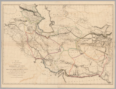
1815 Composite: A Sketch of the Countries bet … Separate Map (Composite map of) A Sketch of the Count … |
1813 Composite: Map of the Countries lying be … Separate Map (Composite Map of) Map of the Countries … |

1804 Composite: A Map of the Environs of Cons … Separate Map (Composite Map of) A Map of the Environs … |

1818 Composite: Map of the Island of Japan, K … Separate Map (Composite Map of) Map of the Island of … |

1834 Pennsylvania Guide Book Pennsylvania. (engraved by) J.H. Young S … |

1866 Composite: Sheets No. 1-7. Photo-Lithogr … Separate Map (Composite of) Sheets No. 1-7. Photo-Lit … |

1883 Historical County, Railroad, Distance An … Separate Map Murray's Matchless Historical County, Ra … |

1883 Illustrated Reference Map Of The World Separate Map The Illustrated Reference Map Of The Wor … |

1863 Map of the Lower Mississippi River From … Separate Map Lloyd's Map of the Lower Mississippi Riv … |

1864 New Map of the United States The Canadas … Separate Map Lloyd's New Map of the United States, Th … |

1845 Covers: State Of New York Separate Map (Covers to) A Map of the State Of New Yo … |

1946 Covers: Recreational map of New Mexico l … Separate Map (Covers to) Recreational map of New Mexi … |

1946 Text Page: Recreational map of New Mexic … Separate Map (Text Page to) Recreational map of New M … |

1951 Historical Trails Through New Mexico, Th … Pictorial Map Historical trails through New Mexico : t … |

1977 The Mystery Map of Assinine Atoll Pictorial Map The Mystery Map of Assinine Atoll. (c)op … |

1926 Bootlegger's Map of the United States Pictorial Map Bootlegger's Map of the United States "H … |

1848 Title Page: Senate Reports 2d S. 30th C. Separate Map (Title Page to) Reports of Committees, P … |

1848 Text Page: Report: In Senate of the Unit … Separate Map (Text Page to) Report: In Senate of the … |

1848 Text Page: (Continues) Report: In Senate … Separate Map (Text Page to) Report: In Senate of the … |