Who What Where WhenREMOVEWHERE
|
Author
Bartholomew, J. G.
Full Title
Africa - Central Commercial Chart. (Base Map includes Vegetation).
Publisher
George Newnes, Limited
Author
Bartholomew, J. G.
Full Title
North Atlantic Chart.
Publisher
George Newnes, Limited
Author
Bartholomew, J. G.
Full Title
North America - General Commercial Chart. (Base Map includes Vegetation).
Publisher
George Newnes, Limited
Author
Bartholomew, J. G.
Full Title
United States. (Base Map includes Vegetation).
Publisher
George Newnes, Limited
Author
Bartholomew, J. G.
Full Title
South America - Central Commercial Chart. (Base Map includes Vegetation).
Publisher
George Newnes, Limited
Author
Bartholomew, J. G.
Full Title
Australia - General Commercial Chart.
Publisher
George Newnes, Limited
Author
Peoples Line
Full Title
Peoples Line New Jersey Steamboat Co. between Albany and New York. Magnificent steamers Drew, and Dean Richmond ... Rand Avery Supply Co., Boston. (with map) Map showing the principal connections of the Peoples Line of Steamers. Rand, Avery & Co., Eng's. (1885)
Publisher
Rand Avery Supply Co.
Author
Peoples Line
Full Title
(Text Page to) Peoples Line New Jersey Steamboat Co. between Albany and New York. Magnificent steamers Drew, and Dean Richmond ... Rand Avery Supply Co., Boston.
Publisher
Rand Avery Supply Co.
Author
Northern Steamship Company
Full Title
In all the World no trip like this Northern Steamship Co. east and west via the Great Lakes. (inset) St. Mary's River. (inset) Lake St. Clair, Detroit and St. Clair Rivers.
Publisher
Poole Bros.
Author
Northern Steamship Company
Full Title
(Covers to) Northern Steamship Co. Northland. Northwest ...
Publisher
Poole Bros.
Author
Central Vermont Railroad Company
Full Title
Central Vermont Railroad excursion routes. Engraved in relief by Photo-Electrotype Co., 171 Devonshire St., Boston. (inset) Railway & steam ship lines connecting with and in the provinces of Nova Scotia, New Brunswick & Prince Edward Id. (1879)
Publisher
Frank Wood
Author
Chicago, Burlington & Quincy Railroad Company
Full Title
Map of the Burlington Route and connections. Poole Bros. Chicago. 5-20-'07 ... (inset map) Direct routes to the Orient. Great Northern Steamship Co. and Chicago, Burlington & Quincy Railway Company.
Publisher
Poole Bros.
Author
Bevan, G. Phillips
Full Title
England and Wales to Illustrate the Marine Commercial Position of the Country by G. Phillips Bevan, F.S.S., F.G.S., 1881.
Publisher
W. &. A.K. Johnston
Author
Bevan, G. Phillips
Full Title
Scotland to Illustrate the Marine Commercial Position of the Country by G. Phillips Bevan, F.S.S., F.G.S., 1881.
Publisher
W. &. A.K. Johnston
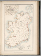
Author
Bevan, G. Phillips
Full Title
Ireland to Illustrate the Marine Commercial Position of the Country by G. Phillips Bevan, F.S.S., F.G.S., 1881.
Publisher
W. &. A.K. Johnston
Author
Stieler, Adolf
Full Title
Deutschland Und Benachbarte Lander. Zur Ubersicht Der Eisenbahnen Und Dampfschiffahrten. Bearbeitet von C. Vogel. Abgeschlossen im August 1871. Gestochen von H. Eberhardt. Gotha: Justus Perthes. 1872.
Publisher
Justus Perthes
Author
[De Pue & Company, Galloway, W. T. (William T.)]
Full Title
Dairy and stock farm of S.A. Bentley, Sacramento River, Yolo Co., Cal. (with) Residence of Jacob Guysi, South Putah, Yolo, Yolo Co., Cal. (with) Residence and stock ranch of Charles Clay, Yolo Co., Cal. De Pue & Co. Pub., S.F. Lith. W.T. Galloway, S.F. (1879)
Publisher
De Pue & Company
Author
Bibliographische Institut
Full Title
Map of North America. Karte von Nordamerika. HAPAG. Bibliographische Institut AG. Leipzig. Printed in Germany.
Publisher
Bibliographische Institut AG,
Author
Hammond, C.S.
Full Title
Arctic Ocean. 9471. Antarctica. Pacific Ocean. 2426.
Publisher
Garden City Publishing Company, Inc.
Author
[Collins, Greenvile, Moll, Herman, d. 1732]
Full Title
A chart of part of ye sea coast of England, Holland & Flanders &c. Shewing the sands, banks, depth of water, bearing, and the course of the principal tracts from the River Thames, and Harwich, &c. to ye Texel, Helevoet Sluys, Ostend, Calais, and their distances in English miles, with remarks. By Herman Moll Geographer, according to Capt. G. Collins. (Printed and sold by T. Bowles next ye Chapter House in St. Pauls Churchyard, & I. Bowles at ye Black Horse in Cornhill. 1736?)
Publisher
Thos. Bowles and John Bowles
Author
Mitchell, Samuel Augustus Jr.
Full Title
Railroad map of the United States, showing the through lines of communication from the Atlantic to the Pacific, together with the various steamship lines along the seaboard. Copyright by Wm. M. Bradley & Bro. 1884.
Publisher
Wm. M. Bradley & Bro.
Full Title
Railroad map of the United States, showing the through lines of communication from the Atlantic to the Pacific, together with the various steamship lines along the seaboard. W. H. Gamble, Sc. Copyright 1886 by Wm. M. Bradley & Bro.
Publisher
Wm. M. Bradley & Bro.
Author
Rand McNally and Company
Full Title
Miles of railroads in the United States, 1830-1893. Miles of railroads, by states, January 1st, 1894. Freight traffic on the Great Lakes, by ports, 1889. Rand, McNally & Co., Engravers, Chicago. (1897)
Publisher
Rand McNally
Author
Rand McNally and Company
Full Title
The foreign commerce of the United States, divided by means of transportation employed in the carrying trade ... 1890 to ... 1891. Tonnage of American and foreign vessels entered at the seaports of the United States ... 1791 to 1815 and 1821 to 1891. The national debt of the United States ... between 1783 and 1890. The State, county, municipality and school district debts in the United States, combined, by states and territories, 1890. Rand, McNally & Co., Engravers, Chicago. (1897)
Publisher
Rand McNally
|