Who What Where WhenREMOVEWHAT
WHEREShow MoreWHO
WHEN |
Author
Burr, David H., 1803-1875
Full Title
Map of the counties of Ontario & Yates. By David H. Burr. Published by the Surveyor General, pursuant to an Act of the Legislature. Entered according to an Act of Congress Jany. 5th. 1829 by David H. Burr of the State of New York. Engd. by Rawdon, Clark & Co., Albany & Rawdon, Wright & Co., N.Y.
Publisher
D.H. Burr
Author
Burr, David H., 1803-1875
Full Title
Map of the County of Wayne. By David H. Burr. Published by the Surveyor General, pursuant to an Act of the Legislature. Entered according to an Act of Congress Jany. 5th. 1829 by David H. Burr of the State of New York. Engd. by Rawdon, Clark & Co., Albany & Rawdon, Wright & Co., N.Y.
Publisher
D.H. Burr
Author
Burr, David H., 1803-1875
Full Title
Map of the County of Livingston. By David H. Burr. Published by the Surveyor General, pursuant to an Act of the Legislature. Entered according to an Act of Congress Jany. 5th. 1829 by David H. Burr of the State of New York. Engd. by Rawdon, Clark & Co., Albany & Rawdon, Wright & Co., N. York.
Publisher
D.H. Burr
Author
Burr, David H., 1803-1875
Full Title
Map of the County of Monroe. By David H. Burr. Published by the Surveyor General, pursuant to an Act of the Legislature. Entered according to an Act of Congress Jany. 5th. 1829 by David H. Burr of the State of New York. Engd. by Rawdon, Clark & Co., Albany & Rawdon, Wright & Co., N.Y.
Publisher
D.H. Burr
Author
Burr, David H., 1803-1875
Full Title
Map of the County of Orleans. By David H. Burr. Published by the Surveyor General, pursuant to an Act of the Legislature. Entered according to an Act of Congress Jany. 5th. 1829 by David H. Burr of the State of New York. Engd. by Rawdon, Clark & Co., Albany & Rawdon, Wright & Co., N. York.
Publisher
D.H. Burr
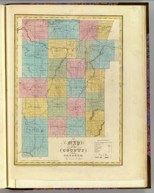
Author
Burr, David H., 1803-1875
Full Title
Map of the County of Genesee. By David H. Burr. Published by the Surveyor General, pursuant to an Act of the Legislature. Entered according to an Act of Congress Jany. 5th. 1829 by David H. Burr of the State of New York. Engd. by Rawdon, Clark & Co., Albany & Rawdon, Wright & Co., N. York.
Publisher
D.H. Burr
Author
Burr, David H., 1803-1875
Full Title
Map of the County of Allegany. By David H. Burr. Published by the Surveyor General, pursuant to an Act of the Legislature. Entered according to an Act of Congress Jany. 5th. 1829 by David H. Burr of the State of New York. Engd. by Rawdon, Clark & Co., Albany & Rawdon, Wright & Co., N. York.
Publisher
D.H. Burr
Author
Burr, David H., 1803-1875
Full Title
Map of the County of Niagara. By David H. Burr. Published by the Surveyor General, pursuant to an Act of the Legislature. Entered according to an Act of Congress Jany. 5th. 1829 by David H. Burr of the State of New York. Engd. by Rawdon, Clark & Co., Albany & Rawdon, Wright & Co., N. York.
Publisher
D.H. Burr
Author
Burr, David H., 1803-1875
Full Title
Map of the County of Erie. By David H. Burr. Published by the Surveyor General, pursuant to an Act of the Legislature. Entered according to an Act of Congress Jany. 5th. 1829 by David H. Burr of the State of New York. Engd. by Rawdon, Clark & Co., Albany & Rawdon, Wright & Co., New York.
Publisher
D.H. Burr
Author
Burr, David H., 1803-1875
Full Title
Map of the County of Cattaraugus. By David H. Burr. Published by the Surveyor General, pursuant to an Act of the Legislature. Entered according to an Act of Congress Jany. 5th. 1829 by David H. Burr of the State of New York. Engd. by Rawdon, Clark & Co., Albany & Rawdon, Wright & Co., N. York.
Publisher
D.H. Burr
Author
Burr, David H., 1803-1875
Full Title
Map of the County of Chautauque (sic). By David H. Burr. Published by the Surveyor General, pursuant to an Act of the Legislature. Entered according to an Act of Congress Jany. 5th. 1829 by David H. Burr of the State of New York. Engd. by Rawdon, Clark & Co., Albany & Rawdon, Wright & Co., New York.
Publisher
D.H. Burr
Author
Burr, David H., 1803-1875
Full Title
Map of the State of New-York and the surrounding country by David H. Burr. Compiled from his large map of the State, 1832. (with) Profile of the Grand Erie Canal. (with) Profile of the Champlain Canal. (with) Profile of the Seneca Canal. Entered according to Act of Congress Jany. 5th., 1829 by David H. Burr of the State of New York. Engd. by Rawdon, Clark & Co., Albany & Rawdon, Wright & Co., New York.
Publisher
D.H. Burr
Author
Burr, David H., 1803-1875
Full Title
Map of the City and County of New York with the adjacent country, by David H. Burr, published by Simeon DeWitt, Surveyor General, pursuant to an Act of the Legislature. Second edition 1832.
Publisher
D.H. Burr
|