Who What Where WhenREMOVEWHAT
WHEREShow More |
Author
[Lloyd, H.H., Warner & Beers]
Full Title
Atlas of Illinois, Counties of Douglas, Coles, Cumberland, Clark, & Edgar. Warner & Beers, Publishers.
Publisher
Warner & Beers
Author
[Lloyd, H.H., Warner & Beers]
Full Title
Atlas of Illinois, Counties of Jasper, Crawford, Lawrence, Richland, Edward & Wabash. Warner & Beers, Publishers.
Publisher
Warner & Beers
Author
[Lloyd, H.H., Warner & Beers]
Full Title
Atlas of Illinois, Counties of Fayette, Effingham, Clay & Marion. Warner & Beers, Publishers.
Publisher
Warner & Beers
Author
[Lloyd, H.H., Warner & Beers]
Full Title
Atlas of Illinois, Counties of Madison, Bond & Clinton. Warner & Beers, Publishers.
Publisher
Warner & Beers
Author
[Lloyd, H.H., Warner & Beers]
Full Title
Atlas of Illinois, Counties of St.Clair, Monroe, Randolph, Perry & Washington. Warner & Beers, Publishers.
Publisher
Warner & Beers
Author
[Lloyd, H.H., Warner & Beers]
Full Title
Atlas of Illinois, Counties of Wayne, Jefferson, Franklin, Hamilton and White. Warner & Beers, Publishers.
Publisher
Warner & Beers
Author
[Lloyd, H.H., Warner & Beers]
Full Title
Atlas of Illinois, Counties of Saline, Gallatin, Hardin, Pope & Massac. Warner & Beers, Publishers.
Publisher
Warner & Beers
Author
[Lloyd, H.H., Warner & Beers]
Full Title
Atlas of Illinois, Counties of Jackson, Williamson, Johnson, Union, Alexander & Pulaski. Warner & Beers, Publishers.
Publisher
Warner & Beers
Author
[Lloyd, H.H., Warner & Beers]
Full Title
Map of the United States. Warner & Beers, Publishers. From H.H. Lloyd & Co.'s Atlas of the United States.
Publisher
Warner & Beers
Author
[Lloyd, H.H., Warner & Beers]
Full Title
Atlas of the United States, New England, New York, and New Jersey. Warner & Beers, Publishers. From H.H. Lloyd & Co.'s Atlas of the United States.
Publisher
Warner & Beers
Author
[Lloyd, H.H., Warner & Beers]
Full Title
Atlas of the United States, Map of the Central States. Warner & Beers, Publishers. From H.H. Lloyd & Co.'s Atlas of the United States.
Publisher
Warner & Beers
Author
[Lloyd, H.H., Warner & Beers]
Full Title
Atlas of the United States, Map of the Western States. Warner & Beers, Publishers. From H.H. Lloyd & Co.'s Atlas of the United States.
Publisher
Warner & Beers
Author
[Lloyd, H.H., Warner & Beers]
Full Title
Atlas of the United States, Map of the Southern States. (inset) Map of Southern Florida. Warner & Beers, Publishers. From H.H. Lloyd & Co.'s Atlas of the United States.
Publisher
Warner & Beers
Author
[Lloyd, H.H., Warner & Beers]
Full Title
Atlas of the United States, Map of Texas. Warner & Beers, Publishers. From H.H. Lloyd & Co.'s Atlas of the United States.
Publisher
Warner & Beers
Author
[Lloyd, H.H., Warner & Beers]
Full Title
Atlas of the United States, Map of the Territory of Dakota, and the States of Minnesota, and Nebraska. Warner & Beers, Publishers. From H.H. Lloyd & Co.'s Atlas of the United States.
Publisher
Warner & Beers
Author
[Lloyd, H.H., Warner & Beers]
Full Title
Atlas of the United States, Map of the Montana, Idaho, and Wyoming. Warner & Beers, Publishers. From H.H. Lloyd & Co.'s Atlas of the United States.
Publisher
Warner & Beers
Author
[Lloyd, H.H., Warner & Beers]
Full Title
Atlas of the United States, Map of Utah, Arizona, New Mexico, Kansas, Colorado, and Indian Territory. Warner & Beers, Publishers. From H.H. Lloyd & Co.'s Atlas of the United States.
Publisher
Warner & Beers
Author
[Lloyd, H.H., Warner & Beers]
Full Title
Atlas of the United States, Map of Nevada and California. Warner & Beers, Publishers. From H.H. Lloyd & Co.'s Atlas of the United States.
Publisher
Warner & Beers
Author
[Lloyd, H.H., Warner & Beers]
Full Title
Atlas of the United States, Map of the Washington and Oregon. Territory of Alaska. Warner & Beers, Publishers. From H.H. Lloyd & Co.'s Atlas of the United States.
Publisher
Warner & Beers
Author
[Lloyd, H.H., Warner & Beers]
Full Title
Map of the West Indies. Warner & Beers, Publishers. From H.H. Lloyd & Co.'s Atlas of the United States.
Publisher
Warner & Beers
Author
[Lloyd, H.H., Warner & Beers]
Full Title
Western Hemisphere. Eastern Hemisphere.
Publisher
Warner & Beers
Author
[Lloyd, H.H., Warner & Beers]
Full Title
Morrison.
Publisher
Warner & Beers
Author
[Lloyd, H.H., Warner & Beers]
Full Title
Mt. Pleasant.
Publisher
Warner & Beers
Author
[Lloyd, H.H., Warner & Beers]
Full Title
Lyndon. (insets) Lyndon. Round Ground.
Publisher
Warner & Beers
Author
[Lloyd, H.H., Warner & Beers]
Full Title
Prophetstown.
Publisher
Warner & Beers
Author
[Lloyd, H.H., Warner & Beers]
Full Title
Newton. (inset) Mineral Springs.
Publisher
Warner & Beers
Author
[Lloyd, H.H., Warner & Beers]
Full Title
Garden Plain. (inset) Unionville.
Publisher
Warner & Beers
Author
[Lloyd, H.H., Warner & Beers]
Full Title
Fulton.
Publisher
Warner & Beers
Author
[Lloyd, H.H., Warner & Beers]
Full Title
Hopkins. (insets) Galt. Empire.
Publisher
Warner & Beers
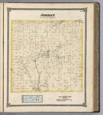
Author
[Lloyd, H.H., Warner & Beers]
Full Title
Jordan. (inset) Sanfordville.
Publisher
Warner & Beers
Author
[Gray, Ormando Willis, Lloyd, H.H., Walling, H. F.]
Full Title
Atlas of the United States. New England and New York. (Published by Stedman, Brown & Lyon, Cincinnati. 1872. Entered ... 1872, by H.F. Walling, and O.W. Gray, and H.H. Lloyd & Co. ... Washington)
Publisher
Stedman, Brown & Lyon
Author
[Gray, Ormando Willis, Lloyd, H.H., Walling, H. F.]
Full Title
Atlas of the United States. Delaware, Illinois, Indiana, Iowa, Kentucky, Maryland, Missouri, New Jersey, North Carolina, Ohio, Pennsylvania, Tennessee, Virginia and West Virginia. (Published by Stedman, Brown & Lyon, Cincinnati. 1872. Entered ... 1872, by H.F. Walling, and O.W. Gray, and H.H. Lloyd & Co. ... Washington)
Publisher
Stedman, Brown & Lyon
Author
[Gray, Ormando Willis, Lloyd, H.H., Walling, H. F.]
Full Title
Atlas of the United States. Michigan, Minnesota, and Wisconsin. (Published by Stedman, Brown & Lyon, Cincinnati. 1872. Entered ... 1872, by H.F. Walling, and O.W. Gray, and H.H. Lloyd & Co. ... Washington)
Publisher
Stedman, Brown & Lyon
Author
[Gray, Ormando Willis, Lloyd, H.H., Walling, H. F.]
Full Title
Atlas of the United States. Oregon, and the Territory of Washington. (Published by Stedman, Brown & Lyon, Cincinnati. 1872. Entered ... 1872, by H.F. Walling, and O.W. Gray, and H.H. Lloyd & Co. ... Washington)
Publisher
Stedman, Brown & Lyon
Author
[Gray, Ormando Willis, Lloyd, H.H., Walling, H. F.]
Full Title
Atlas of the United States. Nebraska, and the territories of Dakota, Idaho, Montana and Wyoming. (Published by Stedman, Brown & Lyon, Cincinnati. 1872. Entered ... 1872, by H.F. Walling, and O.W. Gray, and H.H. Lloyd & Co. ... Washington)
Publisher
Stedman, Brown & Lyon
Author
[Gray, Ormando Willis, Lloyd, H.H., Walling, H. F.]
Full Title
Atlas of the United States. California and Nevada. (Published by Stedman, Brown & Lyon, Cincinnati. 1872. Entered ... 1872, by H.F. Walling, and O.W. Gray, and H.H. Lloyd & Co. ... Washington)
Publisher
Stedman, Brown & Lyon
Author
[Gray, Ormando Willis, Lloyd, H.H., Walling, H. F.]
Full Title
Atlas of the United States. Texas. (Published by Stedman, Brown & Lyon, Cincinnati. 1872. Entered ... 1872, by H.F. Walling, and O.W. Gray, and H.H. Lloyd & Co. ... Washington)
Publisher
Stedman, Brown & Lyon
Author
[Gray, Ormando Willis, Lloyd, H.H., Walling, H. F.]
Full Title
Atlas of the United States. Kansas, and the territories of Arizona, Colorado, New Mexico, Utah, and Indian Territory. (Published by Stedman, Brown & Lyon, Cincinnati. 1872. Entered ... 1872, by H.F. Walling, and O.W. Gray, and H.H. Lloyd & Co. ... Washington)
Publisher
Stedman, Brown & Lyon
Author
[Gray, Ormando Willis, Lloyd, H.H., Walling, H. F.]
Full Title
Atlas of the United States. Alabama, Arkansas, Louisiana, and Mississippi. (Published by Stedman, Brown & Lyon, Cincinnati. 1872. Entered ... 1872, by H.F. Walling, and O.W. Gray, and H.H. Lloyd & Co. ... Washington)
Publisher
Stedman, Brown & Lyon
Author
[Gray, Ormando Willis, Lloyd, H.H., Walling, H. F.]
Full Title
Atlas of the United States. Florida, Georgia, and South Carolina. (Published by Stedman, Brown & Lyon, Cincinnati. 1872. Entered ... 1872, by H.F. Walling, and O.W. Gray, and H.H. Lloyd & Co. ... Washington)
Publisher
Stedman, Brown & Lyon
Author
[Gray, Ormando Willis, Lloyd, H.H., Walling, H. F.]
Full Title
(Covers to) New topographical atlas of the State of Ohio. With descriptions historical, scientific, and statistical, together with maps of the Untied States and territories. By H.F. Walling, and O.W. Gray, civil and topographical engineers. Published by Stedman, Brown & Lyon, Cincinnati. 1872. Entered ... 1872, by H.F. Walling, and O.W. Gray, and H.H. Lloyd & Co. ... Washington.
Publisher
Stedman, Brown & Lyon
Author
[Gray, Ormando Willis, Lloyd, H.H., Walling, H. F.]
Full Title
(Title Page to) New topographical atlas of the State of Ohio. With descriptions historical, scientific, and statistical, together with maps of the Untied States and territories. By H.F. Walling, and O.W. Gray, civil and topographical engineers. Published by Stedman, Brown & Lyon, Cincinnati. 1872. Entered ... 1872, by H.F. Walling, and O.W. Gray, and H.H. Lloyd & Co. ... Washington.
Publisher
Stedman, Brown & Lyon
Author
[Gray, Ormando Willis, Lloyd, H.H., Walling, H. F.]
Full Title
(Title Page Verso to) New topographical atlas of the State of Ohio. With descriptions historical, scientific, and statistical, together with maps of the Untied States and territories. By H.F. Walling, and O.W. Gray, civil and topographical engineers. Published by Stedman, Brown & Lyon, Cincinnati. 1872. Entered ... 1872, by H.F. Walling, and O.W. Gray, and H.H. Lloyd & Co. ... Washington.
Publisher
Stedman, Brown & Lyon
Author
[Gray, Ormando Willis, Lloyd, H.H., Walling, H. F.]
Full Title
(Contents to) New topographical atlas of the State of Ohio. With descriptions historical, scientific, and statistical, together with maps of the Untied States and territories. By H.F. Walling, and O.W. Gray, civil and topographical engineers. Published by Stedman, Brown & Lyon, Cincinnati. 1872. Entered ... 1872, by H.F. Walling, and O.W. Gray, and H.H. Lloyd & Co. ... Washington.
Publisher
Stedman, Brown & Lyon
Author
[Slater, J., Whittlesey, Chas.]
Full Title
Historical map of the State of Ohio. Showing the location of ancient earth works and the country occupied by the principal Indian tribes between 1750 and 1780 with their principal trails and war-paths by Col. Chas. Whittlesey, President of the Western Reserve and Northern Ohio Historical Society, Cleveland, Ohio, 1872. (with view) Ancient mound 2 miles east of Miamisburg, Montgomery Co., Ohio ... Photographed ... by J. Slater, 1872. (Published by Stedman, Brown & Lyon, Cincinnati. 1872. Entered ... 1872, by H.F. Walling, and O.W. Gray, and H.H. Lloyd & Co. ... Washington)
Publisher
Stedman, Brown & Lyon
Author
Newberry, John S.
Full Title
Geological map of Ohio by J.S. Newberry, Chief Geologist, 1872. (Published by Stedman, Brown & Lyon, Cincinnati. 1872. Entered ... 1872, by H.F. Walling, and O.W. Gray, and H.H. Lloyd & Co. ... Washington)
Publisher
Stedman, Brown & Lyon
Author
Klippart, J. H.
Full Title
Agricultural map of Ohio. Showing the distribution of soils, the localities of the principal productions, and the names and limits of the valleys and other natural divisions. By J.H. Klippart, Secretary of the Ohio State Board of Agriculture. 1872. (Published by Stedman, Brown & Lyon, Cincinnati. 1872. Entered ... 1872, by H.F. Walling, and O.W. Gray, and H.H. Lloyd & Co. ... Washington)
Publisher
Stedman, Brown & Lyon
Author
Blodget, Lorin
Full Title
Climatological map of the State of Ohio. By Lorin Blodget, 1872. (Published by Stedman, Brown & Lyon, Cincinnati. 1872. Entered ... 1872, by H.F. Walling, and O.W. Gray, and H.H. Lloyd & Co. ... Washington)
Publisher
Stedman, Brown & Lyon
Author
Bowen, B. F.
Full Title
City of Columbus, Franklin Co., Ohio. Drawn by B.F. Bowen, City Eng., Columbus, O., 1872. (Published by Stedman, Brown & Lyon, Cincinnati. 1872. Entered ... 1872, by H.F. Walling, and O.W. Gray, and H.H. Lloyd & Co. ... Washington)
Publisher
Stedman, Brown & Lyon
Author
Gray, Frank Arnold
Full Title
New rail road map of the State of Ohio, compiled and drawn by Frank Arnold Gray, 1872. (Published by Stedman, Brown & Lyon, Cincinnati. 1872. Entered ... 1872, by H.F. Walling, and O.W. Gray, and H.H. Lloyd & Co. ... Washington)
Publisher
Stedman, Brown & Lyon
|