Browse All

1893 Peck, Stow & Wilcox factories. State Atlas Factories of the Peck, Stow & Wilcox Co. … |

1909 Ohio. State Atlas Ohio. (Published by George F. Cram, Chic … |

1872 Cover: Ohio new topographical atlas. State Atlas (Covers to) New topographical atlas of t … |

1872 Title Page: New topographical atlas, Sta … State Atlas (Title Page to) New topographical atlas … |

1872 Title Page Verso: New topographical atla … State Atlas (Title Page Verso to) New topographical … |

1872 Contents: New topographical atlas, State … State Atlas (Contents to) New topographical atlas of … |

1872 Historical map of the State of Ohio. State Atlas Historical map of the State of Ohio. Sho … |

1872 Geological map of Ohio. State Atlas Geological map of Ohio by J.S. Newberry, … |

1872 Agricultural map of Ohio. State Atlas Agricultural map of Ohio. Showing the di … |

1872 Climatological map of the State of Ohio. State Atlas Climatological map of the State of Ohio. … |

1872 City of Columbus, Franklin Co., Ohio. State Atlas City of Columbus, Franklin Co., Ohio. Dr … |

1872 New rail road map of the State of Ohio. State Atlas New rail road map of the State of Ohio, … |

1872 Cleveland, Cayahoga Co. State Atlas Cleveland, Cayahoga Co. From data furnis … |

1872 Toledo, Lucas Co. State Atlas Toledo, Lucas Co. by J.B. Marston, C.E., … |
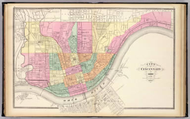
1872 City of Cincinnati, Ohio. State Atlas City of Cincinnati, Ohio. 1872. (Publish … |

1872 Dayton. State Atlas Dayton. (Published by Stedman, Brown & L … |

1872 Springfield, Clarke Co. State Atlas Springfield, Clarke Co. by J. Douglass M … |

1872 Cuyahoga, Erie, Huron, Lorain, Medina, O … State Atlas Topographical atlas of Ohio. Cuyahoga, E … |

1872 Ashtabula, Geauga, Lake, Mahoning, Porta … State Atlas Topographical atlas of Ohio. Ashtabula, … |

1872 Carroll, Columbiana, Harrison, Jefferson … State Atlas Topographical atlas of Ohio. Carroll, Co … |

1872 Athens, Belmont, Fairfield, Guernsey, Ho … State Atlas Topographical atlas of Ohio. Athens, Bel … |

1872 Gallia, Jackson, Lawrence, Meigs, and Vi … State Atlas Topographical atlas of Ohio. Gallia, Jac … |

1872 Adams, Brown, Highland, Pike, and Scioto … State Atlas Topographical atlas of Ohio. Adams, Brow … |

1872 Auglaize, Champaign, Clarke, Darke, Dela … State Atlas Topographical atlas of Ohio. Auglaize, C … |

1872 Clinton, Fayette, Greene, Pickaway, and … State Atlas Topographical atlas of Ohio. Clinton, Fa … |

1872 Butler, Clermont, Hamilton, Montgomery, … State Atlas Topographical atlas of Ohio. Butler, Cle … |

1872 Allen, Crawford, Defiance, Fulton, Hanco … State Atlas Topographical atlas of Ohio. Allen, Craw … |

1872 Ashland, Coshocton, Holmes, Knox, Richla … State Atlas Topographical atlas of Ohio. Ashland, Co … |

1870 Ohio, Indiana. [State Atlas, World Atlas] County map of Ohio and Indiana. Drawn an … |

1870 Cincinnati. [State Atlas, World Atlas] Plan of Cincinnati and vicinity. Entered … |