Browse All

1874 Map of Todd, Morrison, Crow Wing countie … State Atlas Map of the counties of Todd, Morrison, C … |

1874 Residence in Hutchinson, and residences … State Atlas Residence of W.T. Bonniwell, Hutchinson, … |

1874 Map of Wright County, Minn. State Atlas Map of Wright County, Minn. (Published b … |

1874 Map of Meeker County, Minn. State Atlas Map of Meeker County, Minn. (Published b … |

1874 Map of the City of St. Cloud ... Minneso … State Atlas Map of the City of St. Cloud, St. Cloud … |

1874 Map of Glencoe, Map of Henderson, Minn. State Atlas Map of Glencoe, Glencoe Township, McLeod … |

1874 Residences, church, hotel, school, jail, … State Atlas Residence of H.L. Gordon, St. Cloud ... … |

1874 Residences, farms, mill in and near Litc … State Atlas Fairview: farm residence of R.S. Hershey … |

1874 Manannah Mills, Manannah, and Forest Cit … State Atlas Manannah Mills, Hines and Butler, props. … |

1874 View of Public Park and residence, Litch … State Atlas View of Public Park, Litchfield, Minn. ( … |

1874 Map of Litchfield; Plan of Willmar; Brai … State Atlas Map of Litchfield, Meeker County, Minn. … |

1874 Map of Kandiyohi County. State Atlas Map of Kandiyohi County. (Published by A … |

1874 Map of Swift, Chippewa & Lac Qui Parle c … State Atlas Map of Swift, Chippewa & Lac Qui Parle c … |

1874 Counties of Renville, Redwood, Yellow Me … State Atlas Counties of Renville, Redwood, Yellow Me … |

1874 Counties of Grant, Traverse, Big Stone & … State Atlas Counties of Grant, Traverse, Big Stone & … |

1874 Counties of Clay, Wilkin, Becker, Otter … State Atlas Counties of Clay, Wilkin, Becker, Otter … |

1874 Map of Northern Minnesota, 1874. State Atlas Map of Northern Minnesota, 1874. (Publis … |

1874 Map of Douglas and Pope counties, Minn. State Atlas Map of Douglas and Pope counties, Minn. … |

1874 Map of Lanesboro, Map of Brownsville, Mi … State Atlas Map of Lanesboro, Fillmore Co., Minn. .. … |

1874 Map of Duluth, St. Louis Co., Minn. State Atlas Map of Duluth, St. Louis Co., Minn. (Pub … |

1874 Residence of C.A. de Graff, sec. 4, Alto … State Atlas Residence of C.A. de Graff, sec. 4, Alto … |

1874 Village of Preston, and South Ruthford a … State Atlas The Village of Preston, Fillmore County, … |

1874 Flour mills, Isenours; Glenwood and Lake … State Atlas John Kaercher's flour mills ... Isenours … |

1874 Lanesboro Company, Lanesboro, and reside … State Atlas View of water power of Lanesboro Company … |

1874 (Portraits of) Public men: W.W. Phelps, … State Atlas (Portraits of) Public men: W.W. Phelps, … |

1874 (Portraits of) Attorneys: W.M. McCluer, … State Atlas (Portraits of) Attorneys: W.M. McCluer, … |

1874 (Portraits of) Early settlers: Chris Gra … State Atlas (Portraits of) Early settlers: Chris Gra … |

1874 (Portraits of) Early settlers of Minneso … State Atlas (Portraits of) Early settlers of Minneso … |

1874 (Portraits of) Early settlers: Henry S. … State Atlas (Portraits of) Early settlers: Henry S. … |

1874 (Portraits of) Early settlers: Pierre Bo … State Atlas (Portraits of) Early settlers: Pierre Bo … |

1874 (Portraits of) Early settlers: D. Morris … State Atlas (Portraits of) Early settlers: D. Morris … |

1870 Covers: Asher & Adams' New Topographical … State Atlas (Covers to) Asher & Adams' New Topograph … |

1880 Covers: Illustrated Historical Atlas Of … State Atlas (Covers to) Illustrated Historical Atlas … |

1880 Table of Contents and Title Page: Illust … State Atlas (Table of Contents and Title Page) Illus … |

1880 Text Page: Historical Sketch of the Prov … State Atlas (Text Page) Historical Sketch of the Pro … |

1880 Text Page: Historical Sketch of the Prov … State Atlas (Text Page) Historical Sketch of the Pro … |

1880 Text Page: Historical Sketch of the Prov … State Atlas (Text Page) Historical Sketch of the Pro … |

1880 Text Page: Historical Sketch of the Prov … State Atlas (Text Page) Historical Sketch of the Pro … |

1880 Text Page: Historical Sketch of the Prov … State Atlas (Text Page) Historical Sketch of the Pro … |

1880 Text Page: Historical Sketch of the Prov … State Atlas (Text Page) Historical Sketch of the Pro … |

1880 Dominion of Canada (Eastern Sheet). State Atlas Dominion of Canada (Eastern Sheet). |

1880 Dominion of Canada (Western Sheet). State Atlas Dominion of Canada (Western Sheet). |

1880 Representatives of the Press (portraits) … State Atlas Representatives of the Press (portraits) … |
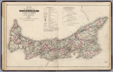
1880 Province of Prince Edward Island in the … State Atlas Map of the Province of Prince Edward Isl … |

1880 Buildings, Charlottetown, Prince Edward … State Atlas Lieut. Governors Residence, Charlottetow … |

1880 Plan of Lot One, Prince Co., P.E.I. State Atlas Plan of Lot One, Prince Co., P.E.I. (ins … |

1880 Residences, P.E.I. State Atlas "Belmont Farm" Residence of Benj. E. Wri … |

1880 Plan of Lot Six, Prince Co., P.E.I. State Atlas Plan of Lot Six, Prince Co., P.E.I. (ins … |

1880 Plan of Lots Two & Three, Prince County, … State Atlas Plan of Lots Two & Three, Prince County, … |

1880 Bank of Prince Edward Island, Ch'town, P … State Atlas Bank of Prince Edward Island, Ch'town, P … |