Browse All

1873 (Map of Bay County, Michigan) State Atlas (Map of Bay County, Michigan. Drawn, com … |

1873 (Map of Midland County, Michigan) State Atlas (Map of Midland County, Michigan. Drawn, … |

1873 (Map of Isabella County, Michigan) State Atlas (Map of Isabella County, Michigan. Drawn … |

1873 (Map of Mecosta County, Michigan) State Atlas (Map of Mecosta County, Michigan. Drawn, … |

1873 (Map of Newaygo County, Michigan) State Atlas (Map of Newaygo County, Michigan. Drawn, … |

1873 (Map of Oceana County, Michigan) State Atlas (Map of Oceana County, Michigan. Drawn, … |

1873 (Map of Muskegon County, Michigan) State Atlas (Map of Muskegon County, Michigan. Drawn … |

1873 (Map of Montcalm County, Michigan) State Atlas (Map of Montcalm County, Michigan. Drawn … |

1873 (Map of Gratiot County, Michigan) State Atlas (Map of Gratiot County, Michigan. Drawn, … |

1873 (Map of Saginaw County, Michigan) State Atlas (Map of Saginaw County, Michigan. Drawn, … |

1873 (Map of Tuscola County, Michigan) State Atlas (Map of Tuscola County, Michigan. Drawn, … |

1873 (Map of Huron County, Michigan) State Atlas (Map of Huron County, Michigan. Drawn, c … |

1873 (Map of Sanilac County, Michigan) State Atlas (Map of Sanilac County, Michigan. Drawn, … |

1873 (Map of St. Clair County, Michigan) State Atlas (Map of St. Clair County, Michigan. Draw … |

1873 (Map of Lapeer County, Michigan) State Atlas (Map of Lapeer County, Michigan. Drawn, … |

1873 (Map of Genesee County, Michigan) State Atlas (Map of Genesee County, Michigan. Drawn, … |

1873 (Map of Shiawassee County, Michigan) State Atlas (Map of Shiawassee County, Michigan. Dra … |

1873 (Map of Clinton County, Michigan) State Atlas (Map of Clinton County, Michigan. Drawn, … |

1873 (Map of Ionia County, Michigan) State Atlas (Map of Ionia County, Michigan. Drawn, c … |

1873 (Map of Kent County, Michigan) State Atlas (Map of Kent County, Michigan. Drawn, co … |

1873 (Map of Ottawa County, Michigan) State Atlas (Map of Ottawa County, Michigan. Drawn, … |

1873 (Map of Allegan County, Michigan) State Atlas (Map of Allegan County, Michigan. Drawn, … |

1873 (Map of Barry County, Michigan) State Atlas (Map of Barry County, Michigan. Drawn, c … |

1873 (Map of Eaton County, Michigan) State Atlas (Map of Eaton County, Michigan. Drawn, c … |
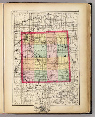
1873 (Map of Ingham County, Michigan) State Atlas (Map of Ingham County, Michigan. Drawn, … |

1873 (Map of Livingston County, Michigan) State Atlas (Map of Livingston County, Michigan. Dra … |

1873 (Map of Oakland County, Michigan) State Atlas (Map of Oakland County, Michigan. Drawn, … |
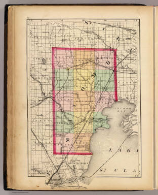
1873 (Map of Macomb County, Michigan) State Atlas (Map of Macomb County, Michigan. Drawn, … |

1873 (Map of Wayne County, Michigan) State Atlas (Map of Wayne County, Michigan. Drawn, c … |

1873 (Map of Washtenaw County, Michigan) State Atlas (Map of Washtenaw County, Michigan. Draw … |

1873 (Map of Jackson County, Michigan) State Atlas (Map of Jackson County, Michigan. Drawn, … |

1873 (Map of Calhoun County, Michigan) State Atlas (Map of Calhoun County, Michigan. Drawn, … |

1873 (Map of Kalamazoo County, Michigan) State Atlas (Map of Kalamazoo County, Michigan. Draw … |

1873 (Map of Van Buren County, Michigan) State Atlas (Map of Van Buren County, Michigan. Draw … |

1873 (Map of Berrien County, Michigan) State Atlas (Map of Berrien County, Michigan. Drawn, … |

1873 (Map of Cass County, Michigan) State Atlas (Map of Cass County, Michigan. Drawn, co … |

1873 (Map of St. Joseph County, Michigan) State Atlas (Map of St. Joseph County, Michigan. Dra … |

1873 (Map of Branch County, Michigan) State Atlas (Map of Branch County, Michigan. Drawn, … |

1873 (Map of Hillsdale County, Michigan) State Atlas (Map of Hillsdale County, Michigan. Draw … |

1873 (Map of Lenawee County, Michigan) State Atlas (Map of Lenawee County, Michigan. Drawn, … |

1873 (Map of Monroe County, Michigan) State Atlas (Map of Monroe County, Michigan. Drawn, … |

1873 Upper Peninsula, scale six miles to an i … State Atlas Upper Peninsula, scale six miles to an i … |

1873 Upper Peninsula, scale six miles to an i … State Atlas Upper Peninsula, scale six miles to an i … |

1873 Upper Peninsula, scale six miles to an i … State Atlas Upper Peninsula, scale six miles to an i … |

1873 Upper Peninsula, scale six miles to an i … State Atlas Upper Peninsula, scale six miles to an i … |

1873 Upper Peninsula, scale six miles to an i … State Atlas Upper Peninsula, scale six miles to an i … |

1873 Upper Peninsula, scale six miles to an i … State Atlas Upper Peninsula scale six miles to an in … |

1873 Upper Peninsula, scale six miles to an i … State Atlas Upper Peninsula scale six miles to an in … |

1873 Upper Peninsula, scale six miles to an i … State Atlas Upper Peninsula scale six miles to an in … |

1873 Map of the City of Detroit. State Atlas Map of the City of Detroit, 1873. Compil … |