Browse All

1875 Residences and office, Douglas Tp., and … State Atlas Residence of O.E. Doubleday, Douglas Tp. … |

1872 Atlas of Illinois, Counties of Sangamon, … [National Atlas, State Atlas] Atlas of Illinois, Counties of Sangamon, … |

1875 Residences of J. Justice, Delaware, and … State Atlas Residence of James Justice, Delaware, Po … |

1872 Atlas of Illinois, Counties of Macon, Ch … [National Atlas, State Atlas] Atlas of Illinois, Counties of Macon, Ch … |

1872 Atlas of Illinois, Counties of Douglas, … [National Atlas, State Atlas] Atlas of Illinois, Counties of Douglas, … |

1875 Map of Floyd County, State of Iowa. State Atlas Map of Floyd County, State of Iowa. Chas … |

1872 Atlas of Illinois, Counties of Jasper, C … [National Atlas, State Atlas] Atlas of Illinois, Counties of Jasper, C … |

1872 Atlas of Illinois, Counties of Fayette, … [National Atlas, State Atlas] Atlas of Illinois, Counties of Fayette, … |

1875 Plans of Cedar Falls, Waterloo, Hopkinto … State Atlas Plan of Cedar Falls, Blackhawk Co., Iowa … |

1872 Atlas of Illinois, Counties of Madison, … [National Atlas, State Atlas] Atlas of Illinois, Counties of Madison, … |

1872 Atlas of Illinois, Counties of St.Clair, … [National Atlas, State Atlas] Atlas of Illinois, Counties of St.Clair, … |

1875 Map of Chickasaw County, State of Iowa. State Atlas Map of Chickasaw County, State of Iowa. … |

1872 Atlas of Illinois, Counties of Wayne, Je … [National Atlas, State Atlas] Atlas of Illinois, Counties of Wayne, Je … |

1875 Plans of Cedar Falls, Waterloo, Hopkinto … State Atlas Plan of Iowa Falls ... Hardin Co. (with) … |

1872 Atlas of Illinois, Counties of Saline, G … [National Atlas, State Atlas] Atlas of Illinois, Counties of Saline, G … |

1872 Atlas of Illinois, Counties of Jackson, … [National Atlas, State Atlas] Atlas of Illinois, Counties of Jackson, … |

1875 Nashua; farm and residence, West Liberty … State Atlas Nashua, Chickasaw Co., Iowa. (with) C.S. … |

1872 Map of the United States. [National Atlas, State Atlas] Map of the United States. Warner & Beers … |

1872 Atlas of the United States, New England, … [National Atlas, State Atlas] Atlas of the United States, New England, … |

1872 Atlas of the United States, Map of the C … [National Atlas, State Atlas] Atlas of the United States, Map of the C … |
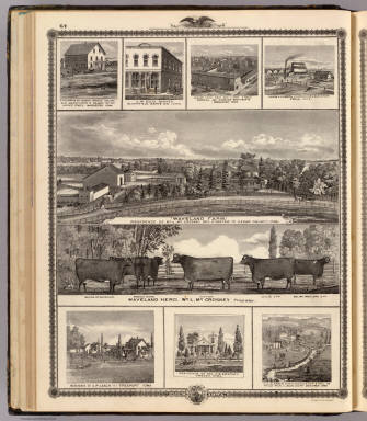
1875 Farms, businesses, residences, Cedar Cou … State Atlas "Waveland Farm," residence of Wm. L. Cro … |

1872 Atlas of the United States, Map of the W … [National Atlas, State Atlas] Atlas of the United States, Map of the W … |

1872 Atlas of the United States, Map of the S … [National Atlas, State Atlas] Atlas of the United States, Map of the S … |

1872 Texas. [National Atlas, State Atlas] Atlas of the United States, Map of Texas … |

1872 Territory of Dakota, Minnesota, and Nebr … [National Atlas, State Atlas] Atlas of the United States, Map of the T … |

1875 Morning scene, J.D. Rivers stock farm, D … State Atlas Morning scene on the large stock farm of … |

1872 Montana, Idaho, and Wyoming. [National Atlas, State Atlas] Atlas of the United States, Map of the M … |

1872 Utah, Arizona, New Mexico, Kansas, Color … [National Atlas, State Atlas] Atlas of the United States, Map of Utah, … |

1875 Farm, residences & pipe works, Delaware, … State Atlas Stock farm & residence of H.H. Taylor, D … |

1872 Nevada and California. [National Atlas, State Atlas] Atlas of the United States, Map of Nevad … |

1872 Washington and Oregon. Territory of Alas … [National Atlas, State Atlas] Atlas of the United States, Map of the W … |

1872 West Indies. [National Atlas, State Atlas] Map of the West Indies. Warner & Beers, … |

1875 Map of Franklin County, State of Iowa. State Atlas Map of Franklin County, State of Iowa. C … |

1872 Western Hemisphere. Eastern Hemisphere [National Atlas, State Atlas] Western Hemisphere. Eastern Hemisphere. |

1872 Morrison, Whiteside County, Illinois. [National Atlas, State Atlas] Morrison. |

1872 Mt. Pleasant Township, Whiteside County, … [National Atlas, State Atlas] Mt. Pleasant. |

1872 Lyndon Township, Whiteside County, Illin … [National Atlas, State Atlas] Lyndon. (insets) Lyndon. Round Ground. |

1872 Prophetstown Township, Whiteside County, … [National Atlas, State Atlas] Prophetstown. |

1872 Newton Township, Whiteside County, Illin … [National Atlas, State Atlas] Newton. (inset) Mineral Springs. |

1875 Map of Bremer County, Plan of Waverly, S … State Atlas Map of Bremer County, State of Iowa. (wi … |

1872 Garden Plain Township, Whiteside County, … [National Atlas, State Atlas] Garden Plain. (inset) Unionville. |

1872 Fulton Township, Whiteside County, Illin … [National Atlas, State Atlas] Fulton. |

1872 Hopkins Township, Whiteside County, Illi … [National Atlas, State Atlas] Hopkins. (insets) Galt. Empire. |
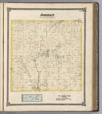
1872 Jordan Township, Whiteside County, Illin … [National Atlas, State Atlas] Jordan. (inset) Sanfordville. |

1875 Map of Butler County, State of Iowa. State Atlas Map of Butler County, State of Iowa. Cha … |

1875 Map of Black Hawk County, State of Iowa. State Atlas Map of Black Hawk County, State of Iowa. … |

1875 Residences, farm, businesses in W. Liber … State Atlas Maple Hill Herd: residence and stock far … |

1875 (Portraits of) J.C. Knapp, J.G. Vale, Da … State Atlas (Portraits of) J.C. Knapp, J.G. Vale, Da … |

1875 Residences and store in Polk County, Pol … State Atlas Residence of Newton Thornton, Douglas Tp … |

1875 Farm residence of I. Lee & residence of … State Atlas Farm residence of Ishmael Lee ... (with) … |