Browse All

1938 Covers: Thomas Bros. Recreational and St … [State Atlas, Statistical Atlas] (Covers to) Thomas Bros. Recreational an … |

1938 (Front cover liner) Index of Maps. [State Atlas, Statistical Atlas] (Front cover liner) Index of Maps. |

1938 View: Mammoth Lakes in the High Sierras. [State Atlas, Statistical Atlas] (View) Mammoth Lakes in the High Sierras … |

1938 View: Lake County California, The Switze … [State Atlas, Statistical Atlas] (View) Lake County California, The Switz … |

1938 View: (Alameda County). [State Atlas, Statistical Atlas] (View) (Alameda County). |

1938 (County and Road) Map of California. [State Atlas, Statistical Atlas] (County and Road) Map of California. |

1938 Highways of the Western States. [State Atlas, Statistical Atlas] Highways of the Western States. |

1938 Highway Map of the State of Oregon. [State Atlas, Statistical Atlas] Highway Map of the State of Oregon. |

1938 Thomas Bros. Highway Map, State of Washi … [State Atlas, Statistical Atlas] Thomas Bros. Highway Map, State of Washi … |

1938 Highway Map State of Idaho. [State Atlas, Statistical Atlas] Highway Map State of Idaho. (inset) City … |

1938 Highway Map States of Utah and Nevada. [State Atlas, Statistical Atlas] Highway Map States of Utah and Nevada. |

1938 Highway Map State of Arizona. [State Atlas, Statistical Atlas] Highway Map State of Arizona. |
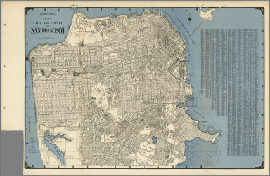
1938 City and County of San Francisco. [State Atlas, Statistical Atlas] Thomas Bros. Map of the City and County … |

1938 Map of Oakland, Berkeley, Alameda, San L … [State Atlas, Statistical Atlas] Map of Oakland, Berkeley, Alameda, San L … |

1938 Daly City, South San Francisco, San Brun … [State Atlas, Statistical Atlas] Thomas Bros: Map of Daly City, South San … |

1938 Thomas Bros. Map of the Major Part of th … [State Atlas, Statistical Atlas] Thomas Bros. Map of the Major Part of th … |

1938 Map of Palo Alto, Redwood City, Mountain … [State Atlas, Statistical Atlas] Map of Palo Alto, Redwood City, Mountain … |

1938 San Mateo, Burlingame, Hillsborough, San … [State Atlas, Statistical Atlas] San Mateo, Burlingame, Hillsborough, San … |

1938 Los Altos. Saratoga. Monte Vista. Los Ga … [State Atlas, Statistical Atlas] (verso of) Thomas Bros Map of San Jose, … |

1938 Thomas Bros Map of San Jose, Santa Clara … [State Atlas, Statistical Atlas] Thomas Bros Map of San Jose, Santa Clara … |

1938 Thomas Bros. Map of Hayward and Vicinity … [State Atlas, Statistical Atlas] Thomas Bros. Map of Hayward and Vicinity … |

1938 Map of Richmond, El Cerrito, San Pablo, … [State Atlas, Statistical Atlas] Map of Richmond, El Cerrito, San Pablo, … |

1938 Thomas Bros Walnut Creek, Concord, Lafay … [State Atlas, Statistical Atlas] Thomas Bros Walnut Creek, Concord, Lafay … |

1938 Thomas Bros. Map of Stockton, California … [State Atlas, Statistical Atlas] Thomas Bros. Map of Stockton. |

1938 Thomas Bros. Map of City of Tracy, San J … [State Atlas, Statistical Atlas] Thomas Bros. Map of City of Tracy, San J … |

1938 Map of Sacramento, California. [State Atlas, Statistical Atlas] Map of Sacramento. |

1938 Thomas Bros.' Map of Vallejo and Vicinit … [State Atlas, Statistical Atlas] Thomas Bros.' Map of Vallejo and Vicinit … |

1938 City of Napa, California. [State Atlas, Statistical Atlas] The City of Napa. |

1938 Thomas Bros. Map of Sausalito, Marin Cou … [State Atlas, Statistical Atlas] Thomas Bros. Map of Sausalito, Marin Cou … |

1938 Thomas Bros.', Map of Mill Valley, Marin … [State Atlas, Statistical Atlas] Thomas Bros.', Map of Mill Valley, Marin … |

1938 Thomas Bros Map of San Rafael, San Ansel … [State Atlas, Statistical Atlas] Thomas Bros Map of San Rafael, San Ansel … |

1938 City of Petaluma, Sonoma County, Califor … [State Atlas, Statistical Atlas] The City of Petaluma, Sonoma County, Cal … |

1938 Map of Santa Rosa and Vicinity, Californ … [State Atlas, Statistical Atlas] Map of Santa Rosa and Vicinity. |

1938 Thomas Bros Map of Eureka and Vicinity, … [State Atlas, Statistical Atlas] Thomas Bros Map of Eureka and Vicinity. |

1938 Map of Martinez and Vicinity, Contra Cos … [State Atlas, Statistical Atlas] Map of Martinez and Vicinity, Contra Cos … |

1938 Map of Pittsburg, Contra Costa County, C … [State Atlas, Statistical Atlas] Map of Pittsburg, Contra Costa County. |

1938 Thomas Bros. Map of Roseville, Placer Co … [State Atlas, Statistical Atlas] Thomas Bros. Map of Roseville, Placer Co … |

1938 Thomas Bros. Map of Woodland, Yolo Count … [State Atlas, Statistical Atlas] Thomas Bros. Map of Woodland, Yolo Count … |

1938 Thomas Bros. Map of Monterey, Carmel, Pa … [State Atlas, Statistical Atlas] Thomas Bros. Map of Monterey, Carmel, Pa … |

1938 Thomas Bros. Map of Carmel-by-the-Sea, M … [State Atlas, Statistical Atlas] Thomas Bros. Map of Carmel-by-the-Sea, M … |

1938 City of Watsonville, California. [State Atlas, Statistical Atlas] The City of Watsonville, California. |

1938 Thomas Bros. Map of the City of Santa Cr … [State Atlas, Statistical Atlas] Thomas Bros. Map of the City of Santa Cr … |

1938 Map of Modesto, California, Compiled & P … [State Atlas, Statistical Atlas] Map of Modesto, Compiled & Published by … |

1938 Thomas Bros. Map of City of Turlock, Sta … [State Atlas, Statistical Atlas] Thomas Bros. Map of City of Turlock, Sta … |

1938 Thomas Bros. Map of Fresno, California. [State Atlas, Statistical Atlas] Thomas Bros. Map of Fresno. |

1938 Thomas Bros Map of Hanford, California. [State Atlas, Statistical Atlas] Thomas Bros Map of Hanford. |

1938 Thomas Bros. Map of City of Visalia, Cal … [State Atlas, Statistical Atlas] Thomas Bros. Map of City of Visalia. |

1938 Thomas Bros. Map of Tulare, California. [State Atlas, Statistical Atlas] Thomas Bros. Map of Tulare. |

1938 Index Map: Guide to Street Location and … [State Atlas, Statistical Atlas] (Index Map) Guide to Street Location and … |

1938 Index: (Los Angeles Streets). [State Atlas, Statistical Atlas] (Index Page) (Los Angeles Streets). |