Who What Where WhenREMOVEWHO
WHEN
|
Author
Stieler, Adolf
Full Title
(Text Page) Beilage C. Zu No. 5a und 5b. Der Nordliche und Sudliche Gestirnte Himmel. Beilage D. (Zur Karte No. 10.) Die Berkannteren Hohen Uber Der Meeresflache in Transparenten Profilen etc. (Mountain Profiles),
Publisher
Justus Perthes
Author
Stieler, Adolf
Full Title
(Text Page) Beilage D. (Zur Karte No. 10.) Die Berkannteren Hohen Uber Der Meeresflache in Transparenten Profilen etc. (Mountain Profiles),
Publisher
Justus Perthes
Author
Stieler, Adolf
Full Title
(Text Page) Beilage D. (Zur Karte No. 10.) Die Berkannteren Hohen Uber Der Meeresflache in Transparenten Profilen etc. (Mountain Profiles),
Publisher
Justus Perthes
Author
Stieler, Adolf
Full Title
(Text Page) Beilage D. (Zur Karte No. 10.) Die Berkannteren Hohen Uber Der Meeresflache in Transparenten Profilen etc. (Mountain Profiles). Beilage E. Zu No. 13a. Spanien und Portugal. Neue Bearbeitung 1834 - 1837.
Publisher
Justus Perthes
Author
Stieler, Adolf
Full Title
(Text Page) Beilage E. Zu No. 13a. Spanien und Portugal. Neue Bearbeitung 1834 - 1837. Beilage F. Zu No 14b,c,d. Systematishes Verzeichniss der vorzuglichsten Gebirge und Berge Frankreichs.
Publisher
Justus Perthes
Author
Stieler, Adolf
Full Title
(Text Page) Beilage F. Zu No 14b,c,d. Systematishes Verzeichniss der vorzuglichsten Gebirge und Berge Frankreichs.
Publisher
Justus Perthes
Author
Stieler, Adolf
Full Title
(Text Page) Beilage F. Zu No 14b,c,d. Systematishes Verzeichniss der vorzuglichsten Gebirge und Berge Frankreichs. Beilage G. Zu No. 35b und 35a. Erlauterungen zur Karte von Ungarn und Siebenburgen.
Publisher
Justus Perthes
Author
Stieler, Adolf
Full Title
(Text Page) Beilage G. Zu No. 35b und 35a. Erlauterungen zur Karte von Ungarn und Siebenburgen.
Publisher
Justus Perthes
Author
Stieler, Adolf
Full Title
(Text Page) Beilage G. Zu No. 35b und 35a. Erlauterungen zur Karte von Ungarn und Siebenburgen.
Publisher
Justus Perthes
Author
Stieler, Adolf
Full Title
(Text Page) Beilage G. Zu No. 35b und 35a. Erlauterungen zur Karte von Ungarn und Siebenburgen.
Publisher
Justus Perthes
Author
Stieler, Adolf
Full Title
(Text Page) Vorbemerkungen zur XVIten Supplement Lieferungoder XIten Lieferung neuer Bearbeilungen von Stieler's Hand-Atlas. Juni 1850.
Publisher
Justus Perthes
Author
Stieler, Adolf
Full Title
(Text Page) Vorbemerkungen zur XVIten Supplement Lieferungoder XIten Lieferung neuer Bearbeilungen von Stieler's Hand-Atlas. Juni 1850.
Publisher
Justus Perthes
Author
Tanner, Henry S.
Full Title
(Geographical Memoir, pg. 1 in) A New American Atlas Containing Maps Of The Several States of the North American Union, Projected and drawn on a Uniform Scale from Documents found in the public Offices of the United States and State Governments, and other Original and Authentic Information, By Henry S. Tanner ... Philadelphia: Published By H.S. Tanner. 1823. (title page only) Writing Drawn and Engraved by Joseph Perkins. Barralet del. Humphrys sc.
Publisher
Henry Tanner
Author
Tanner, Henry S.
Full Title
(Geographical Memoir, pgs. 2-3 in) A New American Atlas Containing Maps Of The Several States of the North American Union, Projected and drawn on a Uniform Scale from Documents found in the public Offices of the United States and State Governments, and other Original and Authentic Information, By Henry S. Tanner ... Philadelphia: Published By H.S. Tanner. 1823. (title page only) Writing Drawn and Engraved by Joseph Perkins. Barralet del. Humphrys sc.
Publisher
Henry Tanner
Author
Tanner, Henry S.
Full Title
(Geographical Memoir, pgs. 4-5 in) A New American Atlas Containing Maps Of The Several States of the North American Union, Projected and drawn on a Uniform Scale from Documents found in the public Offices of the United States and State Governments, and other Original and Authentic Information, By Henry S. Tanner ... Philadelphia: Published By H.S. Tanner. 1823. (title page only) Writing Drawn and Engraved by Joseph Perkins. Barralet del. Humphrys sc.
Publisher
Henry Tanner
Author
Tanner, Henry S.
Full Title
(Geographical Memoir, pgs. 6-7 in) A New American Atlas Containing Maps Of The Several States of the North American Union, Projected and drawn on a Uniform Scale from Documents found in the public Offices of the United States and State Governments, and other Original and Authentic Information, By Henry S. Tanner ... Philadelphia: Published By H.S. Tanner. 1823. (title page only) Writing Drawn and Engraved by Joseph Perkins. Barralet del. Humphrys sc.
Publisher
Henry Tanner
Author
Tanner, Henry S.
Full Title
(Geographical Memoir, pgs. 8-9 in) A New American Atlas Containing Maps Of The Several States of the North American Union, Projected and drawn on a Uniform Scale from Documents found in the public Offices of the United States and State Governments, and other Original and Authentic Information, By Henry S. Tanner ... Philadelphia: Published By H.S. Tanner. 1823. (title page only) Writing Drawn and Engraved by Joseph Perkins. Barralet del. Humphrys sc.
Publisher
Henry Tanner
Author
Tanner, Henry S.
Full Title
(Geographical Memoir, pgs. 10-11 in) A New American Atlas Containing Maps Of The Several States of the North American Union, Projected and drawn on a Uniform Scale from Documents found in the public Offices of the United States and State Governments, and other Original and Authentic Information, By Henry S. Tanner ... Philadelphia: Published By H.S. Tanner. 1823. (title page only) Writing Drawn and Engraved by Joseph Perkins. Barralet del. Humphrys sc.
Publisher
Henry Tanner
Author
Tanner, Henry S.
Full Title
(Geographical Memoir, pgs. 12-13 in) A New American Atlas Containing Maps Of The Several States of the North American Union, Projected and drawn on a Uniform Scale from Documents found in the public Offices of the United States and State Governments, and other Original and Authentic Information, By Henry S. Tanner ... Philadelphia: Published By H.S. Tanner. 1823. (title page only) Writing Drawn and Engraved by Joseph Perkins. Barralet del. Humphrys sc.
Publisher
Henry Tanner
Author
Tanner, Henry S.
Full Title
(Geographical Memoir, pgs. 14-15 in) A New American Atlas Containing Maps Of The Several States of the North American Union, Projected and drawn on a Uniform Scale from Documents found in the public Offices of the United States and State Governments, and other Original and Authentic Information, By Henry S. Tanner ... Philadelphia: Published By H.S. Tanner. 1823. (title page only) Writing Drawn and Engraved by Joseph Perkins. Barralet del. Humphrys sc.
Publisher
Henry Tanner
Author
Tanner, Henry S.
Full Title
(Geographical Memoir, pgs. 16-17 in) A New American Atlas Containing Maps Of The Several States of the North American Union, Projected and drawn on a Uniform Scale from Documents found in the public Offices of the United States and State Governments, and other Original and Authentic Information, By Henry S. Tanner ... Philadelphia: Published By H.S. Tanner. 1823. (title page only) Writing Drawn and Engraved by Joseph Perkins. Barralet del. Humphrys sc.
Publisher
Henry Tanner
Author
Tanner, Henry S.
Full Title
(Geographical Memoir, pg. 18 in) A New American Atlas Containing Maps Of The Several States of the North American Union, Projected and drawn on a Uniform Scale from Documents found in the public Offices of the United States and State Governments, and other Original and Authentic Information, By Henry S. Tanner ... Philadelphia: Published By H.S. Tanner. 1823. (title page only) Writing Drawn and Engraved by Joseph Perkins. Barralet del. Humphrys sc.
Publisher
Henry Tanner
Author
Tanner, Henry S.
Full Title
(Geographical Memoir, pg. 1 in) A New American Atlas Containing Maps Of The Several States of the North American Union, Projected and drawn on a Uniform Scale from Documents found in the public Offices of the United States and State Governments, and other Original and Authentic Information, By Henry S. Tanner ... Philadelphia: Published By H.S. Tanner. 1825. (title page only). Barralet del. Humphrys sc. Joseph Perkins, Philadelphia.
Publisher
Henry Tanner
Author
Tanner, Henry S.
Full Title
(Geographical Memoir, pgs. 2-3 in) A New American Atlas Containing Maps Of The Several States of the North American Union, Projected and drawn on a Uniform Scale from Documents found in the public Offices of the United States and State Governments, and other Original and Authentic Information, By Henry S. Tanner ... Philadelphia: Published By H.S. Tanner. 1825. (title page only). Barralet del. Humphrys sc. Joseph Perkins, Philadelphia.
Publisher
Henry Tanner
Author
Tanner, Henry S.
Full Title
(Geographical Memoir, pgs. 4-5 in) A New American Atlas Containing Maps Of The Several States of the North American Union, Projected and drawn on a Uniform Scale from Documents found in the public Offices of the United States and State Governments, and other Original and Authentic Information, By Henry S. Tanner ... Philadelphia: Published By H.S. Tanner. 1825. (title page only). Barralet del. Humphrys sc. Joseph Perkins, Philadelphia.
Publisher
Henry Tanner
Author
Tanner, Henry S.
Full Title
(Geographical Memoir, pgs. 6-7 in) A New American Atlas Containing Maps Of The Several States of the North American Union, Projected and drawn on a Uniform Scale from Documents found in the public Offices of the United States and State Governments, and other Original and Authentic Information, By Henry S. Tanner ... Philadelphia: Published By H.S. Tanner. 1825. (title page only). Barralet del. Humphrys sc. Joseph Perkins, Philadelphia.
Publisher
Henry Tanner
Author
Tanner, Henry S.
Full Title
(Geographical Memoir, pgs. 8-9 in) A New American Atlas Containing Maps Of The Several States of the North American Union, Projected and drawn on a Uniform Scale from Documents found in the public Offices of the United States and State Governments, and other Original and Authentic Information, By Henry S. Tanner ... Philadelphia: Published By H.S. Tanner. 1825. (title page only). Barralet del. Humphrys sc. Joseph Perkins, Philadelphia.
Publisher
Henry Tanner
Author
Tanner, Henry S.
Full Title
(Geographical Memoir, pgs. 10-11 in) A New American Atlas Containing Maps Of The Several States of the North American Union, Projected and drawn on a Uniform Scale from Documents found in the public Offices of the United States and State Governments, and other Original and Authentic Information, By Henry S. Tanner ... Philadelphia: Published By H.S. Tanner. 1825. (title page only). Barralet del. Humphrys sc. Joseph Perkins, Philadelphia.
Publisher
Henry Tanner
Author
Tanner, Henry S.
Full Title
(Geographical Memoir, pgs. 12-13 in) A New American Atlas Containing Maps Of The Several States of the North American Union, Projected and drawn on a Uniform Scale from Documents found in the public Offices of the United States and State Governments, and other Original and Authentic Information, By Henry S. Tanner ... Philadelphia: Published By H.S. Tanner. 1825. (title page only). Barralet del. Humphrys sc. Joseph Perkins, Philadelphia.
Publisher
Henry Tanner
Author
Tanner, Henry S.
Full Title
(Geographical Memoir, pgs. 14-15 in) A New American Atlas Containing Maps Of The Several States of the North American Union, Projected and drawn on a Uniform Scale from Documents found in the public Offices of the United States and State Governments, and other Original and Authentic Information, By Henry S. Tanner ... Philadelphia: Published By H.S. Tanner. 1825. (title page only). Barralet del. Humphrys sc. Joseph Perkins, Philadelphia.
Publisher
Henry Tanner
Author
Tanner, Henry S.
Full Title
(Geographical Memoir, pgs. 16-17 in) A New American Atlas Containing Maps Of The Several States of the North American Union, Projected and drawn on a Uniform Scale from Documents found in the public Offices of the United States and State Governments, and other Original and Authentic Information, By Henry S. Tanner ... Philadelphia: Published By H.S. Tanner. 1825. (title page only). Barralet del. Humphrys sc. Joseph Perkins, Philadelphia.
Publisher
Henry Tanner
Author
Tanner, Henry S.
Full Title
(Geographical Memoir, pg. 18 in) A New American Atlas Containing Maps Of The Several States of the North American Union, Projected and drawn on a Uniform Scale from Documents found in the public Offices of the United States and State Governments, and other Original and Authentic Information, By Henry S. Tanner ... Philadelphia: Published By H.S. Tanner. 1825. (title page only). Barralet del. Humphrys sc. Joseph Perkins, Philadelphia.
Publisher
Henry Tanner
Author
U.S. Office of War Information
Full Title
(Text Page to) A War Atlas for Americans. Prepared with the Assistance of the Office of War Information. Published for Council on Books in Wartime by Simon and Schuster. New York. 1944.
Publisher
Simon and Schuster
Author
U.S. Office of War Information
Full Title
(Text Page to) A War Atlas for Americans. Prepared with the Assistance of the Office of War Information. Published for Council on Books in Wartime by Simon and Schuster. New York. 1944.
Publisher
Simon and Schuster
Author
U.S. Office of War Information
Full Title
(Text Page to) A War Atlas for Americans. Prepared with the Assistance of the Office of War Information. Published for Council on Books in Wartime by Simon and Schuster. New York. 1944.
Publisher
Simon and Schuster
Author
U.S. Office of War Information
Full Title
(Text Page to) A War Atlas for Americans. Prepared with the Assistance of the Office of War Information. Published for Council on Books in Wartime by Simon and Schuster. New York. 1944.
Publisher
Simon and Schuster
Author
Debenham, Frank
Full Title
(Text Page to) Introduction: The global atlas; a new view of the world from space. By Frank Debenham, Professor Emeritus of Geography, University of Cambridge. Introduction by Bertrand Russell. Produced by Geographical Project Ltd., London. (Published by): Simon and Schuster, New York. (verso of title page) Copyright 1958, Adprint Ltd., London. Printed in the U.S.A. by Western Printing and Lithographing Company. Published by Simon and Schuster, Inc., Rockefeller Center, New York 20, N.Y. ... (on opposite page) Decorative cartouche from Joillot's map of Palestine 1691.
Publisher
Simon and Schuster
Author
Debenham, Frank
Full Title
(Text Page to) About this book: The global atlas; a new view of the world from space. By Frank Debenham, Professor Emeritus of Geography, University of Cambridge. Introduction by Bertrand Russell. Produced by Geographical Project Ltd., London. (Published by): Simon and Schuster, New York. (verso of title page) Copyright 1958, Adprint Ltd., London. Printed in the U.S.A. by Western Printing and Lithographing Company. Published by Simon and Schuster, Inc., Rockefeller Center, New York 20, N.Y. ... (on opposite page) Primitive map: Marshall Island's bamboo and shell chart.
Publisher
Simon and Schuster
Author
Debenham, Frank
Full Title
(Text Page to) About this book: The global atlas; a new view of the world from space. By Frank Debenham, Professor Emeritus of Geography, University of Cambridge. Introduction by Bertrand Russell. Produced by Geographical Project Ltd., London. (Published by): Simon and Schuster, New York. (verso of title page) Copyright 1958, Adprint Ltd., London. Printed in the U.S.A. by Western Printing and Lithographing Company. Published by Simon and Schuster, Inc., Rockefeller Center, New York 20, N.Y. ...
Publisher
Simon and Schuster
Author
Debenham, Frank
Full Title
(Text Page to) Self-Centered Maps.
Publisher
Simon and Schuster
Author
Debenham, Frank
Full Title
(Text Page to) Ptolemy's "Geography".
Publisher
Simon and Schuster
Author
Debenham, Frank
Full Title
(Text Page to) East and West.
Publisher
Simon and Schuster
Author
Debenham, Frank
Full Title
(Text Page to) Mountains on maps.
Publisher
Simon and Schuster
Author
Debenham, Frank
Full Title
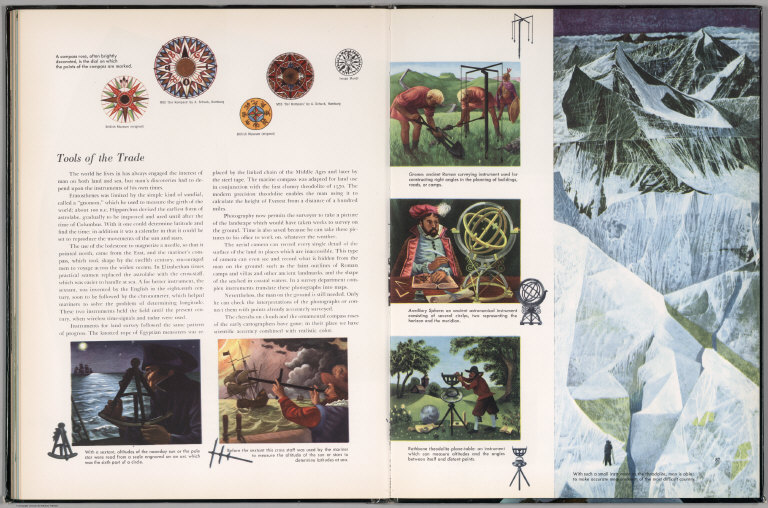
(Text Page to) Tools of the trade. (with inset view).
Publisher
Simon and Schuster
Author
Debenham, Frank
Full Title
(Text Page to) On the Land. (with inset view).
Publisher
Simon and Schuster
Author
Debenham, Frank
Full Title
(Text Page to) Under the Land. (with inset view).
Publisher
Simon and Schuster
Author
Debenham, Frank
Full Title
(Text Page to) Under the Sea.
Publisher
Simon and Schuster
Author
Debenham, Frank
Full Title
(Text Page to) Under the Sea.
Publisher
Simon and Schuster
Author
Debenham, Frank
Full Title
(Text Page to) In the Air. (with serial photographs)
Publisher
Simon and Schuster
Author
[Matthews-Northrup Division, J.W. Clement Co.]
Full Title
(Text Page to) Insignia of the U.S. Army. Insignia of the U.S. Navy. (to accompany) The New Matthews-Northrup Global atlas of the World at War. Cartography and manufacturing by J. W. Clement Co., Matthews-Northrup Works, Buffalo, N.Y. Copyright, 1943, by the World Publishing Company. (on verso) Published in the United States of America.
Publisher
World Publishing Company
|