|
|
REFINE
Browse All : Title Page and Chart Atlas
1-16 of 16
Author
France. Depot-general de la Marine
Full Title
(Title Page to) Neptune des cotes occidentales d'Amerique sur le Grand Ocean.
Publisher
Depot de la Marine
Author
Vancouver, George, 1757-1798
Full Title
(Title Page to) A Voyage Of Discovery To The North Pacific Ocean And Round The World In Which The Coast of North-West America Has Been Carefully Examined And Accurately Surveyed. Undertaken by His Majesty's Command, Principally With A View To Ascertain The Existence Of Any Navigable Communication Between The North Pacific and North Atlantic Oceans; And Performed In The Years 1790, 1791, 1792, 1793, 1794, and 1795 In The Discovery Sloop Of War, And Armed Tender Chatham, Under The Command Of Captain George Vancouver. In Three Volumes. London: Printed For G.G. And J. Robinson, Paternoster-Row; And J. Edwards, Pall-Mall. 1798.
Publisher
G.G. & J. Robinson
Author
Roux, Joseph
Full Title
(Title Page to) Carte De La Mer Mediterranee en Douze Fueilles. Dediee a Mgr. Le Duc De Choiseul Colonel General des Suisses et Grisons Ministre de la Guerre et de la Marine, Par son tres humble Serviteur Joseph Roux Hydrographe du Roy, sur le Port a St. Jean, a Marseille, Avec Privilege du Roy. 1764. Premiere Feuille.
Publisher
J. Roux.
Author
Bache, A. D.
Full Title
(Title Page to) Maps and charts of the United States Coast Survey. A.D. Bache, Superintendent. To July, 1854.
Publisher
U.S.
Author
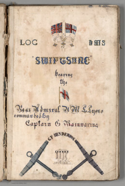
[Mainwaring, C., Henderson, C.F.]
Full Title
(Title Page) Log Of H.M.S. "Swiftsure" Bearing the (flag of) Rear Admiral H.M.L. Lyons commanded by Captain C. Mainwaring. C.F. Henderson.
Publisher
N.P: Manuscript
Author
Bellin, Jacques Nicolas, 1703-1772
Full Title
(Title Pasge to) Le Petit Atlas Maritime Tome IV. Contenat L'Europe, et les Divers Etats qu'elle Renferme Except la France.
Publisher
J.N. Bellin
Author
Bellin, Jacques Nicolas, 1703-1772
Full Title
(Title Page to) Le Petit Atlas Maritime Tome V. Contenat Les Costes De France et Les Places Maritimes sur l'Ocean et sur la Mediterranee.
Publisher
J.N. Bellin
Author
Bellin, Jacques Nicolas, 1703-1772
Full Title
(Title Page to) Le Petit Atlas Maritime Recueil De Cartes et Plans Des Quatre Parties Du Monde, en Cinq Volumes.
Publisher
J.N. Bellin
Author
Bellin, Jacques Nicolas, 1703-1772
Full Title
(Title Page 2 to) Le Petit Atlas Maritime Recueil De Cartes et Plans Des Quatre Parties Du Monde Premier Volume Contenant L'Amerique Septentrionale et Isles Antilles.
Publisher
J.N. Bellin
Author
Bellin, Jacques Nicolas, 1703-1772
Full Title
(Title Page to) Le Petit Atlas Maritime Recueil De Cartes et Plans Des Quatre Parties Du Monde. Second Volume. Contentant, L'Amerique Meridionale. et ses Details.
Publisher
J.N. Bellin
Author
Bellin, Jacques Nicolas, 1703-1772
Full Title
(Title Page to) Le Petit Atlas Maritime Recueil De Cartes et Plans Des Quatre Parties Du Monde. Tome III. Contenant, I, L' Asie, II, L' Afrique. Avec les details interessans de ces Deux Parties. M, DCC, LXIV.
Publisher
J.N. Bellin
Author
Bellin, Jacques Nicolas, 1703-1772
Full Title
(Title page to) Seconde Partie du Tome III, Conmtenant L'Afrique. Avec des Details tant sur La Mer Mediterranee que sur l'Ocean, et Les Isles Qui en Dependent. M.DCC.LXIV. (engraved by) Arrivet.
Publisher
J.N. Bellin
Author
Deutsche Seewarte
Full Title
(Title Page to) Deutsche Seewarte. Atlantischer Ozean. Ein atlas von 39 karten, die physikalischen verhaltnisse und die verkehrs-strassen darstellend, mit einer erlauternden einleitung und als beilage zum segelhandbuch fur den Atlantischen Ozean. Zweite Auflage. Herausgegeben von der Direktion. Hamburg: L. Friederichsen & Co. (Inhaber: Dr. L. Friederichsen.) 1902.
Publisher
L. Friederichsen & Co.
Author
Arrowsmith, Aaron
Full Title
(Covers and Title Label to) Complete Neptune, to Illustrate, by Arrowsmith, The Progress of Maritime Discovery. Part I. (Containing five Charts).
Publisher
Cadell & Davies
Author
Ringgold, Cadwalader.
Full Title
(Title Page) A Series of Charts, With Sailing Directions, Embracing Surveys of the Farallones, Entrance to the Bay of San Francisco ... State of California. By Cadwalader Ringgold, Commander, U.S. Navy. Washington: Printed by Jno. T. Towers, 1851. (on verso) Entered ... 1851, by Cadwalader Ringgold ... District of Columbia.
Publisher
Jno. T. Towers
Author
La Perouse, Jean-Francois de Galaup, comte de, 1741-1788
Full Title
(Title Page to) Atlas du voyage de La Perouse. Dessine par J. M. Moreau le Jeune. Grave par Ph. Triere. L. Aubert scripsit.
Publisher
L'Imprimerie de la Republique
1-16 of 16
|