Who What Where WhenREMOVEWHERE |
Author
Berghaus, Heinrich
Full Title
(Title Page to Vol. 2) Dr. Heinrich Berghaus' Physikalischer Atlas oder Sammlung von Karten, auf denen die hauptsachlichsten Erscheinungen der anorganischen und organischen Natur nach ihrer geographischen Verbreitung und Vertheilung bildlich dargestellt sind ... 1845. Verlag von Justus Perthes in Gotha ... 1848 ...
Publisher
Justus Perthes
Author
Colton, G.W.
Full Title
(Title Page to) Colton's Atlas Of The World, Illustrating Physical And Political Geography. By George W. Colton. Accompanied By Descriptions Geographical, Statistical, And Historical, By Richard Swainson Fisher, M.D. Complete In One Volume. New York: J.H. Colton And Company, No. 172 William, Corner Beekman Street. London: Trubner And Company, No. 12 Paternoster Row. 1856. Entered ... One Thousand Eight Hundred and Fifty-five, by J.H. Colton And Company ... New York.
Publisher
J.H. Colton
Author
Cary, John, ca. 1754-1835
Full Title
(Title Page to) Cary's new universal atlas, containing distinct maps of all the principal states and kingdoms throughout the World. From the latest and best authorities extant. London: Printed for J. Cary, Engraver and Map-seller, No. 181, near Norfolk Street, Strand, 1808.
Publisher
John Cary
Author
Cram, George Franklin
Full Title
(Title Page to) Cram's Standard American Atlas Of The World. Accompanied By A Complete And Simple Index ... Maps Of The United States Are The Largest Scale And Clearest Print Of Any Atlas Maps Published. Foreign Maps Are Compiled Largely From Charts Of The Royal Geographical Society, And Are Geographically Correct. George F. Cram, No. 19 Park Place, New York. Wm.M. Goldthwaite, Manager.
Publisher
George F. Cram
Author
Johnston, Alexander Keith, 1804-1871
Full Title
(Title Page to) The royal atlas of modern geography, exhibiting, in a series of entirely original and authentic maps, the present condition of geographical discovery and research in the several countries, empires, and states of the world by Alexander Keith Johnston ... With a special index to each map. William Blackwood and Sons, Edinburgh and London. MDCCCLXI.
Publisher
William Blackwood & Sons
Author
Society for the Diffusion of Useful Knowledge (Great Britain)
Full Title
(Title Page to) Maps of the Society for the Diffusion of Useful Knowledge. Vol. 2. London: Chapman and Hall, 186, Strand, 1844. (verso: London: printed by William Clowes and Son, Stamford Street)
Publisher
Chapman and Hall
Author
Colton, G.W.
Full Title
(Title Page to) Colton's General Atlas Of The World, Containing Two Hundred And Twelve Maps And Plans, On One Hundred And Forty-Two Imperial Folio Sheets, Drawn By G. Woolworth Colton. Accompanied By Geographical, Statistical, And Historical Letter-Press Descriptions. New York: G.W. & C.B. Colton & Co., No. 182 William Street. 1886. Entered ... 1876, By G.W. & C.B. Colton & Co. ... Washington.
Publisher
G. W & C. B. Colton & Co.
Author
Colton, G.W.
Full Title
(Title Page to) Colton's General Atlas, Containing One Hundred And Eighty Steel Plate Maps And Plans, On One Hundred And Nineteen Imperial Folio Sheets, Drawn By G. Woolworth Colton. Letter-Press Descriptions, Geographical, Statistical, And Historical, By Richard Swainson Fisher. New York: G.W. & C.B. Colton, No. 172 William Street. 1874. Entered ... 1863, by J.H. Colton ... New York.
Publisher
G. W & C. B. Colton & Co.
Author
Colton, G.W.
Full Title
(Title Page to) Colton's General Atlas, Containing One Hundred And Eighty Steel Plate Maps And Plans, On One Hundred And Nineteen Imperial Folio Sheets, Drawn By G. Woolworth Colton. Letter-Press Descriptions, Geographical, Statistical, And Historical, By Richard Swainson Fisher. New York: G.W & J.H. Colton, No. 172 William Street. London: Bacon & Co., 48 Paternoster Row. 1866. Entered ... 1863, by J.H. Colton ... New York.
Publisher
G.W. & C.B. Colton
Author
Schonberg & Co.
Full Title
(Title Page to) Schonberg's Standard Atlas Of The World. New York, Schonberg And Company. 1865. Boston: Benj. B. Russell, 515 Washington St. Chicago: R.R. Landon, Agent, 88 Lake St. (on verso) ... Entered ... 1863, by Schonberg & Co. ... New York.
Publisher
Schonberg & Co.
Author
Raisz, Erwin
Full Title
(Title Page to) Atlas Of Global Geography. By Erwin Raisz. Lectures in Cartography, Institute Of Geographical Exploration, Harvard University, Cambridge, Mass. ... Global Press Corporation, Publishers. New York, N.Y. Sole Distributors: Harper & Brothers, New York. (on verso) Copyright 1944, by Global Press Corporation.
Publisher
Global Press Corp.
Author
Garnier, F. A., 1803-1863
Full Title
(Title Page to) Atlas spheroidal et universel de geographie dresse a l'aide des documents officiels, recemment publies en France et a l'etranger par M.F.A. Garnier, Membre de la Societe de Geographie, etc. Paris, Veuve Jules Renouard, Libraire, Editeur de A. Balbi, Abrege de Geographie; A. Guibert, Dictionnaire de Geographie; Dufour et Jomard, Le Globe, etc. Rue de Tournon, 6, Faubourg Saint-Germain. MDCCCLXII.
Publisher
Veuve Jules Renouard, Libraire
Author
Harrison, Richard Edes
Full Title
(Title Page to) Look At The World: The Fortune Atlas For world Strategy. By Richard Edes Harrison. Text by Editor of Fortune. New York: Alfred A. Knopf 1944. (on verso) Copyright 1944 by Time Incorporated. Atlas exhibiting large scale maps, drawn from the point of view of the air age. Dust Cover showing a relief map of japan in full color. (on verso of dust cover) Text containing a short description of the atlas, biography and picture of Richard. E. Harrison. Atlas, Contains full color, and black and white maps and plans. Drawn By Richard Edes Harrison. With Geographical, Statistical, And Historical Descriptions.
Publisher
A. A. Knopf
Author
Johnson, A.J.
Full Title
(Title Page to) Johnson's New Illustrated (Steel Plate) Family Atlas, With Physical Geography, And With Descriptions Geographical, Statistical, And Historical ... By Richard Swainson Fisher, M.D. ... Maps Compiled, Drawn, And Engraved Under The Supervision Of J.H. Colton And A.J. Johnson. New York: Johnson And Ward, Successors To Johnson And Browning (Successors To J.H. Colton And Company,) No. 113 Fulton Street. 1864. Entered ... One Thousand Eight Hundred and Sixty-four, by A.J. Johnson ... New York.
Publisher
Johnson and Ward
Author
Arrowsmith, Aaron
Full Title
(Title page to) A New General Atlas, Constructed from the latest Authorities, By A. Arrowsmith, Hydrographer to the Prince Regent, Exhibiting The Boundaries And Divisions, Also The Chains of Mountains and other Geographical Features Of All The Known Countries In The World; Comprehended In Fifty Three Maps From Original Drawings. Edinburgh, Published, 1817 by A. Constable & Co. And By Longman & Compy., London. (title page only) Hy. Corbould delt. Chas. Heath sculpt. Sidy. Hall script. Bury Stt. Bloomsby.
Publisher
[A. Constable & Co., Longman & Compy]
Author
[Jones, C.H., Hamilton, T.H., Williams, J.David]
Full Title
(Title Page to) The Peoples' Pictorial Atlas. Being A Complete And Popular Account Of All The Countries Of The World, In Their Geographical, Statistical, Topographical And Commercial Aspects. With 52 Maps. Constructed By A. Keith Johnston, F.R.G.S.; Prof. H.D. Rogers, of Boston; Edward Weller, F.R.G.S., and Other Eminent Geographers. Compiled and Edited By Charles H. Jones, Assisted By Theodore F. Hamilton. New York: J. David Williams, Publisher, 46 Beekman Street. 1873. [Entered ... 1873, by J. David Williams ... Washington, D.C.]
Publisher
J. David Williams
Author
Hall, S. (Sidney)
Full Title
(Title Page to) A new general atlas, with the divisions and boundaries carefully coloured; Constructed entirely from new drawings, and engraved by Sidney Hall. (1st ed.). London, printed for Longman, Rees, Orme, Brown and Green, Paternoster Row, 1830.
Publisher
Longman, Rees, Orme, Brown and Green
Author
Hall, S. (Sidney)
Full Title
(Contents to) A new general atlas, with the divisions and boundaries carefully coloured; Constructed entirely from new drawings, and engraved by Sidney Hall. (1st ed.). London, printed for Longman, Rees, Orme, Brown and Green, Paternoster Row, 1830.
Publisher
Longman, Rees, Orme, Brown and Green
Author
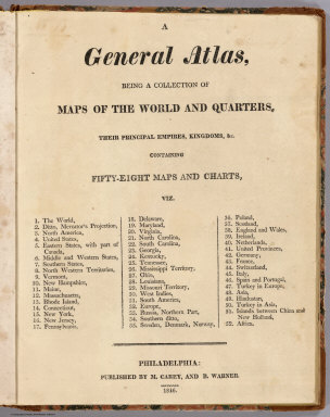
[Carey, Mathew, Warner, Benjamin]
Full Title
(Title Page to) A General Atlas, Being A Collection Of Maps Of The World And Quarters, Their Principal Empires, Kingdoms, &c. Containing Fifty Eight Maps And Charts. Philadelphia: Published By M. Carey, And B. Warner. 1816.
Publisher
M. Carey and B. Warner
Author
[Bayer, Herbert, Container Corporation of America]
Full Title
(Title Page) World Geo-graphic Atlas, A Composite of Man's Environment. Geography, Geology, Demography, Astronomy, Climatology, Economics. Privately printed for Container Corporation of America, 1953, edited and designed by herbert bayer.
Publisher
Container Corporation of America
Author
Johnson, A.J.
Full Title
(Title Page to) Johnson's New Illustrated Family Atlas Of The World, Was Awarded The First Prize Medal At The Universal Exposition Of 1867, In Paris, With A Treatise On Physical Geography, By A. Guyot, LL.D. ... With Descriptions, Geographical, Statistical, And Historical ... A Dictionary Of Religious Denominations, Sects, Parties, And Associations, Compiled By Professor Roswell D. Hitchcock, D.D. ... New York: A.J. Johnson, Publisher, 276 & 278 Mulberry Street. 1870. Entered ... One Thousand Eight Hundred and Seventy, by A.J. Johnson ... New York.
Publisher
A.J. Johnson
Author
Ruhle von Lilienstern, August
Full Title
(Title Page) Allgemeiner Schulatlas v. R v. L. Berlin, 1825.
Publisher
C.G. Luderitz
Author
Morse, Sidney E.
Full Title
(Covers to) The Cerographic Missionary Atlas. Published By Sidney E. Morse & Co., Gratuitously and Exclusively For The Subscribers To The New York Observer. (on verso) Entered .. 1848, By S.E. Morse & Co. ... New York.
Publisher
Sidney E. Morse
Author
Tanner, Henry S.
Full Title
(Title Page to) A New American Atlas Containing Maps Of The Several States of the North American Union, Projected and drawn on a Uniform Scale from Documents found in the public Offices of the United States and State Governments, and other Original and Authentic Information, By Henry S. Tanner ... Philadelphia: Published By Henry S. Tanner. 1825.
Publisher
Henry Tanner
Author
[Bourquin, Frederick, Mitchell, Samuel Augustus, Tanner, Henry S.]
Full Title
(Title Page to) A New Universal Atlas Containing Maps of the various Empires, Kingdoms, States and Republics Of The World. With a special map of each of the United States, Plans of Cities &c. Comprehended in seventy sheets and forming a series of One Hundred And Seventeen Maps, Plans And Sections ... Philadelphia, Published By S. Augustus Mitchell, N.E. corner of Market & 7th Streets. Entered ... 1844, by Carey & Hart ... Pennsylvania. (title page by) J. Knight Sc. Barralet del. Humphreys sc.
Publisher
S. Augustus Mitchell.
Author
Lucas, Fielding Jr.
Full Title
(Title Page to) A New and Elegant General Atlas Containing Maps of each of the United States. Baltimore. Printed and Published By Fielding Lucas Junr. and Philip H. Nicklin Philadelphia. Copyright Secured. G. Fairman. (1816)
Publisher
[Fielding Lucas, Philip H. Nicklin.]
Author
Greenleaf, Jeremiah
Full Title
(Title Page to) A New Universal Atlas; Comprising Separate Maps Of all the Principal Empires, Kingdoms & States Throughout the World: and forming a distinct Atlas Of The United States. Carefully Compiled from the best Authorities Extant by Jeremiah Greenleaf. a new edition revised and corrected to the present time. 1848.
Publisher
J. Greenleaf.
Author
Darton, William
Full Title
(Title Page to) 38 maps. Union atlas, containing new and improved maps of all the empires, kingdoms, & states, in the known world, designed as a companion to the various gazetteers & books of geography now in use, the whole clearly engraved by artists of eminence and carefully coloured. Including maps of the Roman Empire and Ancient Greece. Published Jany. 25th, 1812, by William Darton, 58 Holborn Hill, London. (1813)
Publisher
William Darton
Author
Stanford, Edward
Full Title
(Title Page to) Stanford's London atlas of universal geography exhibiting the physical and political divisions of the various countries of the world. Folio edition. One hundred maps, with a list of latitudes and longitudes. Second issue, revised and enlarged. London, Edward Stanford, Geographer to Her Majesty, 12, 13 & 14 Long Acre, W.C. 1901.
Publisher
Edward Stanford
Author
Burr, David H., 1803-1875
Full Title
(Title Page to) A New Universal Atlas; Comprising Separate Maps Of all the Principal Empires, Kingdoms & States Throughout the World: and forming a distinct Atlas Of The United States. Carefully Compiled from the best Authorities Extant by David H. Burr. Published by D.S. Stone, N. York. Printed by Cammeyer & Clark, N.Y.
Publisher
D.S. Stone
Author
[Berghaus, Heinrich, Flemming, Carl, Sohr, Karl]
Full Title
(Title Page to) Vollstandiger Hand-Atlas der neueren Erdbeschreibung uber alle Theile der Erde in 82 Blattern herausgegben von Dr. K. Sohr. Vt. Auflage vermehrt und verbessert durch Dr. Heinrich Berghaus, Professor u. Director der geograph. Kunstschule zu Potsdam. Glogau und Leipzig 1855. Druck u. Verlag von C. Flemming. (with) Supplementband, 32 Blattern.
Publisher
C. Flemming
Author
[Brue, Adrien Hubert, 1786-1832, Picquet, C.]
Full Title
(Title Page to) Atlas universel de geographie physique, politique, ancienne & moderne. Contenant les cartes generales et particulieres de toutes les parties du monde ... Dedie a l'Academie Royale des Sciences de l'Institut de France ... Nouvelle edition composee de soixante cinq feuilles. Par A. Brue, Geographe du Roi. Revue et augmentee par Chles. Picquet, Geographe du Roi et de Mgr. le Duc d'Orleans. Paris, chez Ch. Picquet ... Proprietaire des cartes et atlas de fonds de Mr. Brue, seul charge de la vente des cartes, plans, &a., publies par le Depot Genal. de la Guerre, Quai Conti No. 17, pres du Pont des Arts. (1842?)
Publisher
C. Picquet
Author
Stein, Christ. Gottfr. Dan.
Full Title
(Title Page to) Neuer Atlas der ganzen Erde fur die Gebildeten aller Stande und fur hohere Lehranstalten. Zweiunddreissigste Auflage. Achtundzwanzig Karten, mit Berucksichtigung der geographisch-statistischen Werke von Dr. C.G.D. Stein und Anderen, entworfen und gezeichnet von J.M. Ziegler, Dr. H. Lange, G. Heck u.A., nebst siebzehn Zeittafeln und dreissig statistischen Tabellen uber alle Lander und Staaten der Erde, begrundet von Prof. Dr. K. Th. Wagner, neu bearbeitet und erganzt von O. Delitsch und Prof. Dr. H.F. Brachelli. Leipzig, J.C. Hinrichs'sche Buch- und Landkartenhandlung. (1865)
Publisher
J.C. Hinrichs'sche Buch- und Landkartenhandlung
Author
Playfair, Principal
Full Title
(Title Page to) A New General Atlas, Ancient and Modern; Accurately Constructed, by Principal Playfair, St. Andrews, and Elegantly Engraved by the most eminent Artists in London. London: Printed for The Author; and Sold By T. Underwood, Fleet Street, London; and P. Hill, Edinburgh. 1814.
Publisher
[P. Hill, T. Underwood]
Author
DeSilver, Robert
Full Title
(Title Page to) A new and approved general atlas of the World. Philadelphia: Published by Robert Desilver, 110 Walnut Street. 1822.
Publisher
Robert DeSilver
Author
Philip, George
Full Title
(Title Page to) New mercantile marine atlas. A series of 35 plates containing over 200 charts and plans with tables of 12,000 distances between ports. Supplemented by a new and original diagrammatic chart for calculating speed, time & distance; national and commercial flags, cable, oiling stations and wireless telegraphy charts with list of wireless stations, and complete index of over 20,000 ports, &c. Specially designed for merchant shippers, exporters & ocean travellers and for general use. Edited by George Philip, F.R.G.S. Ninth edition. C.S. Hammond & Company, publishers, New York City, U.S.A. London: George Philip & Son, Ltd., the London Geographical Institute, 32 Fleet Street, E.C. Liverpool: Philip, Son & Nephew, Ltd., 20 Church St. (1922)
Publisher
[C.S. Hammond & Company. London: George Philip & Son, Ltd. The London Geographical Institute, Philip, Son & Nephew, Ltd.]
Author
Fullarton, A. & Co.
Full Title
(Title Page to) The Royal Illustrated Atlas, Of Modern Geography With An Introductory Notice By Dr. N. Shaw, Secretary To The Royal Geographical Society &c. A. Fullarton And Co. London And Edinburgh. (title page only) W.B. Scott. W. Holl.
Publisher
A. Fullarton & Co.
Author
Reichard, C. G.
Full Title
(Title Page to) Atlas des ganzen Erdkreises nach den besten astronomischen Bestimmungen neusten Entdeckungen und eigenen Untersuchungen in der Central-Projection auf sechs Tafeln entworfen von Christian Gottlieb Reichard. Weimar. Im Verlage des Landes Industrie Comptoirs. 1803.
Publisher
Landes Industrie Comptoir
Author
Arrowsmith, John
Full Title
(Title Page to) The London atlas of universal geography, exhibiting the physical & political divisions of the various countries of the World, constructed from original materials. Is most respectfully dedicated to his venerable friend John Middleton Esqr. As a testimony of gratitude and esteem, by his much obliged & humble servant, John Arrowsmith, F.R.G.S. & R.A.S. 35, Essex Street, Strand, London. London, pubd. by J. Arrowsmith ... 1838.
Publisher
John Arrowsmith
Author
Brue, Adrien Hubert, 1786-1832
Full Title
(Title Page to) Atlas universel de geographie physique, politique, ancienne & moderne. Contenant les cartes generales et particulieres de toutes les parties du monde ... Dedie a l'Academie Royale des Sciences de l'Institut de France ... Seconde edition composee de soixante cinq feuilles. Par A. Brue, Geographe du Roi, membre de la Societe Philomatique, de la Commission centrale de la Societe Geographique &a. Paris, 1828. chez l'Auteur, rue des Macons Sorbonne, No. 9, & chez les principaux marchands de cartes geographiques. (with label) a Paris, Chez Chles. Picquet, Geographe, Quai de Conti pres le Pont des Arts No. 17.
Publisher
A. Brue
Author
Lucas, Fielding Jr.
Full Title
(Title Page to) A General Atlas, Of All The Known Countries In The World. Baltimore: Published by Fielding Lucas, Junr. No. 138, Market Street. (1822)
Publisher
Fielding Lucas
Author
Melish, John
Full Title
(Title Page to) A General Collection Of Maps, Charts, Views, &c. ... Philadelphia. 1824.
Publisher
No publisher.
Author
Kitchin, Thomas
Full Title
(Title Page to) A general atlas, describing the whole universe: being a complete collection of the most approved maps extant; corrected with the greatest care, and augmented from the latest discoveries. The whole being an improvement of the maps of D'Anville and Robert. Engraved in the best manner on sixty-two copper-plates, by Thomas Kitchin, Senior, and Others. London: printed For Robert Sayer, no. 53, Fleet-Street, (1790).
Publisher
Robert Sayer
Author
Houze, Antoine Philippe
Full Title
(Title Page to) Atlas universel historique et geographique compose de cent une cartes, donnant les differentes divisions et modifications territoriales des diverses nations aux principales epoques de leur histoire, avec une notice sur tous les faits importants, et l'indication des lieux ou ils se sont passes; destine a faciliter la lecture et l'intelligence de tous les ouvrages historiques, et redige d'apres les meilleures sources par A. Houze, membre de la Societe de Geographie, auteur de la Geographie universelle. Paris, Chez P. Dumenil, editeur, rue des Beaux-Arts, 10. 1844.
Publisher
Chez P. Dumenil
Author
[Ritter, Carl, Ziegler, J. M.]
Full Title
(Title Page to) Geographischer Atlas uber alle Theile der Erde bearbeitet nach der ritterschen Lehre und dem Andenken Dr. Carl Ritter gewidmet, wieland mitglied der Akademie der Wissenschaften in Berlin, aus Verehrung und Dankbarkeit von J.M. Ziegler. Verlag von Joh. Wurster u. Comp. in Winterthur. 2te. Auflage in 27 Blattern, Theils neu bearbeitet, Theils revidirt 1862-1864. Topogr. Lith. Anstalt von Wurster, Randegger & Co., Winterthur.
Publisher
Joh. Wurster u. Comp.
Author
Tanner, Henry S.
Full Title
(Title Page to) A new general atlas, comprising a complete set of maps representing the grand divisions of the globe, together with the several empires, kingdoms and states in the world; compiled from the best authorities, and corrected by the most recent discoveries. New York, Published at Tanner's Geographical Establishment, 1845. Written and engraved by Jos. Perkins.
Publisher
Tanner's Geographical Establishment
Author
[Haller von Hallerstein, Friedrich, Reichard, C. G.]
Full Title
(Title Page to) Neuer Hand-Atlas uber alle Theile der Erde. Nach den besten Hulfsmitteln und mit steter Rucksicht auf die neuesten politischen Ereignisse entworfen von C.G. Reichard, Fr. Haller von Hallerstein, u.a. Achte, ganzlich umgearbeitete und mit neuen Charten bereicherte Ausgabe. Nurnberg, bei Friedrich Campe. 1822.
Publisher
Friedrich Campe.
Author
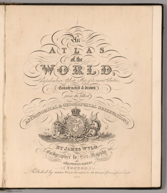
Wyld, James, 1812-1887
Full Title
(Title Page to) An Atlas of the World, Comprehending Separate Maps of its various Countries, Constructed & drawn from the latest Astronomical & Geographical Observations. By James Wyld, Geographer to Her Majesty and H. Late R.H. Prince Albert. London. Published by James Wyld (Successor to Mr. Faden) Charing Cross East. 1864.
Publisher
James Wyld
Author
Arrowsmith, Aaron Jr.
Full Title
(Title Page to) Outlines Of The World. By A. Arrowsmith, Hydrographer to His Majesty. 1825. London; Published Jany 4th 1825, by A. & S. Arrowsmith, No. 10, Soho Square. (title page portrait) Aaron Arrowsmith ... Obiit. 1823. H.W. Pickersgill A.R.A. Pinxt. T.A. Dean Sculpt.
Publisher
A. & S. Arrowsmith
|