Browse All

1932 Minnesota standard map. Pocket Map Rand McNally standard map of Minnesota . … |

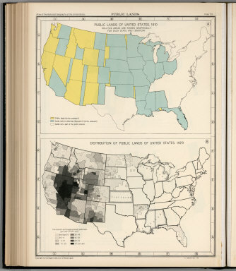
1932 Plate 57. Public Lands of United States, … [Historical Atlas, National Atlas] Plate 57. Public Lands. Public Lands of … |

1932 Plate 58. Public Lands of United States, … [Historical Atlas, National Atlas] Plate 58. Public Lands. Public Lands of … |
1932 Plate 59. Public Lands of United States, … [Historical Atlas, National Atlas] Plate 59. Public Lands. Public Lands of … |
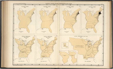
1932 Plate 61. Colonial Towns, States, Territ … [Historical Atlas, National Atlas] Plate 61. Colonial Towns, States, Territ … |

1932 Plate 62. States, Territories and Cities … [Historical Atlas, National Atlas] Plate 62. States, Territories and Cities … |

1932 Plate 63. States, Territories and Cities … [Historical Atlas, National Atlas] Plate 63. States, Territories and Cities … |

1932 Plate 64. States, Territories and Cities … [Historical Atlas, National Atlas] Plate 64. States, Territories and Cities … |

1932 Plate 65. States, Territories and Cities … [Historical Atlas, National Atlas] Plate 65. States, Territories and Cities … |

1932 Plate 66. States, Territories and Cities … [Historical Atlas, National Atlas] Plate 66. States, Territories and Cities … |

1932 Plate 67. States and Cities: Population, … [Historical Atlas, National Atlas] Plate 67. States and Cities: Population. … |