Browse All

1851 8. Idealer Durchschnitt der Erdrinde Physical Atlas 8. Idealer Durchschnitt der Erdrinde ... … |

1802 United States 1. Regional Atlas A map of the United States of North Amer … |

1850 Hauteur des montagnes. World Atlas Tableau comparatif de la forme et de la … |

1793 Plan and elevation of the Propylaea. No. … Classical Atlas Plan and elevation of the Propylaea. Fou … |

1793 Plan of the Temple of Theseus (with) Par … Classical Atlas Plan of the Temple of Theseus. No.1. (wi … |

1787 Essay on the Environs of Delphi. No. 16 Classical Atlas Essay on the Environs of Delphi, For the … |

1872 Camp Point, Illinois. (View) Residence o … County Atlas Map of Camp Point, Camp Point Township. … |

1872 Coatsburg. Houston. Paloma. Lima, Illino … County Atlas Map of Coatsburg. Map of Houston. Map of … |

1874 City of Goshen. (View) M.E. Church. Jno. … County Atlas City of Goshen. (View) M.E. Church. Jno. … |

1874 Town of Elkhart. (View) Dodges Drug; J.F … County Atlas Town of Elkhart. (View) Dodges Drug; J.F … |

1877 Santa Rosa and Sonoma Townships. (and) V … County Atlas Plat of Windsor (with) Plat of Town of F … |

1829 Turkey III. Southern Greece and Candia. World Atlas Turkey III. Containing the southern part … |

1865 Fortaleza de Sacsahuaman; Plano antiguo … National Atlas Plano de la Fortaleza de Sacsahuaman al … |

1865 Plano y vista de las Islas de Chincha. National Atlas Plano de las Islas de Chincha. Vista de … |

1876 Illinois in 1822 (with view:) First Stat … State Atlas Illinois in 1822. (with view:) First Sta … |

1876 Map of Clinton County, and view of resid … State Atlas Map of Clinton County. (with view:) Resi … |

1854 Bai San Francisco und Vereinigung des Sa … National Atlas Bai San Francisco und Vereinigung des Sa … |

1736 A general map of Turkey in Europe, Hunga … World Atlas A general map of Turky in Europe, Hungar … |

1736 Caspian Sea, Terky, Derbent, Astracan. World Atlas The Caspian Sea. Drawn by the Czar's Spe … |
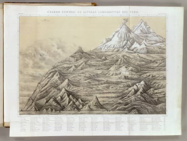
1865 Cuadro general de alturas comparativas d … National Atlas Cuadro general de alturas comparativas d … |

1865 Temblores en Arequipa; Cortes vertical, … National Atlas Linea que representa los temblores senti … |

1878 Map of Milwaukee County, State of Wiscon … State Atlas Map of Milwaukee County, State of Wiscon … |