Browse All

1844 Cranes Des Indiens Tetes Plates De La Co … Exploration Book Cranes Des Indiens Tetes Plates De La Co … |
1875 View: Hieroglyphic View of Maine School Atlas (View to) Maine. (to accompany) A Hierog … |

1875 View: Hieroglyphic View of New Hampshire School Atlas (View to) New Hampshire. (to accompany) … |

1875 View: Hieroglyphic View of Vermont School Atlas (View to) Vermont. (to accompany) A Hier … |

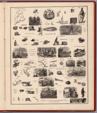
1875 View: Hieroglyphic View of Massachusetts School Atlas (View to) Massachusetts. (to accompany) … |

1875 View: Hieroglyphic View of Rhode Island School Atlas (View to) Rhode Island. (to accompany) A … |

1875 View: Hieroglyphic View of Connecticut School Atlas (View to) Connecticut. (to accompany) A … |

1875 View: Hieroglyphic View of New York School Atlas (View to) New York. (to accompany) A Hie … |

1875 View: Hieroglyphic View of New York (con … School Atlas (View to) New York (continued). (to acco … |

1799 Anchorage of the Vessels, at the Island … Exploration Book View of the Anchorage of the Vessels, at … |

1799 Views of the North West Coast of America … Exploration Book Views of the North West Coast of America … |

1799 Port des Francais for the Fishing Season … Exploration Book Establishment of the Inhabitants of the … |

1799 Black Bird of Port des Francais. Exploration Book Black Bird of Port des Francais. Publish … |

1799 Dress of the Inhabitants of Port des Fra … Exploration Book Dress of the Inhabitants of Port des Fra … |

1799 Woman of Port des Francais. Exploration Book A Woman of Port des Francais. Published … |

1799 Wreck of the Two Boats at Port des Franc … Exploration Book Wreck of the Two Boats at Port des Franc … |

1799 Views of the North West Coast of America … Exploration Book Views of the North West Coast of America … |

1799 Views of the North West Coast of America … Exploration Book Views of the North West Coast of America … |

1799 Bay of Monterey. Exploration Book Plan of the Bay of Monterey, Situate in … |

1799 Male & Female Partridge of California. Exploration Book Male & Female Partridge of California. P … |

1799 Promerops or Bee-Eater of California. Exploration Book Promerops or Bee-Eater of California. Pu … |

1825 Carte chronologique des Etats-Unis. National Atlas Carte chronologique des Etats-Unis, pres … |

1825 Tableau compare des constitutions des Et … National Atlas Tableau compare des constitutions des Et … |

1909 Presidents U.S., autographs, biographies … State Atlas The presidents of the United States. Aut … |

1909 (Presidents U.S., autographs, biographie … State Atlas (The presidents of the United States. Au … |

1909 (Presidents U.S., autographs, biographie … State Atlas (The presidents of the United States. Au … |

1824 Title Page: Atlas til Friherre Klinckows … National Atlas Title Page to: Atlas til Friherre Klinck … |

1807 Orme sous lequel Guillaume Penn. Historical Atlas Orme sous lequel Guillaume Penn, conclut … |

1878 View: Chief Mountain (Looking West) Exploration Book (View) Chief Mountain (Looking West) |

1878 View: The Milk River Gorge. Exploration Book (View) The Milk River Gorge. |

1878 View: Ojibway Camp, Lake of the Woods. Exploration Book (View) Ojibway Camp, Lake of the Woods. |

1878 View: Sioux Grave, Mouse River. Exploration Book (View) Sioux Grave, Mouse River. |

1878 View: Chief Mountain Lake (Looking South … Exploration Book (View) Chief Mountain Lake (Looking Sout … |

1878 View: Half Breed Hunters Camp (Near the … Exploration Book (View) Half Breed Hunters Camp (Near the … |

1878 View: La Roche Percee, Mouse River. Exploration Book (View) La Roche Percee, Mouse River. |

1878 View: Snow Storm in the Coteau, Sept. 22 … Exploration Book (View) Snow Storm in the Coteau, Sept. 2 … |

1878 View: Bad Lands, Frenchmans Creek. Exploration Book (View) Bad Lands, Frenchmans Creek. |

1878 View: Instrument Stand. Exploration Book (View) Instrument Stand. |

1878 View: Cutting Meridian North West Point, … Exploration Book (View) Cutting on Meridian North West Po … |

1878 View: Cameron's Fall, Chief Mountain Lak … Exploration Book (View) Cameron's Fall, Chief Mountain La … |

1878 View: Assinniboine Camp. Exploration Book (View) Assinniboine Camp. |

1878 View: Targets Used in Tracing Tangents d … Exploration Book (View) Targets Used in Tracing Tangents … |

1878 View: Pyramid Creek. Exploration Book (View) Pyramid Creek. |

1878 View: Rocky Mountain Falls, West of Chie … Exploration Book (View) Rocky Mountain Falls, West of Chi … |

1878 View: Camp at Pine Ridge, Dec 22d. 1873, … Exploration Book (View) Camp at Pine Ridge, Dec 22d. 1873 … |

1877 Pittsburg, Cincinnati and St. Louis R.R. … County Atlas Map of the Pittsburg, Cincinnati and St. … |

1895 (Uniforms, US, CS armies) Military Atlas (Uniforms, officers and enlisted men). ( … |

1895 (Ordnance, stores, etc.) Military Atlas (Ordnance, ordnance stores, etc.). Juliu … |

1895 (Care of sick, wounded) Military Atlas (Care of and means of transportation of … |

1895 (Flags, badges, etc.) Military Atlas (Corps flags, badges, etc.). Julius Bien … |