Who What Where WhenWHO
WHEN
|
Author
Smith, C.
Full Title
Comparative View of the Heights of the Principal Mountains &c. in the World. London, Published by C. Smith Mapseller, No.172 Strand, Augt. 1st. 1816. Gardner, Sculpt. (Third Edition)
Publisher
C. Smith
Author
C. Smith & Son
Full Title
A Comparative Picture of the Principal Waterfalls in the World. London. C. smith & Son. 172 Strand. 1836.
Publisher
C. Smith & Son
Author
Johnson, A.J.
Full Title
Johnson's Chart of Comparative Heights of Mountains, and Lengths of Rivers of Africa ... Asia ... Europe ...South America ... North America. 5. 6.
Publisher
A.J. Johnson.
Author
La Perouse, Jean-Francois de Galaup, comte de, 1741-1788
Full Title
View of the Island of St. Catherine. de Vancy delt. Published as the Act directs Novr. 1st 1798, by G.G. & J. Robinson, Pater-noster Row. de Vancy, delt. Heath Sculpt. No. 2.
Publisher
G.G. & J. Robinson.
Author
[Bourquin, Frederick, Mitchell, Samuel Augustus, Tanner, Henry S.]
Full Title
Lengths of the Principal Rivers of the World. Heights of the Principal Mountains of the World. 72.
Publisher
S. Augustus Mitchell.
Full Title
Carte des principales montagnes du globe. Hauteur comparative des principales montagnes du globe. Fonderie et Imprimerie de J. Carez. (1825)
Publisher
J. Carez
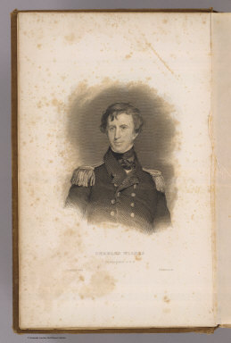
Author
Sully, Thomas
Full Title
Charles Wilkes, Commander U.S.N. Painted by T. Sully. R.W. Dodson sc. (Philadelphia: Lea & Blanchard. 1845)
Publisher
Lea & Blanchard
Author
Agate, A. T.
Full Title
Wm. L. Hudson, Commander U.S.N. (Drawn by) A.T. Agate. (Engraved by) Jordan & Halpin. (Philadelphia: Lea & Blanchard. 1845)
Publisher
Lea & Blanchard
Full Title
Table of the comparative heights of the principal mountains &c. in the World. (Written and engraved by Jos. Perkins. 1845)
Publisher
Tanner's Geographical Establishment
Author
[Dower, John Nicaragua, Teesdale, Henry]
Full Title
A Comparative View of the Heights of the Principal Mountains and Lengths of the Principal Rivers in the World. London: Published by Henry Teesdale & Co. Drawn & Engraved by J. Dower, Pentonville, London. (1844)
Publisher
Henry Teesdale & Co.
Author
[Brockhaus, F.A., Leeder, Ehrenfried, Leutemann, Heinrich]
Full Title
Planigloben.
Publisher
F.A. Brockhaus
Author
[Brockhaus, F.A., Leeder, Ehrenfried, Leutemann, Heinrich]
Full Title
Luft-und Meeresstromungen.
Publisher
F.A. Brockhaus
Author
Wyld, James, 1812-1887
Full Title
A Comparative View of the Superficies and Population of the Globe. J.W. del. Stockley, Sc. London, (published by) James Wyld. Charing Cross. (to accompany) An Atlas of the World, Comprehending Separate Maps of its various Countries, Constructed & drawn from the latest Astronomical & Geographical Observations. By James Wyld, Geographer to Her Majesty and H. Late R.H. Prince Albert. London. Published by James Wyld (Successor to Mr. Faden) Charing Cross East. 1864.
Publisher
James Wyld
Author
Mitchell, Samuel Augustus
Full Title
Lengths of the Principal Rivers in the World. Heights of the Principal Mountains in the World. F. Humphrys. Sculpt.
Publisher
S.A. Mitchell
Author
Mitchell, Samuel Augustus Jr.
Full Title
A time table indicating the difference in time between the principal cities of the World and also showing their air-line distance from Washington. Entered ... 1864 by S. Augustus Mitchell, Jr. ... Pennsylvania.
Publisher
S.A. Mitchell Jr.
Author
Lothian, John
Full Title
(View) Comparative View of the Principal Mountains and Rivers in the World.
Publisher
James MacLeod and Francis Orr & Sons
Author
[Gray, Frank A., Lathrop, J.M., Penny, H.C., Proctor, W.R.]
Full Title
Gray's New Map of the World in Hemispheres, with Comparative View of the Heights of the Principal Mountains and Lengths of the Principal Rivers on the Globe by Frank A. Gray.Western Hemisphere. Eastern Hemisphere. Time Diagram.
Publisher
D.J. Lake
Author
Cornell, S. S. (Sarah S.)
Full Title
The World, showing its great river systems. Designed to accompany Cornell's High school geography. (with Lengths of rivers, heights of mountains). Engraved by Geo. Rae Smith, N.Y.. Entered ... 1856, by S.S. Cornell ... Southern District of New York. New York: D. Appleton & Co., 443 & 445 Broadway. (1864)
Publisher
Appleton & Co.
Full Title
Appendix. General questions on geography; or a game ... A table of general questions after a method suggested by Lady Ch******e L*****r. Printed by S. & R. Bentley, Dorset Street, Fleet Street, London. (1821)
Publisher
Harris and Son
Author
Thomson, John
Full Title
A comparative view of the heights of the principal mountains and other elevations in the World. Drawn & engraved for Thomson's New general atlas by W. & D. Lizars, Edinburgh. (1817)
Publisher
[Baldwin, Cradock, and Joy, John Cumming, John Thomson]
Author
Mitchell, Samuel Augustus
Full Title
A time table indicating the difference in time between the principal cities of the world, and also showing their air-line distance from Washington. Entered according to Act of Congress in the year 1864 by S. Augustus Mitchell, Jr. in the ... District Court of the U.S. for the Eastern District of Pennsylvania. (1873)
Publisher
M.W. White
Author
Lizars, Daniel
Full Title
Table of mountain chains: together with the altitudes of their principal summits. (with view) Culminating points & mean height of the principal chains of mountains of Europe, America & Asia, with the lower limit of perpetual snow in different latitudes. (Published by D. Lizars, Edinburgh. 1831?)
Publisher
[John Hamilton, W. Curry, Jun. & Co., Whittaker, Treacher & Co.]
Author
Lizars, Daniel
Full Title
Table of mountain chains: together with the altitudes of their principal summits. (Published by D. Lizars, Edinburgh. 1831?)
Publisher
[John Hamilton, W. Curry, Jun. & Co., Whittaker, Treacher & Co.]
Full Title
A chart exhibiting the comparative size, population, form of government and number of square miles in each of the principal empires, kingdoms &c. of the globe, also the manner of building among the different nations according to their civilization. To accompany Olney's Geography. Entered according to act of Congress.
Publisher
Robinson, Pratt & Co.
Author
Mitchell, Samuel Augustus
Full Title
A time table indicating the difference in time between the principal cities of the World and also showing their air-line distance from Washington. Entered ... 1864 by S. Augustus Mitchell, Jr. ... Pennsylvania. (1890)
Publisher
John Y. Huber & Co.
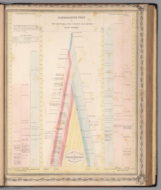
Full Title
Comparative lengths of the principal rivers throughout the World. Comparative view of mountains. (1829)
Publisher
Collins & Hannay
Author
Clouet, J. B. L. (Jean-Baptiste Louis), b. 1730
Full Title
Des vents. (1787)
Publisher
Mondhare et Jean
Full Title
Comparative heights of mountains. (Boston: Hilliard, Gray, Little and Wilkins, 1826)
Publisher
Hilliard, Gray, Little and Wilkins
Full Title
Comparative lengths of rivers. (Boston: Hilliard, Gray, Little and Wilkins, 1826)
Publisher
Hilliard, Gray, Little and Wilkins
Author
Mitchell, Samuel Augustus
Full Title
A time table indicating the difference in time between the principal cities of the World and also showing their air-line distance from Washington. Entered ... 1864 by S. Augustus Mitchell, Jr. ... Pennsylvania. (1880)
Publisher
S.A. Mitchell
Full Title
(La Sphere. A Lyon, Chez Jean-Marie Bruyset, Pere & Fils. M.DCC.LXXXIV)
Publisher
Jean-Marie Bruyset
Author
Fenner, Rest.
Full Title
A comparative view of the heights of the principal mountains and lengths of the principal rivers of the World. Fenner Sc., Paternoster Row. (London, Joseph Thomas, 1835)
Publisher
Joseph Thomas
Author
Mitchell, Samuel Augustus
Full Title
Lengths of the Principal Rivers in the World. Heights of the Principal Mountains in the World. Tinted illustration. 77. F. Humphreys, Sculpt. Entered according to Act of Congress in the year 1860 by Charles Desilver in the Clerk's office if the District Court of the Eastern District of Pennsylvania.
Publisher
Charles Desilver.
Author
Johnston, Alexander Keith, 1804-1871
Full Title
Comparative views of remarkable geological phenomena by A.K. Johnston, F.R.G.S. Engraved by W. & A.K. Johnston. William Blackwood & Sons, Edinburgh & London. (1856)
Publisher
William Blackwood & Sons
Author
[Henfrey, Arthur, 1819-1859, Johnston, Alexander Keith, 1804-1871, Schouw, Joakim Frederik, 1789-1852]
Full Title
Geographical distribution of indigenous vegetation. The distribution of plants in a perpendicular direction in the torrid, temperate and frigid zones, with indications of the mean temperature of the year and of the coldest and warmest months by A.K. Johnston, F.R.S.E. & Arthur Henfrey, F.R.S., E.L.S. &c. Map of Schouws phyto-geographic regions with the distribution of plants especially influencing the physiognomy of the vegetation of the globe. Engraved & printed in colours by W. & A.K. Johnston, Edinburgh. William Blackwood & Sons, Edinburgh & London. 1st. May 1854, (1856)
Publisher
William Blackwood & Sons
Author
Johnston, Alexander Keith, 1804-1871
Full Title
Zoological geography. Geographical division & distribution of Simiae & Prosimiae, monkeys & makis, from the latest authorities by A.K. Johnston, F.R.S.E. Geographical division & distribution of Pachydermata, thick skinned animals ... Engraved by W. & A.K. Johnston. William Blackwood & Sons, Edinburgh & London. (1856)
Publisher
William Blackwood & Sons
Author
Johnston, Alexander Keith, 1804-1871
Full Title
Zoological geography. Geographical division & distribution of Carnivora, carnivorous animals, from the latest authorities by A.K. Johnston, F.R.G.S. (with) District inhabited by the fur-bearing animals and theatre of the whale & seal fishery in the Northern Hemisphere. Engraved by W. & A.K. Johnston. William Blackwood & Sons, Edinburgh & London. (1856)
Publisher
William Blackwood & Sons
Author
[Johnston, Alexander Keith, 1804-1871, Waterhouse, G. R. (George Robert), 1810-1888]
Full Title
Zoological geography. Geographical division & distribution of Rodentia, gnawing animals, constructed from the tables & notes of Geo. R. Waterhouse, Esqr. by A.K. Johnston, F.R.G.S. Geographical division and distribution of Ruminantia, ruminating animals ... Engraved by W. & A.K. Johnston. William Blackwood & Sons, Edinburgh & London. (1856)
Publisher
William Blackwood & Sons
Author
Johnston, Alexander Keith, 1804-1871
Full Title
Zoological geography. Geographical division and distribution of the birds of Europe from the latest authorities by A.K. Johnston, F.R.G.S. Geographical division of Aves, birds, over the world. Engraved by W. & A.K. Johnston. William Blackwood & Sons, Edinburgh & London. (1856)
Publisher
William Blackwood & Sons
Author
[Johnston, Alexander Keith, 1804-1871, Schlegel, H. (Hermann), 1804-1884]
Full Title
Zoological geography. Geographical division and distribution of Reptilia, reptiles, by A.K. Johnston. (with) Geographical division and distribution of Ophidia, serpents, according to Schlegel. (with) Venomous serpents. Engraved by W. & A.K. Johnston. William Blackwood & Sons, Edinburgh & London. (1856)
Publisher
William Blackwood & Sons
Author
[Forbes, Edward, 1815-1854, Johnston, Alexander Keith, 1804-1871]
Full Title
Map of the distribution of marine life, illustrated chiefly by fishes, Molluscs & Radiata; showing also the extent & limits of the Homoiozoic belts, now first laid down for Keith Johnston's Physical atlas by Professor Edward Forbes, F.R.S., of Kings College, London & the Government School of Mines, President of the Geological Society. Engraved & printed in colours by W. & A.K. Johnston, Edinr. William Blackwood & Sons, Edinburgh & London. 1st March 1854, (1856)
Publisher
William Blackwood & Sons
Author
Bromme, Traugott
Full Title
8. Idealer Durchschnitt der Erdrinde ... Entworfen von Tr. Bromme. Ausgefuhrt v. E. Winckelmann. Stuttgart. Verlag von Krais & Hoffman. (to accompany) Atlas zur Physik der Welt. (with second title page) Atlas zu Alex. v. Humboldt's Kosmos ... Bromme. (with insets)
Publisher
Krais & Hoffman
Author
Bromme, Traugott
Full Title
35. Kosmisch meteorologische Landschaftsbilder. Entworfen von Tr. Bromme. Ausgefuhrt von F. Foltz.. Stuttgart. Verlag von Krais & Hoffman. (to accompany) Atlas zur Physik der Welt. (with second title page) Atlas zu Alex. v. Humboldt's Kosmos ... Bromme.
Publisher
Krais & Hoffman
Author
Bromme, Traugott
Full Title
36. Geologische Landschaftsbilder. Entworfen von Tr. Bromme. Ausgefuhrt von E. Hofer. Stuttgart. Verlag von Krais & Hoffman. (to accompany) Atlas zur Physik der Welt. (with second title page) Atlas zu Alex. v. Humboldt's Kosmos ... Bromme.
Publisher
Krais & Hoffman
Author
Bromme, Traugott
Full Title
37. Charakter-Landschaften. Entworfen von Tr. Bromme. Ausgefuhrt von A. Fesca. Stuttgart. Verlag von Krais & Hoffman. (to accompany) Atlas zur Physik der Welt. (with second title page) Atlas zu Alex. v. Humboldt's Kosmos ... Bromme.
Publisher
Krais & Hoffman
Author
[Cook, James, 1728-1779, Furneaux, Tobias, 1735-1781, Hodges, William, 1744-1797]
Full Title
(Title Page to) A voyage towards the South Pole, and round the World. Performed in His Majesty's ships the Resolution and Adventure, in the years 1772, 1773, 1774, and 1775. Written by James Cook, Commander of the Resolution ... In two volumes illustrated with maps and charts ... The second edition. (with portrait) Captain James Cook, F.R.S. Painted by Wm. Hodges. Engraved by J. Basire, 1777. London: Printed for W. Strahan; and T. Cadell in the Strand. MDCCLXXVII.
Publisher
W. Strahan and T. Cadell
Author
[Andriveau-Goujon, J., Bruguiere, Louis]
Full Title
Tableau comparatif de la forme et de la hauteur des principales montagnes du globe terrestre, dedie a Monsieur le Baron, Alexdre. de Humboldt. A Paris, chez J. Andriveau-Goujon, Rue du Bac, no. 17. Par son tres humble et tres obeissant serviteur Louis Bruguiere. Grave par Ambroise Tardieu. (1850)
Publisher
J. Andriveau-Goujon
Author
Andriveau-Goujon, J.
Full Title
Pavillons et cocardes des principales puissances du globe d'apres des documens officiels. Publie a Paris par J. Andriveau-Goujon, Rue du Bac, no. 21, 1850.
Publisher
J. Andriveau-Goujon
Author
Bradford, Thomas G.
Full Title
Comparative heights of mountains. (to accompany) A Comprehensive Atlas, Geographical, Historical & Commercial. By T.G. Bradford. William D. Ticknor, Boston. Wiley & Long, New-York. Entered ... 1835, by Thos. G. Bradford ... Massachusetts.
Publisher
[William D. Ticknor, Wiley & Long]
Author
Bradford, Thomas G.
Full Title
Comparative lengths of rivers. (inset) Distribution of vegetables, and snow line. (to accompany) A Comprehensive Atlas, Geographical, Historical & Commercial. By T.G. Bradford. William D. Ticknor, Boston. Wiley & Long, New-York. Entered ... 1835, by Thos. G. Bradford ... Massachusetts.
Publisher
[William D. Ticknor, Wiley & Long]
|