Who What Where WhenREMOVE |
REFINE
Browse All : Wall Map of California
1-39 of 39
Author
Higley, Horace A.
Full Title
Official Map Of The County Of Alameda California Surveyed and compiled by Order of the Board of Supervisors. Horace A. Higley, County Surveyor. April - 1857. Lithy. of Britton & Rey, S.F.
Publisher
Britton & Rey
Author
Goddard, George H. (George Henry), 1817-1906
Full Title
Britton & Rey's Map Of The State Of California. Compiled from the U.S. Land & Coast Surveys, the several Military, Scientific & Rail Road Explorations, the State & County Boundary Surveys made under the Order of the Surveyor General of California, & from Private Surveys. By George H. Goddard, C.E. Completed with Additions & Corrections up to the day of publication from the U.S. Land Office & other reliable sources. Lithy. Of Britton & Rey, Montgomery St. Cor. Commercial, S.F. Entered ... 1857 by Britton & Rey ... California. Engraved by H. Steinegger.
Publisher
Britton & Rey
Author
Kenyon Company
Full Title
Map Of California And Western Nevada. For Latest Census See Back of Map ... Copyrighted, Engraved And Published By The Kenyon Company, Inc., Map Makers, Des Moines, Iowa ... (with 4 inset maps).
Publisher
The Kenyon Company, Inc., Map and Calendar Makers
Author
[Arnold, T. J. (Thomas Jefferson), d. 1878, California. Board of State Harbor Commissioners for San Francisco Harbor]
Full Title
Map exhibiting the salt marsh, tide and submerged lands disposed of by the State of California in and adjacent to the bays of San Francisco and San Pablo and now subject to reclamation. Prepared from maps of the U.S. Coast Survey & official records by order of the Board of State Harbor Commissioners for the United States Commissioners on San Francisco Harbor. By T.J. Arnold, engineer of the sea wall. 1874. U.S. Commissioners Rear Admiral John Rodgers, Major G.H. Mendell, Prof. George Davidson. State Harbor Commissioners Samuel Soule, T.D. Mathewson, D.C. McRuer. Britton Rey & Co. Lith. S.F.
Publisher
Britton & Rey
Author
Chevalier, August
Full Title
The "Chevalier" Commercial, Pictorial and Tourist Map of San Francisco From Latest U.S. Gov. and Official Surveys. Designed-Engraved And Copyrighted By Aug. Chevalier, Lithographer Publisher, San Francisco ... copyrighted 1911 ...
Publisher
Aug. Chevalier
Author
Sedelmeyer, H.A.
Full Title
Relief Map of California.
Publisher
H.A. Sedelmeyer
Author
[Jennings, Charles W., California Division of Mines and Geology]
Full Title
Fault Map of California , w/ locations of Volcanoes, Thermal Springs, and Thermal Wells.
Publisher
Williams & Heintz Map Corp
Author
Thomas Bros. Maps
Full Title
State of California.
Publisher
Thomas Bros. Maps
Author
United States Bureau of Reclamation, Region II
Full Title
Central Valley Project California, Three Stages of Development.
Publisher
United States Bureau of Reclamation
Author
Department of Geography, University of California at Berkeley
Full Title
Average Annual Precipitation.
Publisher
Manuscript
Author
Anonymous
Full Title
(California -- Physical)
Author
[Jennings, Charles W., Strand, R.G., Rogers, T.H.]
Full Title
Geologic Map of California.
Publisher
Charles W. Jennings
Author
[Western Water Resources Foundation, The Smith Brothers]
Full Title
California Water Resources Development.
Publisher
Western Water Resources Foundation
Author
Muermann, H.
Full Title
California, Nevada.
Publisher
Geo - Insttut
Author
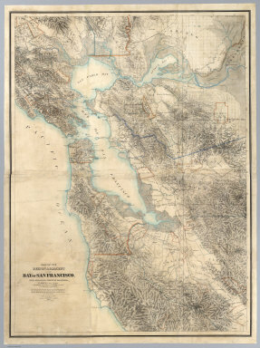
[Hoffmann, Charles F., Whitney, J.D., Geological Survey of California]
Full Title
Map Of The Region Adjacent To The Bay Of San Francisco. State Geological Survey Of California, J.D. Whitney, State Geologist. W. H. Brewer, W. M. Gabb, and A. Rémond, Assistants. C.F. Hoffman, Topographer. The Coast, Rancho, Township and Section Lines from Materials furnished by the U.S. Coast Survey and the U.S. Surveyor General's Office, the Topography chiefly from Original Surveys by C.F. Hoffman ... 1867. Engraved by Julius Bien, N.Y.
Publisher
Julius Bien
Author
Fairbanks, Harold W.
Full Title
Natural Environment Physical Political Map California.
Publisher
A.J. Nystrom & Co.
Author
Bagley, H.N.
Full Title
Culture Areas of the Indians of California, Showing also the tribes or local divisions.
Publisher
Bagley
Author
[State of California: The Resources Agency, Department of Water Resources]
Full Title
Surface Water Resources Development in California.
Publisher
California Department of Water Resources
Author
Weber, C.F.
Full Title
Weber's Township And County Map Of California, Nevada And Southern Oregon. Compiled & Drawn from the latest Data 1907. Published by C.F. Weber & Co. New Era Building, Corner Of Sutter And Polk Sts. San Francisco, Ca. 210 N. Main St. Los Angeles, Cal. Copyright, 1907, By C.F. Weber & Co. (inset) Map Of San Francisco And Adjacent Territory. (inset) Map Of Los Angeles And Adjacent Territory.
Publisher
C.F. Weber & Co.
Author
[Gibbes, C.D., Holt, Warren]
Full Title
Map of the States of California and Nevada. Carefully Compiled from the Latest Authentic Sources. California by Julius H. Von Schmidt, Arthur W. Keddie, and C.D. Gibbes, C.E.'s. Nevada by Chas. Drayton Gibbes C.E. Comprising Information obtained from the U.S. Coast and Land Surveys; State Geological Surveys, By Prof. J.D. Whitney; Railroad Surveys And The Results of Explorations Made By Brevet Lieut. Col. R.S. Williamson, U.S.A., Henry DeGroot, C.D. Gibbes, And Others. Entered ... 1876 by Warren Holt ... California.
Publisher
Warren Holt
Author
[Native Sons of the Golden West, London, M.C., Cahill, B.J.S.]
Full Title
(California) Eureka. Native Sons of the Golden West. Founded July 11, 1875 by General A.M. Winn, San Francisco, California. Copyright by M.C. London and B.J.S. Cahill. 1920.
Publisher
No. publisher
Author
[Hoffman, Hoffmann, Charles F., J.T. Gardner, Whitney, J.D., Geological Survey of California]
Full Title
Geological Survey Of California, J.D. Whitney, State Geologist. Map of a portion of the Sierra Nevada adjacent to the Yosemite Valley from surveys made by Chs. F. Hoffmann and J.T. Gardner, 1863-1867.Map of a portion of the Sierra Nevada adjacent to the Yosemite Valley.
Publisher
No Publisher
Author
Rand McNally and Company
Full Title
The Rand-McNally New County and Railroad Map Of California And Nevada. Copyright, 1912, Rand, McNally & Co. Chicago ... (with 5 inset maps).
Publisher
Rand McNally & Co.
Author
[Gibbes, C.D., Holt, Warren]
Full Title
Map of the States of California and Nevada. Carefully Compiled from the Latest Authentic Sources. California by Julius H. Von Schmidt, Arthur W. Keddie, and C.D. Gibbes, C.E.'s. Nevada by Chas. Drayton Gibbes C.E. Comprising Information obtained from the U.S. Coast and Land Surveys; State Geological Surveys, By Prof. J.D. Whitney; Railroad Surveys And The Results of Explorations Made By Brevet Lieut. Col. R.S. Williamson, U.S.A., Henry DeGroot, C.D. Gibbes, And Others. Entered ... 1868 by Warren Holt ... California.
Publisher
Warren Holt
Author
Bancroft, A.L.
Full Title
Bancroft's Map Of California, Nevada, Utah And Arizona. Published By A.L. Bancroft & Compy. Booksellers & Stationers, San Francisco, Cal. 1873. Entered ... by A.L. Bancroft & Company ... Washington, D.C.
Publisher
A.L. Bancroft
Author
Baker, P.Y.
Full Title
Map Of Tulare County California Compiled from actual Surveys by P.Y. Baker C.E. 1876. G.W. Terry, Map Colorer & Mounter, Rice's Building, 79 Dearborn St., Chicago, Ill. Approved and declared to be the Official Map of Tulare County by resolution of the Board of Supervisors, August, 1876. W.C. Owen, E.H. Baker, James Barton, Board of Supervisors. (with 4 inset maps).
Publisher
No Publisher
Author
[Gibbes, C.D., Holt, Warren]
Full Title
Map of the States Of California And Nevada. Carefully Compiled from the Latest Authentic Sources. California By Julius H. Von Schmidt, Arthur W. Keddie, And C.D. Gibbes, C.E.'s. Nevada By Chas. Drayton Gibbes C.E. S.B. Linton Engr. & Lithogr. 148-1/2 S. 4th Street, Philadelphia. Comprising Information obtained from the U.S. Coast And Land Surveys; State Geological Surveys, By Prof. J.D. Whitney; Railroad Surveys And The Results Of Explorations Made By Brevet Lieut. Col. R.S. Williamson, U.S.A., Henry DeGroot, C.D. Gibbes, And Others. Published by Warren Holt. No. 411 Kearny Street, San Francisco, Cal. 1869. Entered ... 1868, by Warren Holt ... California. (with 1 inset).
Publisher
Warren Holt
Author
Proctor, A.G.
Full Title
Official Map of Yolo County California Compiled from Official Records by A.G. Proctor, County Surveyor, 1926.
Publisher
A.G.Proctor
Author
Ashley, P.N.
Full Title
Official Map of the County of Yolo, California, Showing Roads, Railroads - Voting Precincts, School and Road Districts, Government Surveys and Private Ownership. Compiled and Pulished by P.N. Ashley, County Surveyor, Yolo County, 1900. Copyrighted by P.N. Ashley, 1900.
Publisher
P.N. Ashley
Author
Ashley, P.N.
Full Title
Official Map of the County of Yolo, California, Showing Roads, Railroads, Voting Precincts, School and Road Districts, Government Surveys and Private Ownership. Compiled and Pulished by P.N. Ashley, County Surveyor, Yolo County, 1908. Copyrighted by P.N. Ashley, February 1909.
Publisher
P.N. Ashley
Author
Miller, H.C.
Full Title
Official Map of Yolo County, California, Compiled and Pulished by H.C. Miller. 1891. Price $10.00.
Publisher
H.C. Miller
Author
[Dingle, C.O., Proctor, A.G.]
Full Title
Official Map of Yolo County, California, Compiled from Official Records by A.G. Proctor, County Surveyor and C.O. Dingle, Licensed Surveyor and Draftsman, 1915.
Publisher
A.G. Proctor
Author
Henning, J.S.
Full Title
Map of Yolo County, California, Compiled from Official and Recent Surveys by J.S. Henning, Surveyor and Engineer, May, 1871. Official Map.
Publisher
J.S. Henning
Author
Stitt, C.C.
Full Title
Official Map of Yolo County, California. Compiled from Official Records by C.C. Stitt, County Surveyor, 1939.
Publisher
C.C. Stitt
Author
Mitchell, Samuel Augustus
Full Title
A New Map of The States Of Texas & California, The Territories Of Oregon, New Mexico, Utah and the Regions adjacent. Compiled from the most recent authorities. Philadelphia: Published by S. Augustus Mitchell. 1852. Entered ... 1850, by Thomas, Cowperthwait & Co. ... Pennsylvania. (on verso) A New Map of Texas Oregon And California With The Regions Adjoining. Compiled from the most recent authorities. Philadelphia, Published by S. Augustus Mitchell, N.E. Corner Of Market & Seventh Streets. 1846. Entered ... 1845, by H.N. Burroughs ... Pennsylvania.
Publisher
S. Augustus Mitchell
Author
Mitchell, Samuel Augustus
Full Title
A New Map of Texas Oregon And California With The Regions Adjoining. Compiled from the most recent authorities. Philadelphia, Published by S. Augustus Mitchell, N.E. Corner Of Market & Seventh Streets. 1846. Entered ... 1845, by H.N. Burroughs ... Pennsylvania. (on verso) A New Map of The States Of Texas & California, The Territories Of Oregon, New Mexico, Utah and the Regions adjacent. Compiled from the most recent authorities. Philadelphia: Published by S. Augustus Mitchell. 1852. Entered ... 1850, by Thomas, Cowperthwait & Co. ... Pennsylvania.
Publisher
S. Augustus Mitchell
Author
Mitchell, Samuel Augustus
Full Title
A New Map of Texas Oregon and California With The Regions Adjoining. Compiled from the most recent authorities. Philadelphia Published by S. Augustus Mitchell N.E. Corner Of Market & Seventh Streets. 1846. Entered ... 1845 by H.N. Burroughs ... Pennsylvania.
Publisher
S. Augustus Mitchell
Author
Lecount, Josiah J.
Full Title
Official Map Of The City Of San Francisco, California. Published by Josiah J. Lecount, Manufacturer & Importer Of Stationery & Miscellaneous Books, Montgomery St., San Francisco. Approved By Geo. R. Turner, City & County Surveyor, 1859. Lithy. Of Britton & Co. S.F.
Publisher
Josiah J. Lecount
Author
Kenyon Company
Full Title
Index to California With Latest Official Census, Shipping, And Postal Guide. (with Inset map) Kenyon's United States Federal Highway Map. (on verso) Map Of California And Western Nevada. For Latest Census See Back of Map ... Copyrighted, Engraved And Published By The Kenyon Company, Inc., Map Makers, Des Moines, Iowa ... (with 4 inset maps).
Publisher
The Kenyon Company, Inc., Map and Calendar Makers
1-39 of 39
|