Who What Where WhenREMOVEWHAT
|
Author
Ensigns & Thayer
Full Title
Ornamental Map Of The United States & Mexico. Map Of The United States And Mexico. Published by Ensign, Thayer & Co., 50 Ann St., New York, And 127 Main St., Buffalo. Entered ... 1848, by Ensigns & Thayer ... New York. Sowle & Ward, 43 Cornhill, Boston.
Publisher
Ensign, Thayer & Co.
Author
Raisz, Erwin
Full Title
Landforms of the United States, to accompany Atwood's Physiographic Provinces of the United States.
Publisher
Edwin Raisz
Author
Klett-Perthes
Full Title
The United States of America. (Side 1).
Publisher
Justus Perthes Verlag Gotha GmBH
Author
Klett-Perthes
Full Title
The United States of America. (Side 2).
Publisher
Justus Perthes Verlag Gotha GmBH
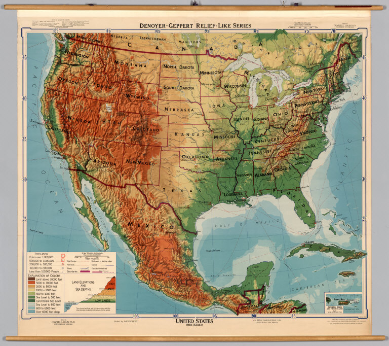
Author
[Colby, Charles C., Wenschow]
Full Title
United States with Mexico.
Publisher
Denoyer-Geppert Company
Author
Haack, Hermann
Full Title
Vereinigte Staaten und Mittleamerika.
Publisher
Justus Perthes
Author
U.S. General Land Office
Full Title
Department Of The Interior, General Land Office, Fred Dennett, Commissioner. United States Including Territories and Insular Possessions Showing the Extent of Public Surveys. Indian, Military And Forest Reservations, Railroads, Canals, National Parks And Other Details. Compiled Under The Direction Of L.P. Berthrong, Chief Of Drafting Division. 1913. M. Hendges, Draughtsman. The Sackett & Wilhelms Co.: New York. Engraved By R.F. Bartle & Co. Washington, D.C. (with) twelve inset maps listed in Notes.
Publisher
The Sackett & Wilhelms Co.
Author
Haack-Painke
Full Title
United States/Vereinigte Staaten.
Publisher
Justus Perthes
Author
Klett-Perthes
Full Title
United States of America.
Publisher
Justus Perthes Verlag Gotha GmbH
Author
Denoyer-Geppert Company
Full Title
Sectional Map of the United States, Southwestern/Northwestern United States.
Publisher
Denoyer-Geppert Company
Author
Lobeck, A.K.
Full Title
A Phsiographic Diagram of the United States, (Provisional Edition).
Publisher
A.J. Nystrom & Co.
Author
[United States Geological Survey (USGS), Bayer, Kenneth C.]
Full Title
Generalized Structural Lithographic and Physiographic Provinces in the Fold and Thrust Belts of the United States, (exclusive of Alaska and Hawaii).
Publisher
United States Geological Survey (USGS)
Author
The Geological Society of America
Full Title
Pleistocene Eolian Deposits of the United States, Alaska and parts of Canada.
Publisher
The Geological Society of America
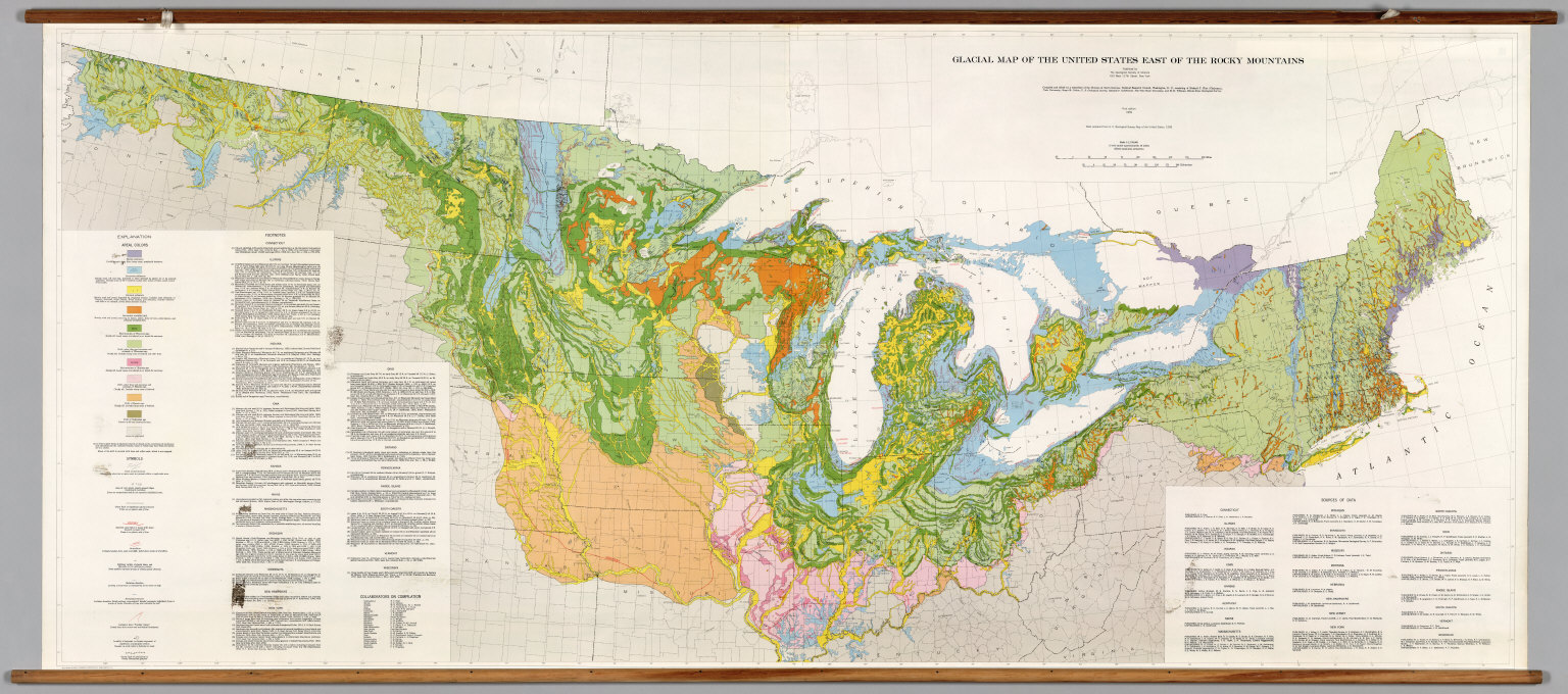
Author
[The Geological Society of America, Flint, Richard F.]
Full Title
Glacial Map of the United States East of the Rocky Mountains.
Publisher
The Geological Society of America
Author
[National Geographic Society, Garver Jr., John B., Garrett, Wilbur E.]
Full Title
The United States.
Publisher
National Geographic Society
Author
Mitchell, Samuel Augustus
Full Title
Mitchell's National Map of the American Republic Or United States Of North America. Together with Maps of the Vicinities Of Thirty-Two Of The Principal Cities And Towns in the Union. Published by S. Augustus Mitchell Philadelphia. 1845. No. 8-1/2 South Seventh Street. Drawn by J.H. Young. Engraved by J.H. Brightly. Entered ... 1842, by S. Augustus Mitchell ... Pennsylvania. (inset) Map Of the Southern Part Of Florida. (inset) Map Of The North-Eastern Boundary Of The United States ... (bordered by 32 additional inset maps).
Publisher
S. Augustus Mitchell
Author
U.S. General Land Office
Full Title
Map of the United States and territories, with adjacent parts of Canada and Mexico also part of the West India islands, showing the extent of public surveys, Indian, military, and forest reservations, rail roads, canals, national parks and other details, compiled from official surveys of the General Land Office and other authentic sources. Under the direction of the Hon. Lewis A. Groff, Commissioner. A.F. Dinsmore, Chief, Draughting Division. 1890. Isaac Friedenwald, Photo. Litho. Balto. Md. (inset) Territory of Alaska.
Publisher
Isaac Friedenwald Photo Litho.
Author
[Huntington, Eleazer, Willard, A.]
Full Title
Map of The United States Compiled from the most Authentic Sources. Published By E. Huntington & A. Willard, Hartford, 1826. Entered ... September, 1826. (with 5 inset maps).
Publisher
Huntington & Willard
Author
Willard, Emma
Full Title
Willard's Chronographer of American History. History of the U. States or Republic of America. Historic Tree.
Publisher
A.S. Barnes & Co.
Author
[Laurence, Dorthea Dix (1899-1979), Cimino, Harry (1898-]
Full Title
Folklore Music Map of the United States by Dorthea Dix Laurence from the Primer of American Music.
Publisher
Hagstrom Company, Inc.
Author
Geographical Publishing Company
Full Title
Excelsior Series Map of United States and Alaska.
Publisher
Geographical Publishing Company
Author
[Mitchell, Samuel Augustus, Young, James H.]
Full Title
Mitchell's Reference & Distance Map of the United States by J.H. Young. Published by S. Augustus Mitchell. Philadelphia: For Sale By S. Augustus Mitchell N.E. corner of Market & Seventh Streets; 1846. Engraved by P.H. Young, F. Dankworth, E. Yeager & E.F. Woodward. Entered ... 1833 by S. Augustus Mitchell ... Pennsylvania. (with) A New Map Of Texas Oregon And California With The Regions Adjoining ... Published by S. Augustus Mitchell ... 1846. (with) 7 inset maps.
Publisher
S.A. Mitchell
Author
[Johnson, A.J., Johnson, D. Griffing]
Full Title
A New Map Of The Union, With The Adjacent Islands & Countries, From Authentic Sources. Published by D.G. & A.J. Johnson, Trinity Buildings, 111 Broadway, New-York. 1857 ... Entered ... 1856 by D.G. Johnson ... New York. (inset of northwest Missouri and adjacent parts of Kansas and Nebraska).
Publisher
D.G. & A.J. Johnson
Author
[Chapin, William, Taylor, J.B.]
Full Title
Chapin's Ornamental Map Of The United States With Plans Of The World, British Possessions, West Indies & Columbia. New York, Published by W. Chapin & J.B. Taylor. 1846. Entered ... 1838 by W. Chapin & J.B. Taylor ... New York. Sold by T. & E.H. Ensign, No. 36 Ann St. N. York. Geographical Part Engraved By J.B. Taylor & H.F. Wheeler. Printed by Wm. Neale, N.Y. (above title) Steel Plates. (title engraving) Chapin del. Prudhomme sc. (portraits) Drawn & Engraved by Story & Atwood, N. York ... Painted by G. Stuart ... A. Dick sc. ... W.D. Smith sc. ... J.F.E. Prudhomme sc. Osborne sc. (with 9 inset maps).
Publisher
Chapin & Taylor.
Author
[Smith, J. Calvin, Smith, Robert P.]
Full Title
The New Naval And Military Map Of The United States. By J. Calvin Smith, Author Of Harper's Gazetteer, Colton's County Map Of The U.S. Travellers' Guide &c. 1862. J. Baker & Co. Publishers. J.M. Atwood, Map Engraver 517 Minor St. Philadelphia, Pa. Entered ... 1862 by Robert P. Smith ... Pennsylvania. (with 5 inset maps and 3 profiles).
Publisher
J. Baker
Author
Munson, S. Bishop
Full Title
A New And Embellished Map of the United States Compiled From the Latest & Most Authentic Documents, By S. Bishop Munson. 1845. Published By Doolittle & Munson & Sherer, Cincinnati, O. Corner of Main & Fifth Sts., opposite the Dennison House. Engraved By Doolittle & Munson. Entered ... 1843, by S. Bishop Munson ... Ohio. (inset) South Part of Florida. (inset of Oregon).
Publisher
Doolittle, Munson & Sherer
Author
[Smith, Robert P., Taintor, S. & Co.]
Full Title
The Washington Map of the United States By the Superintendent U.S. National Observatory, Washington D.C. 1862. S. Taintor & Co. 517, 519 & 521 Minor St. Philadelphia. Publishers. Holmes, Harrison & Co. London. Entered ... 1861 by Robert P. Smith ... Pennsylvania. (with) Five inset maps: The World and four thematic maps of the US showing Plants and Trees, Zoological Distribution, Temperature and Rainfall, and Geology.
Publisher
S. Taintor & Co
Author
[Smith, Robert P., Taintor, S. & Co.]
Full Title
The Washington Map Of The United States. By the Superintendent U.S. National Observatory, Washington D.C. 1862. S. Taintor & Co. Rochester, New York & Philadelphia, Pa. Publishers. Holmes, Harrison & Co. London. Entered ... 1861 by Robert P. Smith ... Pennsylvania. Printed by T.S. Wagner, 38 Hudson St. Phila. (with 6 inset maps and 3 profiles).
Publisher
S. Taintor & Co
Author
Chapin, William
Full Title
Chapin's Ornamental Map Of The United States With The New Western Possessions. New York, Published by Horace Thayer & Co. 1853. Entered ... 1851 by William Chapin ... New York. (above title) Steel Plates. (with 4 inset maps).
Publisher
Horace Thayer & Co.
Author
[Smith, Robert P., Taintor, S. & Co.]
Full Title
The Washington Map Of The United States. By the Superintendent U.S. National Observatory, Washington D.C. 1861. S. Taintor & Co. Publisher, W.H. Holmes, Engraver. 334 Pennsylvania Ave. Washington D.C. F. Mahler, C.E. Head Draughtsman. Entered ... 1861 by Robert P. Smith ... Pennsylvania. (with 6 inset maps and 3 profiles).
Publisher
S. Taintor & Co
Author
Mitchell, Samuel Augustus
Full Title
Mitchell's National Map of the American Republic Or United States Of North America. Together with Maps of the Vicinities Of Thirty-Two Of The Principal Cities And Towns in the Union. Published by S. Augustus Mitchell Philadelphia. 1843. No. 8-1/2 South Seventh Street. Drawn by J.H. Young. Engraved by J.H. Brightly. Entered ... 1842, by S. Augustus Mitchell ... Pennsylvania. (inset) Map Of the Southern Part Of Florida. (inset) Map Of The North-Eastern Boundary Of The United States ... (bordered by 32 additional inset vicinity maps of cities).
Publisher
S. Augustus Mitchell
Author
American Telephone and Telegraph Company
Full Title
Lines Of The Bell Telephone Companies. United States And Canada. July 1, 1909 ... W.H.C. American Telephone & Telegraph Co. And Associated Companies. Local And Long Distance Telephone Bell System. Heliotype Co. Boston. Copyright 1910 By The American Telephone And Telegraph Company. (top of map) Bell Telephone System.
Publisher
Heliotype Co.
Author
Watson, Gaylord
Full Title
Watson's New County And Railroad Map Of The United States And Of The Dominion Of Canada. Compiled From The Latest Official Sources. 1874. Entered ... 1872, by Gaylord Watson ... Washington. (with 5 inset maps). (On verso) Watson's County And Railroad Map Of The Western States And Territories 1874. Watson's Western Map Depot, 64 Lake Street ... Chicago, Ills. R.A. Tenney, Manager. Entered ... 1871, by Gaylord Watson ... Washington ... (and) Map Of Norway, Sweden And Germany ...
Publisher
Gaylord Watson
Author
Watson, Gaylord
Full Title
Watson's County And Railroad Map Of The Western States And Territories 1874. Watson's Western Map Depot, 64 Lake Street ... Chicago, Ills. R.A. Tenney, Manager. Entered ... 1871, by Gaylord Watson ... Washington ... (and) Map Of Norway, Sweden And Germany ... (On verso) Watson's New County And Railroad Map Of The United States And Of The Dominion Of Canada. Compiled From The Latest Official Sources. 1874. Entered ... 1872, by Gaylord Watson ... Washington. (with 5 inset maps).
Publisher
Gaylord Watson
Author
Robinson, Lewis
Full Title
Map of the United States. Compiled From The Latest Authorities. Published By Lewis Robinson. Reading Vt. 1833. Engraved by J.G. Darby.
Publisher
Lewis Robinson
Author
Monk, Jacob
Full Title
Monk's Standard American Map Exhibiting the larger portion of North America; Embracing The United States And Territories, Mexico, And Central America, Including The West India Islands, The Canadas, New Brunswick And Nova Scotia. Compiled from recent Government surveys and other authentic sources. Baltimore. Drawn, Engraved & Printed by A. Hoen & Co. Second street. Published by Jacob Monk. 1859. (inset) New Map Of The World on Mercators Projection ...
Publisher
Jacob Monk
Author
Woodbridge, J.L.
Full Title
Map of the United States With The Recent Counties, Cities, Villages and Internal Improvements in the Western States. By J.L. Woodbridge. Geographer And Topographical Engineer N. York, Published By Phelps & Ensign. 1845. (with 4 inset maps) North Part Of Maine. Map of North America including the West Indies. South Part Of Florida. Texas. (with) diagram showing Comparative Heights of the Principal Mountains in the U. States. (with) Physical Sections from "Washington City to Wheeling and from thence to the mouth of Columbia river" and from the "Pacific Ocean to the Gulf of Mexico."
Publisher
Phelps & Ensign
Author
Lewis, Samuel
Full Title
A New and correct Map of The United States Of North America; Exhibiting The Counties, Towns, Roads &c. in each State. Carefully compiled from Surveys and the most Authentic Documents, By Samuel Lewis. W. & S. Harrison sculpt. Philadelphia, Published by Emmor Kimber 1816. Copy Right secured according to Law.
Publisher
Emmor Kimber
Author
Thrall, Willis
Full Title
Map of the United States Compiled from the most Authentic Sources. Published By Willis Thrall, Hartford, 1831. (with four inset maps).
Publisher
Willis Thrall
Author
[Gaston, Samuel N., Morse, Charles W.]
Full Title
A New Map Of Our Country Present And Prospective. Compiled from Government Surveys and other Reliable Sources. Published by J.G. Wells, New York. Mack R. Barnitz, Cincinnati, Ohio. 1859. Entered ... 1856 by Morse & Gaston ... New York. (inset) Map Of The World On Mercators Projection By Milo Doty. 1858.
Publisher
J.G. Wells
Author
[Gaston, Samuel N., Morse, Charles W.]
Full Title
A New Map of Our Country, Present & Prospective. Compiled from Government Surveys and other Reliable Sources. Published by Morse & Gaston, 115 & 117 Nassau Street, New York, 1856. (with) three inset maps: New York; Vicinity of New York; Map of the World on Mercators Projection by S.N. Gaston, 1856.
Publisher
Morse & Gaston
Author
[Colton, J. H., Smith, J. Calvin]
Full Title
Colton's Map Of The United States Of America Including Canada and a large portion of Texas: Showing the Base Meridian and Township Lines of the U.S. Surveys, The lands allotted to the Indian Tribes west of the Mississippi, The Various Internal Improvements &c. Compiled from surveys of the United States Land Office, and various other authentic sources. By J. Calvin Smith. New York, Published by J.H. Colton, 86 Cedar Street. 1854. Revised Edition. Steel Plate. Entered ... 1843 by Geo. E. Sherman & J. Calvin Smith ... New York. Engraved and Printed by Sherman & Smith, New York ... (inset) Map Of North America By J. Calvin Smith. (inset) Southern Part Of Florida.
Publisher
J.H. Colton
Author
Lay, Amos
Full Title
Lay's Map of the United States. Compiled from the Latest and best Authorities and Actual Surveys By Amos Lay, Geographer and Map Publisher New York 1832. Engraved by O.H. & D.L. Throop & Wm. Chapin, New York. O.H. Throop, del. Entered ... May 8th 1827 By Amos Lay ... New York. (inset) Florida.
Publisher
Amos Lay
Author
[Atwood, J.M., Ensigns & Thayer]
Full Title
Pictorial Map Of The United States. 1847. Published By Ensigns & Thayer, 36 Ann Street, New York. Drawn & Engraved by J.M. Atwood, New York. Entered ... 1847, by Phelps, Ensign's & Thayer ... New York. Printed by Miller & Boyle, No. 102 Broadway, N.Y. (inset) Map Of Mexico.
Publisher
Ensigns & Thayer
Author
Varle, Charles P.
Full Title
Map of the United States By Chas. Varle, Engineer and Geographer. New York, 1832. Revised and Republished by R. Stebbins & Co. (with) inset Map of North America. (with) inset map of South Part of Florida. (with) inset Physical Sections from "Washington City to Wheeling and from thence to the mouth of Columbia river" and from the "Pacific Ocean to the Gulf of Mexico."
Publisher
R. Stebbins & Co.
Author
[Mitchell, Samuel Augustus, Young, James H.]
Full Title
A New Map of the United States. By J.H. Young. Published By S. Augustus Mitchell. Philadelphia: For Sale By Mitchell & Hinman. No. 6 North Fifth Street, 1834. Engraved by J.H. Young, F. Dankworth, E. Yeager, & E.F. Woodward. Entered ... 1833 by S. Augustus Mitchell ... Pennsylvania. (title illustration) Designed by W. Mason. (inset) A General Map Of The United States with the contiguous British & Mexican Possessions. (with 12 additional inset maps).
Publisher
S. Augustus Mitchell
Author
[Finley, Anthony, Vance, David H.]
Full Title
Map Of The United States Of North America. Compiled from the Latest And Most Authentic Information By David H. Vance. Philadelphia Published by Anthony Finley. Entered according to Act of Congress. Engraved by J.H. Young. 1833. (inset) Map Of North America Including All The Recent Geographical Discoveries. (inset) Comparative Elevation of the Principal Mountains and Hills in the United States. (inset) Topographical View of the Chesapeake and Delaware Canal.
Publisher
Anthony Finley
Author
[Mitchell, Samuel Augustus, Young, James H.]
Full Title
Mitchell's Reference & Distance Map Of The United States. By J.H. Young. Published By S. Augustus Mitchell. Philadelphia For Sale By S. Augustus Mitchell, N.E. corner of Market & Seventh Streets; 1845. Engraved by J.H. Young, F. Dankworth, E. Yeager & E. F. Woodward. Entered ... 1845 by S. Augustus Mitchell ... Pennsylvania ... (illustration) Designed by W. Mason. (inset) A General Map Of The United States with the contiguous British & Mexican Possessions. (with 10 additional inset maps).
Publisher
S.A. Mitchell
Author
[Mitchell, Samuel Augustus, Young, James H.]
Full Title
Mitchell's Reference & Distance Map Of The United States. By J.H. Young. Published By S. Augustus Mitchell. Philadelphia: For Sale By Mitchell & Hinman, No. 6 North Fifth Street, 1834. Engraved by J.H. Young, F. Dankworth, E. Yeager & E. F. Woodward. Entered ... 1833 by S. Augustus Mitchell ... Pennsylvania ... (illustration) Designed by W. Mason. (inset) A General Map Of The United States with the contiguous British & Mexican Possessions. (with 12 additional inset maps).
Publisher
S.A. Mitchell
Author
Lloyd, J. T.
Full Title
Lloyd's New Map of the United States The Canadas and New Brunswick From The Latest Surveys Showing Every Railroad & Station Finished to June 1862... 1866. (On verso: ) Lloyd's Topographical Railway Map of North America or the United States Continent in 1900....
Publisher
J.T. Lloyd
|