Who What Where WhenREMOVEWHO
WHEN
|
Author
[Mitchell, Samuel Augustus, Young, James H.]
Full Title
Mitchell's Reference & Distance Map Of The United States. By J.H. Young. Published By S. Augustus Mitchell. Philadelphia: For Sale By S. Augustus Mitchell, No. 8-1/2 South Seventh Street. 1845. Engraved by J.H. Young, F. Dankworth, E. Yeager & E. F. Woodward. Entered ... 1845 by S. Augustus Mitchell ... Pennsylvania. (illustration) Designed by W. Mason. (inset) A General Map Of The United States with the contiguous British & Mexican Possessions. (with 10 additional inset maps).
Publisher
S.A. Mitchell
Author
[Mitchell, Samuel Augustus, Young, James H.]
Full Title
Mitchell's Reference & Distance Map Of The United States. By J.H. Young. Published By S. Augustus Mitchell. Philadelphia: For Sale By R.L. Barnes, No. 50 North Fourth Street, 1841. Engraved by J.H. Young, F. Dankworth, E. Yeager & E. F. Woodward. Entered ... 1833 by S. Augustus Mitchell ... Pennsylvania ... (illustration) Designed by W. Mason. (inset) A General Map Of The United States with the contiguous British & Mexican Possessions. (with 10 additional inset maps).
Publisher
S.A. Mitchell
Author
[Smith, Robert P., Taintor, S. & Co.]
Full Title
The Washington Map Of The United States. By the Superintendent U.S. National Observatory, Washington D.C. 1861. S. Taintor & Co. Publisher, W.H. Holmes, Engraver. 334 Pennsylvania Ave. Washington D.C. F. Mahler, C.E. Head Draughtsman. Entered ... 1861 by Robert P. Smith ... Pennsylvania. (with 6 inset maps and 3 profiles).
Publisher
H.G. Bond
Author
Lewis, Samuel
Full Title
A New and Correct Map of the United States of North America; Exhibiting the Counties, Towns, Roads &c. in Each State. Carefully Compiled from Surveys and the Most Authentic Documents, by Samuel Lewis. W. & S. Harrison, sculpt. Philadelphia, Published by Kimber & Sharpless for Emmor Kimber 1818.
Publisher
Kimber & Sharpless for Emmor Kimber
Author
Carleton, Osgood
Full Title
A New Map of the United States, of America Including part of Louisiana. Drawn from the latest Authorities. Revised and corrected by Osgood Carleton Esq. Teacher of Mathematics, Boston. Boston, Published and Sold by John Sullivan, Junr. 1806.
Publisher
John Sullivan Junr.
Author
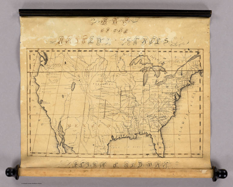
Ordway, Eliza S.
Full Title
Map Of The United States. Eliza S. Ordway.
Publisher
Manuscript
Author
Atwood, J.M.; Ensign & Thayer
Full Title
Pictorial Map Of The United States. 1849. Published by Ensign & Thayer, 50 Ann Street, New York. Drawn & Engraved by J.M. Atwood, New York. Entered ... 1847 by Phelps, Ensign's & Thayer ... New York.
Publisher
Ensigns & Thayer
Author
Alden, Albert
Full Title
Alden's Pictorial Map Of The United States Of North America. Barre, Mass.: Published By Albert Alden. Entered ... 1845, By Albert Alden ... Massachusetts. Printed At George Coolidge's Steam Power Printing Establishment, No. 1 Water Street, Boston. (inset) Map Of North America. (inset) Southern Part of Florida. (inset) Northern Boundary Of Maine ...
Publisher
Albert Alden
Author
Tanner, Henry S.
Full Title
A map of the United States, Mexico, Central America, California, Oregon, New Mexico, W. Indies &c. With the boundaries, of the several states, railroads, canals &c. by H.S. Tanner, No. 201 Broadway, New York. 1851.
Publisher
H.S. Tanner
Author
Burr, David H., 1803-1875
Full Title
Map of the United States Of North America, By David H. Burr. Geographer to the House of Representatives of the U.S. . Entered ... 12th Jan. 1842, by David H. Burr ... District of Columbia.
Publisher
John Arrowsmith
Author
[Colton, J. H., Johnson, A.J.]
Full Title
Johnson's New Illustrated & Embellished County Map Of The Republics Of North America With The Adjacent Islands & Countries, Compiled Drawn & Engraved From U. States Land & Coast Surveys, British Admiralty & other Reliable Sources. Under the Direction of A.J. Johnson. Published by J.H. Colton, 172, William Street, New York, Edition For Johnson & Browning. Richmond VA. 1860. Entered ... 1860 by J.H. Colton ... New York. Map Designed by A.J. Johnson. Engraved by D.G. Johnson, J.H. Goldthwait, W.S. Barnard, Wm. Wright, G. Rae Smith, F.H. King, James Duthie, J.L. White. (inset) Map Of The World on Mercator's Projection ...
Publisher
Johnson & Browning
Author
Mitchell, Samuel Augustus
Full Title
Mitchell's New National Map Exhibiting The United States With The North American British Provinces, Sandwich Islands, Mexico And Central America, Together with Cuba and other West India Islands. Philadelphia, Published By S. Augustus Mitchell. 1858. Engraved by W. Williams, Map Engraver Philadelphia. Constructed And Engraved By W. Williams, 33 South Fifth St. Philadelphia. Entered ... 1856 by S. Augustus Mitchell ... Pennsylvania. (inset) Map Of The World On The Mercator Projection ... (inset) Map Of The World On The Globular Projection ... (inset) Map Of The Sandwich Islands.
Publisher
S. Augustus Mitchell
Author
Lewis, Samuel
Full Title
The travellers guide. A new and correct map of the United States, including great portions of Missouri Territory, Upper & Lower Canada, Nova Scotia, New Brunswick, The Floridas, Spanish Provinces &c. Collected and compiled from the most undoubted authorities by Samuel Lewis, Geographer and Draftsman, 1819. Published, printed and coloured by Henry Charles, Philada. Copy Right secured according to law.
Publisher
Henry Charles
Author
[Gibbes, C.D., Holt, Warren]
Full Title
Map of the States Of California And Nevada. Carefully Compiled from the Latest Authentic Sources. California By Julius H. Von Schmidt, Arthur W. Keddie, And C.D. Gibbes, C.E.'s. Nevada By Chas. Drayton Gibbes C.E. S.B. Linton Engr. & Lithogr. 148-1/2 S. 4th Street, Philadelphia. Comprising Information obtained from the U.S. Coast And Land Surveys; State Geological Surveys, By Prof. J.D. Whitney; Railroad Surveys And The Results Of Explorations Made By Brevet Lieut. Col. R.S. Williamson, U.S.A., Henry DeGroot, C.D. Gibbes, And Others. Published by Warren Holt. No. 411 Kearny Street, San Francisco, Cal. 1869. Entered ... 1868, by Warren Holt ... California. (with 1 inset).
Publisher
Warren Holt
Author
[Johnson, A.J., Johnson, D. Griffing]
Full Title
Johnson's New Illustrated & Embellished County Map Of The Republics Of North America With The Adjacent Islands & Countries, Compiled Drawn & Engraved From U. States Land & Coast Surveys, British Admiralty & other Reliable Sources. By D. Griffing Johnson, New York & Washington. 1859. Entered ... 1856 by D.G. & A.J. Johnson ... New York. Map Designed by A.J. Johnson. Engraved by D.G. Johnson, J.H. Goldthwait, W.S. Barnard, Wm. Wright, G. Rae Smith, F.H. King, James Duthie, J.L. White. (inset) Johnson's Map Of The World on Mercator's Projection ...
Publisher
A.J. Johnson.
Author
Murray, J. Morrison
Full Title
Murray's Matchless Historical County, Railroad, Distance And Index Map Of The United States And Illustrated Reference Map Of The World. J. Morrison Murray, Publisher. Elizabeth, New Jersey. 1883. Copyrighted 1882. Price $4.00 ... (on verso) The Illustrated Reference Map Of The World, For Students, Business Men and Families ... Published By J.M. Murray ... (with 3 large inset maps).
Publisher
J. Morrison Murray
Author
Murray, J. Morrison
Full Title
The Illustrated Reference Map Of The World, For Students, Business Men and Families ... Published By J.M. Murray ... (with 3 large inset maps). (on verso) Murray's Matchless Historical County, Railroad, Distance And Index Map Of The United States And Illustrated Reference Map Of The World. J. Morrison Murray, Publisher. Elizabeth, New Jersey. 1883. Copyrighted 1882. Price $4.00 ...
Publisher
J. Morrison Murray
Author
Lloyd, J.T.
Full Title
Lloyd's Map of the Lower Mississippi River From St. Louis To The Gulf Of Mexico. Compiled From Government Surveys In The Topographical Bureau, Washington, D.C. Revised and corrected to the present time by Captains Bart and William Bowen ... Price, in sheets, Colored, 50 Cents per copy. Pocket Edition, $1.00. Mounted Edition on Rollers and Varnished, $1.00 ... J.T. Lloyd, Publisher. 164 Broadway, New York 1863. Entered ... 1862, by J.T. Lloyd ... New York. (on verso) Lloyd's New Map of the United States, The Canadas And New Brunswick ... 1864 ... Entered ... 1863, by J.T Lloyd ... New York. (untitled inset map of Southern Florida).
Publisher
J.T. Lloyd
Author
Lloyd, J.T.
Full Title
Lloyd's New Map of the United States, The Canadas And New Brunswick ... 1864 ... Entered ... 1863, by J.T Lloyd ... New York. (untitled inset map of Southern Florida). (on verso) Lloyd's Map of the Lower Mississippi River From St. Louis To The Gulf Of Mexico. Compiled From Government Surveys In The Topographical Bureau, Washington, D.C. Revised and corrected to the present time by Captains Bart and William Bowen ... Price, in sheets, Colored, 50 Cents per copy. Pocket Edition, $1.00. Mounted Edition on Rollers and Varnished, $1.00 ... J.T. Lloyd, Publisher. 164 Broadway, New York 1863. Entered ... 1862, by J.T. Lloyd ... New York.
Publisher
J.T. Lloyd
|