Browse All

1950 Southwestern United States & Northern Me … Wall Map n/a. |

2000 United States -- Physical Wall Map United States/Vereinigte Staaten. |

2001 United States -- Physical Wall Map United States of America. |

1963 United States: Western -- Physical-Polit … Wall Map Sectional Map of the United States, Sout … |

1948 United States -- Physiographic Diagram ( … Wall Map A Phsiographic Diagram of the United Sta … |

1983 United States -- Geology: Physiographic … Wall Map Generalized Structural Lithographic and … |

1985 China -- Physical-Political Wall Map China. |

1952 United States -- Pleistocene Eolian Depo … Wall Map Pleistocene Eolian Deposits of the Unite … |

1959 United States: East of the Rocky Mountai … Wall Map Glacial Map of the United States East of … |

1986 United States -- Political Wall Map The United States. |

1965 Northwest United States -- Physical Wall Map Pacific Northwest. |

1960 California -- Physical-Political Wall Map Natural Environment Physical Political M … |

1904 California -- Native Culture Wall Map Culture Areas of the Indians of Californ … |

1974 California -- Water Resources Developmen … Wall Map Surface Water Resources Development in C … |

1987 Oregon -- Physical Wall Map Oregon. |

1988 Hawaii -- Physical Wall Map Hawaii. |

1987 Idaho -- Physical-Political Wall Map Idaho. |

1987 Montana -- Physical Wall Map Montana. |

1987 Utah -- Physical Wall Map Utah. |

1984 Utah: Great Salt Lake and Vicinity -- La … Wall Map Great Salt Lake and Vicinity, Utah, Sate … |

1987 Nevada -- Physical Wall Map Nevada. |

1940 Iowa -- Physical-Political Wall Map Iowa, Physical and Political. |

1960 Pennsylvania -- Geology Wall Map Geologic Map of Pennsylvania. |

1986 Middle America -- Physical-Political Wall Map Mittelamerika. |

1948 Middle America -- Structure Wall Map Structural Divisions. |

1970 Middle America -- Native Cultures: Sauer Wall Map Native Cultures and Peoples. |

1845 Mitchell's National Map of the American … Wall Map Mitchell's National Map of the American … |

1866 The World. Western Hemisphere. Eastern H … Wall Map The World. Western Hemisphere. Eastern H … |

1871 Map Of Utah. [Manuscript Map, Wall Map] Map Of Utah. |

1907 Map Of California, Nevada And Southern O … Wall Map Weber's Township And County Map Of Calif … |
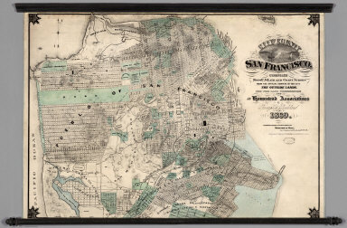
1869 City and County of San Francisco. Wall Map City and County of San Francisco. Compil … |

1849 Map of New Castle County, Delaware. Wall Map Map of New Castle County, Delaware, from … |

1814 South America Wall Map Outlines Of The Physical And Political D … |
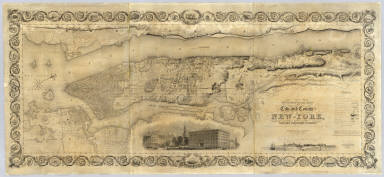
1836 City and County Of New - York. Wall Map Topographical Map Of The City and County … |

1852 City of New York Extending Northward to … Wall Map Map of the City of New York Extending No … |

1851 City And County Of New - York North Of 5 … Wall Map Map Of That Portion Of The City And Coun … |

1890 United States and territories. Wall Map Map of the United States and territories … |

1876 California and Nevada. Wall Map Map of the States of California and Neva … |

1833 Amherst. Wall Map A map of Amherst. With a view of the Col … |

1892 Post Route Map of the State of Texas Wall Map Post Route Map of the State of Texas wit … |

1888 Map of the City of Oakland and Surroundi … Wall Map Map of the City of Oakland and Surroundi … |

1920 (California) Wall Map (California) Eureka. Native Sons of the … |

1826 Map of the United States. Wall Map Map of The United States Compiled from t … |

1869 Sierra Nevada adjacent to the Yosemite V … Wall Map Geological Survey Of California, J.D. Wh … |
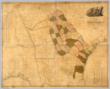
1818 Map Of The State of Georgia Wall Map Map Of The State of Georgia Prepared fro … |
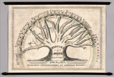
1845 Willard's Chronographer of American Hist … Wall Map Willard's Chronographer of American Hist … |

1945 Folklore Music Map of the United States. Wall Map Folklore Music Map of the United States … |
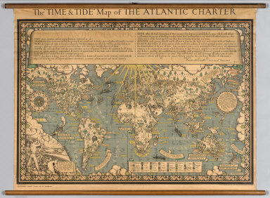
1942 The "Time & Tide" Map of The Atlantic Ch … Wall Map The "Time & Tide" Map of The Atlantic Ch … |

1852 Railroad and township map of Ohio Wall Map Railroad and township map of Ohio. Publi … |

1933 View: Geographical Publishing Company's … Wall Map Europe. North America. South America. |