Who What Where WhenREMOVEWHO
|
Author
Haack-Painke
Full Title
United States/Vereinigte Staaten.
Publisher
Justus Perthes
Author
Klett-Perthes
Full Title
United States of America.
Publisher
Justus Perthes Verlag Gotha GmbH
Author
Denoyer-Geppert Company
Full Title
Sectional Map of the United States, Southwestern/Northwestern United States.
Publisher
Denoyer-Geppert Company
Author
Lobeck, A.K.
Full Title
A Phsiographic Diagram of the United States, (Provisional Edition).
Publisher
A.J. Nystrom & Co.
Author
[United States Geological Survey (USGS), Bayer, Kenneth C.]
Full Title
Generalized Structural Lithographic and Physiographic Provinces in the Fold and Thrust Belts of the United States, (exclusive of Alaska and Hawaii).
Publisher
United States Geological Survey (USGS)
Author
[Justus Perthes, Haack, Berlt, H.]
Full Title
China.
Publisher
Hermann Haack
Author
The Geological Society of America
Full Title
Pleistocene Eolian Deposits of the United States, Alaska and parts of Canada.
Publisher
The Geological Society of America
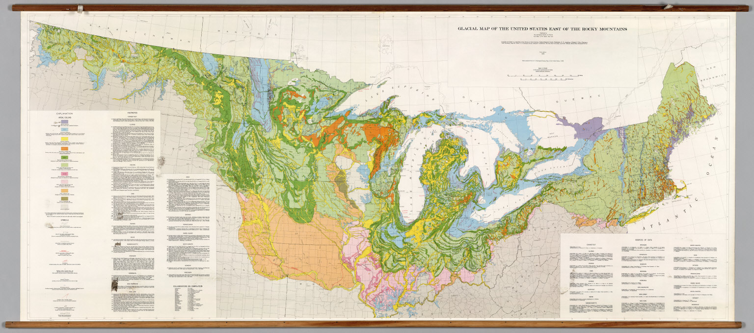
Author
[The Geological Society of America, Flint, Richard F.]
Full Title
Glacial Map of the United States East of the Rocky Mountains.
Publisher
The Geological Society of America
Author
[National Geographic Society, Garver Jr., John B., Garrett, Wilbur E.]
Full Title
The United States.
Publisher
National Geographic Society
Author
[Smith, Ronald, Babcock, Chester]
Full Title
Pacific Northwest.
Publisher
AJ Nystrom & Co
Author
Fairbanks, Harold W.
Full Title
Natural Environment Physical Political Map California.
Publisher
A.J. Nystrom & Co.
Author
Bagley, H.N.
Full Title
Culture Areas of the Indians of California, Showing also the tribes or local divisions.
Publisher
Bagley
Author
[State of California: The Resources Agency, Department of Water Resources]
Full Title
Surface Water Resources Development in California.
Publisher
California Department of Water Resources
Author
[United States Geological Survey (USGS), Allan Cartography, Raven Maps and Imaging]
Full Title
Oregon.
Publisher
Pikes Peak Lithographing
Author
[United States Geological Survey (USGS), Allan Cartography, Raven Maps and Imaging, Comstock, K.]
Full Title
Hawaii.
Publisher
Raven Maps and Images
Author
[United States Geological Survey (USGS), Allan Cartography, Raven Maps and Imaging]
Full Title
Idaho.
Publisher
Pikes Peak Lithographing
Author
[United States Geological Survey (USGS), Allan Cartography, Raven Maps and Imaging]
Full Title
Montana.
Publisher
Pikes Peak Lithographing
Author
[United States Geological Survey (USGS), Allan Cartography, Raven Maps and Imaging]
Full Title
Utah.
Publisher
Pikes Peak Lithography
Author
[United States Geological Survey (USGS), EROS Data Center]
Full Title
Great Salt Lake and Vicinity, Utah, Satellite Image Map.
Publisher
United States Geological Survey (USGS)
Author
[United States Geological Survey (USGS), Allan Cartography, Raven Maps and Imaging]
Full Title
Nevada.
Publisher
Pikes Peak Lithography
Author
[Denoyer, L.P., Blair, R. Baxter]
Full Title
Iowa, Physical and Political.
Publisher
Denoyer-Geppert Company
Author
[Topographic and Geologic Survey, Commonwealth of PA, Williams and Heintz Map Corporation]
Full Title
Geologic Map of Pennsylvania.
Publisher
Topographic and Geologic Survey, PA
Author
[Haack-Painke, Justus Perthes, Painke]
Full Title
Mittelamerika.
Publisher
Justus Perthes
Author
[Department of Geography, University of California at Berkeley, C.O.S., D.I.E.]
Full Title
Structural Divisions.
Publisher
Manuscript
Author
[Department of Geography, University of California at Berkeley, Sauer, Carl O.]
Full Title
Native Cultures and Peoples.
Publisher
Manuscript
Author
Mitchell, Samuel Augustus
Full Title
Mitchell's National Map of the American Republic Or United States Of North America. Together with Maps of the Vicinities Of Thirty-Two Of The Principal Cities And Towns in the Union. Published by S. Augustus Mitchell Philadelphia. 1845. No. 8-1/2 South Seventh Street. Drawn by J.H. Young. Engraved by J.H. Brightly. Entered ... 1842, by S. Augustus Mitchell ... Pennsylvania. (inset) Map Of the Southern Part Of Florida. (inset) Map Of The North-Eastern Boundary Of The United States ... (bordered by 32 additional inset maps).
Publisher
S. Augustus Mitchell
Author
Guyot, Arnold
Full Title
The World. Western Hemisphere. Eastern Hemisphere. Wall-Atlas by A. Guyot. Published by Chas. Scribner & Co. New York. The Major & Knapp Eng. Mfg. & Lith. Co. 449 Broadway, N.Y. Card Series. Entered ... 1866 by Charles Scribner & Co. ... New York.
Publisher
Scribner & Co.
Author
Anonymous
Full Title
Map Of Utah.
Publisher
Manuscript
Author
Weber, C.F.
Full Title
Weber's Township And County Map Of California, Nevada And Southern Oregon. Compiled & Drawn from the latest Data 1907. Published by C.F. Weber & Co. New Era Building, Corner Of Sutter And Polk Sts. San Francisco, Ca. 210 N. Main St. Los Angeles, Cal. Copyright, 1907, By C.F. Weber & Co. (inset) Map Of San Francisco And Adjacent Territory. (inset) Map Of Los Angeles And Adjacent Territory.
Publisher
C.F. Weber & Co.
Author
Goddard, George H.
Full Title
City and County of San Francisco. Compiled from U.S. Land and Coast Surveys from the Official Surveys of the City, The Outside Lands. The Tide Land Commission and the Homestead Associations by George H. Goddard C.E. 1869. Lithographed & Published by Britton & Rey, Corr. Commercial & Leidesdorff Sts. S. Entered ... 1869.
Publisher
Britton & Rey
Author
[Rea, Samuel M., Price, Jacob]
Full Title
Map of New Castle County, Delaware, from Original Surveys, Saml. M. Rea & Jacob Price. Published by Smith & Wisar, No. 15, Minor St., Philadelphia. 1849. (inset) Plan of the City of Wilmington. Compiled from Surveys by G.R. Riddle, C.E. 1847. Reduction by Rea & Price. Entered ... 1848 ... by Robert P. Smith.
Publisher
Smith and Wisar
Author
Arrowsmith, Aaron
Full Title
Outlines Of The Physical And Political Divisions Of South America: Delineated By A. Arrowsmith Partly From Scarce And Original Documents, Published Before The Year 1806 But Principally From Manuscript Maps & Surveys Made Between The Years 1771 And 1806, Corrected From Accurate Astronomical Observations To 1810. London, Published 4th January 1811 by A. Arrowsmith No. 10 Soho Square, Hydrographer to H.R.H. the Prince of Wales. Additions to 1814. Engraved by Edwd. Jones ... (inset map of the southern tip of South America).
Publisher
A. Arrowsmith
Author
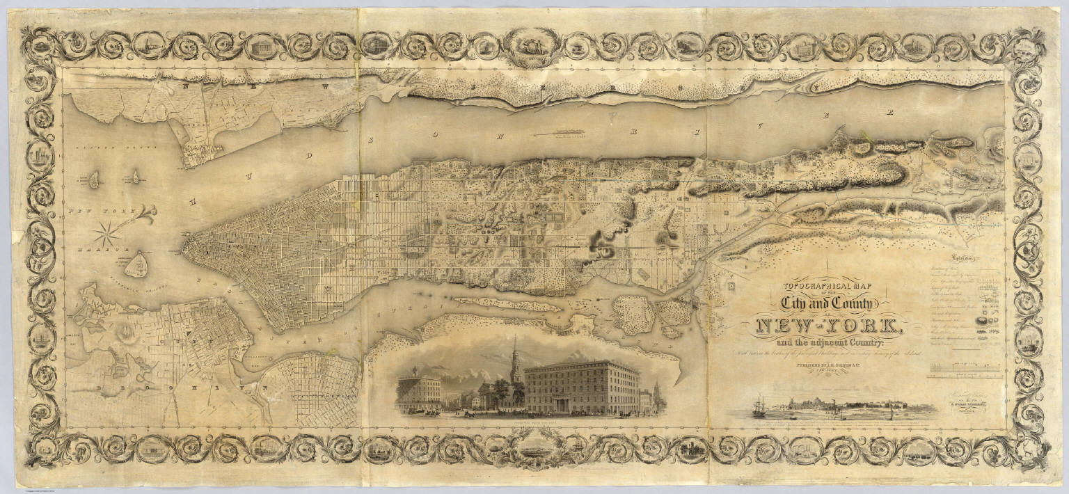
Colton, J. H.
Full Title
Topographical Map Of The City and County Of New - York, and the adjacent Country: With Views in the border of the principal Buildings and interesting Scenery of the Island. Published By J.H. Colton & Co. No. 4 Spruce St. New-York. 1836. Engraved & Printed by S. Stiles & Company, New-York. Entered ... 1836, by J.H. Colton & Co. ... New York.
Publisher
J.H. Colton & Co.
Author
Dripps, Matthew
Full Title
Map of the City of New York Extending Northward to Fiftieth St. Surveyed and drawn by John F. Harrison C.E. Published by M. Dripps...1852.
Publisher
M. Dripps
Author
Dripps, Matthew
Full Title
Map Of That Portion Of The City And County Of New - York North Of 50th St. Surveyed & Drawn by R.A. Jones, C.E. Published by M. Dripps, 103 Fulton St. N.Y. 1851. (inset) Westchester County.
Publisher
M. Dripps
Author
U.S. General Land Office
Full Title
Map of the United States and territories, with adjacent parts of Canada and Mexico also part of the West India islands, showing the extent of public surveys, Indian, military, and forest reservations, rail roads, canals, national parks and other details, compiled from official surveys of the General Land Office and other authentic sources. Under the direction of the Hon. Lewis A. Groff, Commissioner. A.F. Dinsmore, Chief, Draughting Division. 1890. Isaac Friedenwald, Photo. Litho. Balto. Md. (inset) Territory of Alaska.
Publisher
Isaac Friedenwald Photo Litho.
Author
[Gibbes, C.D., Holt, Warren]
Full Title
Map of the States of California and Nevada. Carefully Compiled from the Latest Authentic Sources. California by Julius H. Von Schmidt, Arthur W. Keddie, and C.D. Gibbes, C.E.'s. Nevada by Chas. Drayton Gibbes C.E. Comprising Information obtained from the U.S. Coast and Land Surveys; State Geological Surveys, By Prof. J.D. Whitney; Railroad Surveys And The Results of Explorations Made By Brevet Lieut. Col. R.S. Williamson, U.S.A., Henry DeGroot, C.D. Gibbes, And Others. Entered ... 1876 by Warren Holt ... California.
Publisher
Warren Holt
Author
[Adams, Charles B., Gray, Alonzo]
Full Title
A map of Amherst. With a view of the College and Mount Pleasant Institution. By Alonzo Gray & Charles B. Adams. Amherst College, May 1833. Pendleton's Lithography, Boston.
Publisher
Pendleton's Lithography
Author
[Roeser, C. (Charles), United States. Post Office Dept.]
Full Title
Post Route Map of the State of Texas with adjacent parts of Louisiana, Arkansas, Indian Territory and of the Republic of Mexico. Showing Post Offices with the Intermediate Distances and Mail Routes in operation on the 1st of December, 1892....1889
Publisher
U.S. Post Office
Author
Henkenius, J.C.
Full Title
Map of the City of Oakland and Surroundings. Compiled from Official and Private Surveys. by J.C. Henkenius. Published by Woodward and Gamble, Real Estate and General Agents, 902 Broadway, Oakland. 1888. Britton & Rey Lith., S.F. Cal. Entered...1887.
Publisher
[Woodward and Gamble, Britton & Rey]
Author
[Native Sons of the Golden West, London, M.C., Cahill, B.J.S.]
Full Title
(California) Eureka. Native Sons of the Golden West. Founded July 11, 1875 by General A.M. Winn, San Francisco, California. Copyright by M.C. London and B.J.S. Cahill. 1920.
Publisher
No. publisher
Author
[Huntington, Eleazer, Willard, A.]
Full Title
Map of The United States Compiled from the most Authentic Sources. Published By E. Huntington & A. Willard, Hartford, 1826. Entered ... September, 1826. (with 5 inset maps).
Publisher
Huntington & Willard
Author
[Hoffman, Hoffmann, Charles F., J.T. Gardner, Whitney, J.D., Geological Survey of California]
Full Title
Geological Survey Of California, J.D. Whitney, State Geologist. Map of a portion of the Sierra Nevada adjacent to the Yosemite Valley from surveys made by Chs. F. Hoffmann and J.T. Gardner, 1863-1867.Map of a portion of the Sierra Nevada adjacent to the Yosemite Valley.
Publisher
No Publisher
Author
[Early, Eleazer, Sturges, Daniel]
Full Title
Map Of The State of Georgia Prepared from actual Surveys and other Documents for Eleazer Early By Daniel Sturges. Entered According to Act of Congress by Eleazer Early Proprietor. Engraved by Saml. Harrison 1818. Published & Sold By Eleazer Early Savannah Georgia and By John Melish & Samuel Harrison Philadelphia.
Publisher
Eleazer Early
Author
Willard, Emma
Full Title
Willard's Chronographer of American History. History of the U. States or Republic of America. Historic Tree.
Publisher
A.S. Barnes & Co.
Author
[Laurence, Dorthea Dix (1899-1979), Cimino, Harry (1898-]
Full Title
Folklore Music Map of the United States by Dorthea Dix Laurence from the Primer of American Music.
Publisher
Hagstrom Company, Inc.
Author
Gill, Leslie MacDonald, 1884-1947
Full Title
The "Time & Tide" Map of The Atlantic Charter.
Publisher
The London Geographical Institute
Author
Horace Thayer & Co.
Full Title
Railroad and township map of Ohio. Published by Horace Thayer & Co., 50 Ann Street, New York. Entered ... 1852 by Horace Thayer & co., ... New York.
Publisher
Horace Thayer & Co.
|