Who What Where WhenREMOVE |
Author
Berghaus, Heinrich
Full Title
Erdkarte zur Ubersicht Der Vertheilung des Starren und Flussigen, der Verschiedenheit der Oberflachen Gestaltung. Nebst Andeutungen zu Einer Arithmetisch-Geographischen Entwickelung der Wagerechten und Senkrechten Ausdehnungen. 3te Abtheilung: Geologie, No. 1. Gezeichnet v. F. Schelle. Gestochen v. Wilh. Jattnig in Berlin. Gotha, J. Perthes, 1839. Bearbeitet in der Geographischen Kunstschule zu Potsdam.
Publisher
Justus Perthes
Author
Berghaus, Heinrich
Full Title
Bergketten In Asien Und Europa. 3te Abtheilung: Geologie, No. 2. Potsdam, gez. u. gest. in der geogr. Kunstschule. Gotha, bei Justus Perthes, 1842.
Publisher
Justus Perthes
Author
Berghaus, Heinrich
Full Title
Europa's Haupt-Gebirgs Systeme. 3te Abtheilung: Geologie, No. 3. Gez. u. gest. in der geograph. Kunstschule zu Potsdam. Gotha bei Justus Perthes. 1842.
Publisher
Justus Perthes
Author
Berghaus, Heinrich
Full Title
Europa in Geologischer Beziehung nach den Hauptmassen der Gebirgs-Formationen. 3te Abtheilung: Geologie, No. 4. Gotha, bei J. Perthes. 1843.
Publisher
Justus Perthes
Author
Berghaus, Heinrich
Full Title
Karte von Sud-Amerika zur Ubersicht der Unebenheiten des Bodens. 3te Abtheilung: Geologie, No. 5. Potsdam, gez. u. gest. in der geogr. Kunstschule. Gotha, bei Justus Perthes, 1843.
Publisher
Justus Perthes
Author
[Berghaus, Heinrich, Humboldt, Alexander von, 1769-1859]
Full Title
Bergketten in Nord-Amerika. 3te Abtheilung: Geologie, No. 6. Potsdam, gez. u. gest. in der geogr. Kunstschule. Gotha, bei Justus Perthes, 1842.
Publisher
Justus Perthes
Author
Berghaus, Heinrich
Full Title
Specialia vom Vulkan Gurtel des Atlantischen Oceans. 3te Abtheilung: Geologie, No. 8. Gezeichnet von F. Schelle. Gestochen von Joh. Carl Ausfeld. Gotha, J. Perthes, 1839.
Publisher
Justus Perthes
Author
Berghaus, Heinrich
Full Title
Die Vulkanreihe von Guatemala, die Landengen von Tehuantepec, Nicaragua und Panama, und die Central Vulkane der Sud See. 3te Abtheilung: Geologie, No. 10. Potsdam, gez. u. gest. in der geogr. Kunstschule. Gotha, bei J. Perthes, 1840.
Publisher
Justus Perthes
Author
Berghaus, Heinrich
Full Title
Spezial-Karte vom Riesen-Gebirge. 3te Abtheilung: Geologie, No. 13. Gezeichnet u. gestochen in der geogr. Kunstschule zu Potsdam. Gotha, J. Perthes, 1843.
Publisher
Justus Perthes
Author
Berghaus, Heinrich
Full Title
Vermischtes zur Geologie. 3te Abtheilung: Geologie, No. 15. Potsdam, gez. u. gest. in der geogr. Kunstschule. Gotha, bei J. Perthes, 1844.
Publisher
Justus Perthes
Author
Colton, G.W.
Full Title
Mountains & Rivers. Published by J.H. Colton & Co. No. 172 William St. New York. Entered ... 1855, by J.H. Colton & Co. ... New York. No. II-No. III.
Publisher
J.H. Colton
Author
Colton, G.W.
Full Title
Mountains & Rivers. Published by G. W. & C. B. Colton & Co., No. 182 William St. New York.
Publisher
G. W & C. B. Colton & Co.
Author
Colton, G.W.
Full Title
Mountains & Rivers.
Publisher
G. W & C. B. Colton & Co.
Author
Colton, G.W.
Full Title
Mountains & Rivers. Published by G.W. & C.B. Colton, No. 172 William St., New York.
Publisher
G.W. & C.B. Colton
Author
Johnson, A.J.
Full Title
Mountains & Rivers. By Johnson and Ward. (to accompany) Johnson's New Illustrated (Steel Plate) Family Atlas, With Physical Geography, And With Descriptions Geographical, Statistical, And Historical ... By Richard Swainson Fisher, M.D. ... Maps Compiled, Drawn, And Engraved Under The Supervision Of J.H. Colton And A.J. Johnson. New York: Johnson And Ward, Successors To Johnson And Browning (Successors To J.H. Colton And Company,) No. 113 Fulton Street. 1864. Entered ... One Thousand Eight Hundred and Sixty-four, by A.J. Johnson ... New York.
Publisher
Johnson and Ward
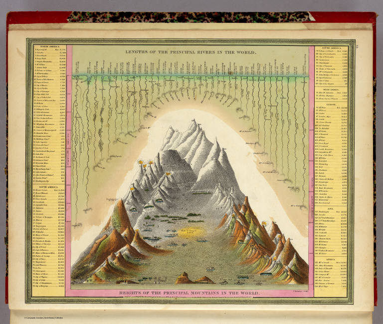
Author
Mitchell, Samuel Augustus
Full Title
Lengths of the Principal Rivers in the World. Heights of the Principal Mountains in the World. F. Humphreys, Sculpt. Entered ... 1850 by Thomas, Cowperthwait & Co. ... Pennsylvania.
Publisher
Cowperthwait, Desilver & Butler
Author
Radefeld, Carl Christian Franz, 1788-1874
Full Title
Spanien, westliche Halfte. Nach den besten Quellen entworf. u. gezeichnet, von Hauptm. Radefeld. 1847. (with) Madrid. Stich, Druck und Verlag des Bibliographischen Instituts zu Hildburghausen, (1860)
Publisher
Bibliographischen Instituts
Author
Radefeld, Carl Christian Franz, 1788-1874
Full Title
(Spanien, oestliche Halfte. Nach den besten Quellen entworf. u. gezeichnet, von Hauptm. Radefeld. 1847) (with Canarische Inseln) (with Fernando Po) Stich, Druck und Verlag des Bibliographischen Instituts zu Hildburghausen, (1860)
Publisher
Bibliographischen Instituts
Author
Grassl, J. (Joseph)
Full Title
Karte des Thuringer-Wald-Gebirges zugleich special Karte des Herzogthums Sachs-Meiningen-Hildburghausen, des Furstenthums Coburg und der Schwarzburgischen Furstenthumer Rudolstadt und Sondershausen. (with) Grundriss von Hildburghausen. (with) Grundriss von Coburg. Entworf. u. gezeichnet von J. Graessl. 1850. Stich, Druck und Verlag des Bibliographischen Instituts in Hildburghausen, (1860)
Publisher
Bibliographischen Instituts
Author
Gotthard, A.
Full Title
Der Harz. Gezeichnet v. Prem. Leutn. Gotthardt. 1852. Stich, Druck und Verlag des Bibliographischen Instituts in Hildburghausen, (1860)
Publisher
Bibliographischen Instituts
Author
Meyer, Joseph, 1796-1856
Full Title
Neueste Karte von Ungarn, Galizien, Slavonien und Croatien, Siebenburgen und dem Militairgrenzland. 1847. Aus der Geographischen Graviranstalt des Bibliographischen Instituts zu Hildburghausen, Amsterdam, Paris u. Philadelphia, (1860)
Publisher
Bibliographischen Instituts
Author
Radefeld, Carl Christian Franz, 1788-1874
Full Title
Bergsystem von Nord-America, 1848. Nach den neuesten Forshungen entw. u. gez. v. Hauptm. C. Radefeld. H. Schleifmann sc. Stich, Druck und Verlag des Bibliographischen Instituts in Hildburghausen, (1860)
Publisher
Bibliographischen Instituts
Author
Radefeld, Carl Christian Franz, 1788-1874
Full Title
Sud-America's Bergsysteme und Stromgebiete. Nach den besten Quellen entworf. u. gezeichnet von Hauptm. Radefeld. 1847. Stich, Druck und Verlag des Bibliographischen Instituts in Hildburghausen, (1860)
Publisher
Bibliographischen Instituts
Author
Flemming, Carl
Full Title
Fluss- und Gebirgs-Karte von Mittel-Europa. Entw. u. gez. v. F. Handtke. H. Muller lith. Druck u. Verlag v. C. Flemming in Glogau. (1855)
Publisher
C. Flemming
Author
[Brue, Adrien Hubert, 1786-1832, Humboldt, Alexander von, 1769-1859, Picquet, C.]
Full Title
Carte des republiques de la Nle. Grenade, de Venezuela et de l'Equateur formees de l'ancien Etat de Colombie; et des Guyanes Francaise, Hollandaise et Anglaise. (with) Profil de l'Amerique Meridionale de l'est a l'ouest, par M.A. de Humboldt. (with) Hauteurs comparees des villes, coupe ideale des Andes, de 21 (degrees) de latitude boreale et 13 (degrees) de lat. australe, par M.A. de Humboldt. Redigee par A. Brue, Geographe du Roi. Revue et augmentee par Ch. Picquet, Geographe du Roi et du Duc d'Orleans. Paris, 1836. Chez Chles. Picquet, Quai Conti No. 17, pres du Pont des Arts.
Publisher
C. Picquet
Author
Stein, Christ. Gottfr. Dan.
Full Title
Hemisphaeren. Entworfen und gezeichnet von G. Heck. Gestochen von R. Schmidt u. H. Eberhardt. J.C. Hinrichs'sche Buchhandlung, Leipzig. (1865)
Publisher
J.C. Hinrichs'sche Buch- und Landkartenhandlung
Author
Fullarton, A. & Co.
Full Title
The World in Hemispheres with Comparative Views of the Heights of the Principal Mountains and Basins of the principal Rivers on the Globe. I. By G.H. Swanston. Published by A. Fullarton & Co. Edinburgh, London & Dublin.
Publisher
A. Fullarton & Co.
Author
[Brue, Adrien Hubert, 1786-1832, Humboldt, Alexander von, 1769-1859]
Full Title
Carte generale de Colombie, de la Guyane Francaise, Hollandaise et Anglaise. (with) Profil de l'Amerique Meridionale de l'est a l'ouest, par M.A. de Humboldt. (with) Hauteurs comparees des villes, coupe ideale des Andes, de 21 (degrees) de latitude boreale et 13 (degrees) de lat. australe, par M.A. de Humboldt. Redigee par A. Brue, Geographe du Roi, d'apres les observations astronomiques de M. Alex. de Humboldt ... Paris, 1826. Chez l'Auteur, rue des Macons-Sorbonne, no. 9, et chez les principaux m(archan)ds de cartes geographiques.
Publisher
A. Brue
Author
[Perrot, A. M. (Aristide Michel), 1793-1879, Vandermaelen, Philippe, 1795-1869]
Full Title
Tableau comparatif des principales hauteurs du globe. D'apres A.M. Perrot. (Dresse par Ph. Vandermaelen, lithographie par H. Ode. Premier partie. - Europe. Bruxelles. 1827)
Publisher
Ph. Vandermaelen
Full Title
Western Hemisphere. Copyright 1887 by Wm. M. Bradley & Bro. (1890)
Publisher
John Y. Huber & Co.
Full Title
Eastern Hemisphere. Copyright 1887 by Wm. M. Bradley & Bro. (1890)
Publisher
John Y. Huber & Co.
Full Title
Western and Eastern Hemispheres. (with) Hemisphere containing greatest amount of water. (with) River systems of the World. (with) Hemisphere containing greatest amount of land. (Published at the office of "The Times," London, 1895)
Publisher
The Times
Full Title
Karte des Weltverkehrs und der Meeresstromungen in Mercators Projektion. (with) Schematisches Profil einiger Haupt-Berggipfel der Erde. (Richard Andree. Herausgegeben von der Geographischen Anstalt von Velhagen & Klasing in Leipzig. 1881)
Publisher
Velhagen & Klasing
Full Title
L'Europe avec trois mers, trois fleuves & trois chaines de montagnes qui sont comunes a plus d'un pays. (1693)
Publisher
No Publisher
Full Title
L'Europe (avec trois mers, trois fleuves & trois chaines de montagnes qui sont comunes a plus d'un pays. 1693)
Publisher
No Publisher
Author
Mitchell, Samuel Augustus
Full Title
Western Hemisphere. Entered ... 1879 by S. Augustus Mitchell ... Washington. (1880)
Publisher
S.A. Mitchell
Author
Mitchell, Samuel Augustus
Full Title
Eastern Hemisphere. Entered ... 1879 by S. Augustus Mitchell ... Washington. (1880)
Publisher
S.A. Mitchell
Author
Fenner, Rest.
Full Title
A comparative view of the heights of the principal mountains and lengths of the principal rivers of the World. Fenner Sc., Paternoster Row. (London, Joseph Thomas, 1835)
Publisher
Joseph Thomas
Author
Lucas, Fielding Jr.
Full Title
Comparative Height of the Principal Mountains and other Elevations in the World. J. Cone Sc. Published by F. Lucas Jr. Baltimore.
Publisher
Fielding Lucas Jr.
Author
Stieler, Adolf
Full Title
Fluss Und Bergkarte Von Deutschland Und Den Anliegenden Landern entworfen u. gez. von Adolf Stieler 1820. Neue vermehrte Auflage durch Herm. Berghaus. 1857. Druck von C. Hellfarth in Gotha. Gotha: Justus Perthes 1873.
Publisher
Justus Perthes
Author
[Andriveau-Goujon, J., Bruguiere, Louis]
Full Title
Tableau comparatif de la forme et de la hauteur des principales montagnes du globe terrestre, dedie a Monsieur le Baron, Alexdre. de Humboldt. A Paris, chez J. Andriveau-Goujon, Rue du Bac, no. 17. Par son tres humble et tres obeissant serviteur Louis Bruguiere. Grave par Ambroise Tardieu. (1850)
Publisher
J. Andriveau-Goujon
Author
Mitchell, Samuel Augustus
Full Title
Heights Of The Principal Mountains In The World. Lengths Of The Principal Rivers In The World. F. Humphrys. Sculpt. Entered ... 1846, H.N. Burroughs ... Pennsylvania.
Publisher
S.A. Mitchell
Author
Berghaus, Heinrich
Full Title
Die Isothermkurven Der Nordlichen Halbkugel. 1ste. Abtheilung: Meteorologie No. 2. Gezeichnet v. Bar, Berghaus, u. Schelle. In Potsdam Gestochen von K. Kolbe. Gotha, J. Perthes. 1838.
Publisher
Justus Perthes
Author
[Goujon, J, Andriveau, J.]
Full Title
Tableau Comparatif et Figure de La Hauteur des Principales Montagnes et du Cours des Principaux Fleuves due Monde. Les Fleuves graves par Dumortier. Les Montagnes par A. Hocquart. La Lettre par Arnoul. Paris. Chez J. Goujon & J. Andriveau. Geographes - Editeurs. Rue du Bac, No. 6, Pres le Pont Royal. 1836.
Publisher
Goujon, J.; Andriveau, J.
Author
Colton, G.W.
Full Title
Mountains & Rivers.
Publisher
J. H. Colton.
Author
Colton, G.W.
Full Title
Mountains & Rivers. Published by G. W. & C. B. Colton & Co., No. 172 William St. New York.
Publisher
G. W & C. B. Colton & Co.
Author
Colton, G.W.
Full Title
(Index to) Principal Mountains in the World.
Publisher
G. W & C. B. Colton & Co.
Author
Hammond, C.S.
Full Title
The Northern and Northwestern Lakes including Canals and Tributary Navigable Streams.
Publisher
Garden City Publishing Company, Inc.
Author
Gray, Ormando Willis
Full Title
Mountains & Rivers.
Publisher
Stedman, Brown & Lyon
Author
Finley, Anthony
Full Title
Table of the Comparative Heights of the Principal Mountains &c. in the World ... Published by A. Finley Philada. Young & Delleker Sc.
Publisher
Anthony Finley
|