Who What Where WhenREMOVE |
REFINE
Browse All : Physical of Eastern Hemisphere from 1851
1-37 of 37
Author
Schonberg & Co.
Full Title
Minnesota. Virginia East & West.
Publisher
Schonberg & Co.
Author
Cram, George Franklin
Full Title
Western Half of Virginia and West Virginia, Engraved Expressly for the Standard Atlas of the World.
Publisher
George F. Cram
Author
Cram, George Franklin
Full Title
Eastern Half of Virginia and West Virginia, Engraved Expressly for the Standard Atlas of the World.
Publisher
George F. Cram
Author
Cram, George Franklin
Full Title
A Railroad and County Map, Virginia, W. Virginia.
Publisher
George F. Cram
Author
Colton, G.W.
Full Title
Colton's Virginia. (inset) Richmond, Henrico County. Manchester and Spring Hill, Chesterfield Co. Norfolk, Portsmouth and Gosport. Published by G.W. & C.B. Colton & Co., No. 172 William St. New York.
Publisher
G.W. & C.B. Colton
Author
Cram, George Franklin
Full Title
Western Half of Virginia and West Virginia.
Publisher
George F. Cram
Author
Cram, George Franklin
Full Title
Eastern Half of Virginia and West Virginia.
Publisher
George F. Cram
Author
Cram, George Franklin
Full Title
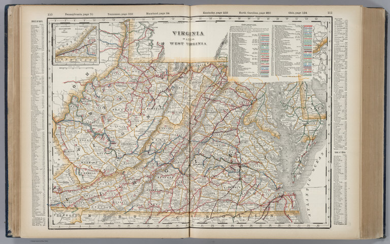
(Composite of) Virginia and West Virginia.
Publisher
George F. Cram
Author
Cram, George Franklin
Full Title
Virginia and West Virginia.
Publisher
George F. Cram
Author
Meyer, Joseph, 1796-1856
Full Title
Neueste Karte von Virginia mit seinen Canaelen, Strassen, Eisenbahnen, Entfernungen der Hauptpunkte und Dampfschiff Routen. Nach den bessten Quellen entworfen und gezeichnet, 1845. (with) Profil des Chesapeake & Ohio Canal's. Aus der Geographischen Graviranstalt des Bibliographischen Instituts zu Hildburghausen, Amsterdam, Paris u. Philadelphia, (1860)
Publisher
Bibliographischen Instituts
Author
[Bayer, Herbert, Container Corporation of America]
Full Title
West Virginia. Virginia. U.S. State. (insets) (Vicinity of Wheeling, Clarksburg, and Charleston).
Publisher
Container Corporation of America
Author
Johnson, A.J.
Full Title
Johnson's Virginia, Delaware, Maryland & West Virginia. Entered ... 1864.
Publisher
A.J. Johnson
Author
Johnson, A.J.
Full Title
Johnson's Virginia, Delaware, Maryland, and West Virginia. Published by A. J. Johnson, New York. Johnson's Delaware and Maryland. Published by A. J. Johnson, New York. 46. 47. Entered according to the Act of Congress, in the year 1864, by A.J. Johnson in the Clerk's Office of the District Court of the United States for the Southern District of New York.
Publisher
A.J. Johnson.
Full Title
Virginia. (Written and engraved by Jos. Perkins. 1845)
Publisher
Tanner's Geographical Establishment
Full Title
Virginia. (Philadelphia: Published by Robert Desilver, 1822)
Publisher
Robert DeSilver
Author
Mitchell, Samuel Augustus Jr.
Full Title
County map of Virginia and West Virginia. Drawn & Engd. by W.H. Gamble Phila. Entered ... 1863 by S. Augustus Mitchell, Jr. ... Pennsylvania.
Publisher
S.A. Mitchell Jr.
Author
Mitchell, Samuel Augustus Jr.
Full Title
County map of Virginia and West Virginia. Drawn & engraved by W.H. Gamble Phila. Entered ... 1874, by S. Augustus Mitchell ... Washington.
Publisher
S.A. Mitchell Jr.
Author
Mitchell, Samuel Augustus Jr.
Full Title
County map of Virginia and West Virginia. Drawn & Engd. by W.H. Gamble, Philad. Entered ... 1877 by S. Augustus Mitchell, . ... Washington.
Publisher
S.A. Mitchell Jr.
Author
Mitchell, Samuel Augustus
Full Title
A New Map of Virginia with the Canals, Roads & Distances.
Publisher
Thomas, Cowperthwait & Co.
Author
Mitchell, Samuel Augustus Jr.
Full Title
County map of Virginia and West Virginia. Drawn & Engd. by W.H. Gamble Phila. Entered ... 1867 by S. Augustus Mitchell, Jr. ... Pennsylvania.
Publisher
S.A. Mitchell Jr.
Author
Lewis, Samuel
Full Title
Virginia. S. Lewis del. Tanner sc. (Published by John Conrad & Co., Philadelphia. 1804)
Publisher
J. Conrad
Author
Lewis, Samuel
Full Title
Virginia. S. Lewis del. (Boston: Published by Thomas & Andrews. 1812)
Publisher
Thomas & Andrews
Full Title
County map of the states of Delaware, Maryland, Virginia and West Virginia. Copyright 1887 by Wm. M. Bradley & Bro. (1890)
Publisher
John Y. Huber & Co.
Author
Mitchell, Samuel Augustus
Full Title
County map of Virginia and West Virginia. Drawn and engd. by W.H. Gamble, Phila. Entered ... 1870 by S. Augustus Mitchell, Jr. ... Pennsylvania.
Publisher
[R.A. Campbell, S.A. Mitchell, Jr.]
Author
Mitchell, Samuel Augustus
Full Title
County map of Virginia and West Virginia. Drawn & engd. (by) W.H. Gamble, Phila. Entered ... 1879 by S. Augustus Mitchell ... Washington. (1880)
Publisher
S.A. Mitchell
Author
Mitchell, Samuel Augustus
Full Title
A New Map of the State of Virginia Exhibiting its Internal Improvements, Road Distances &c. by J.H. Young. Philadelphia, Published By Charles Desilver, No. 1229 Chesnut Street. 1862. Entered according to Act of Congress in the year 1862 by Charles Desilver in the Clerk's office if the District Court of the Eastern District of Pennsylvania. 17.
Publisher
Charles Desilver.
Author
Cram, George Franklin
Full Title
New Rail Road and County Map of Deleware (Delaware), Maryland, Virginia & West Virginia.
Publisher
A.C. Shewey and Co.
Author
Gray, O.W.
Full Title
Gray's Atlas Map of Virginia & West Virginia. (insets) Richmond. Norfolk.
Publisher
Stedman, Brown & Lyon
Author
Appleton, D. & Co.
Full Title
Map of Virginia, West Virginia, Maryland and Delaware. Copyright 1891 by Matthews-Northrup Co. ... Buffalo, New York. (insets) District of Columbia. (with) Part of Lee County, Virginia. (to accompany) The Library Atlas Of Modern Geography ... New York, D. Appleton And Company 1892. (on upper margin) Virginia, West Virginia, Maryland and Delaware 101
Publisher
D. Appleton & Co.
Author
Johnson, A.J.
Full Title
Johnson's Virginia, Delaware, Maryland, and West Virginia, Published By Johnson and Ward.
Publisher
Johnson and Ward
Author
Gray, Ormando Willis
Full Title
Philadelphia. Gray's Atlas Map of Virginia & West Virginia. (insets:) Richmond ... Manchester ... Spring Hill; Norfolk, Portsmouth, and Gosport.
Publisher
Stedman, Brown & Lyon
Author
Mitchell, Samuel Augustus Jr.
Full Title
County map of the states of Delaware, Maryland, Virginia and West Virginia. Copyright by S. Augustus Mitchell 1884.
Publisher
Wm. M. Bradley & Bro.
Author
Mitchell, Samuel Augustus
Full Title
A New Map of the State of Virginia Exhibiting its Internal Improvements, Road Distances &c. by J.H. Young. Philadelphia, Published By Charles Desilver, No. 714 Chestnut Street. Entered according to Act of Congress in the year 1856 by Charles Desilver in the Clerk's office if the District Court of the Eastern District of Pennsylvania. 17.
Publisher
Charles Desilver.
Full Title
County map of the states of Delaware, Maryland, Virginia and West Virginia. Copyright 1886 by Wm. M. Bradley & Bro.
Publisher
Wm. M. Bradley & Bro.
Author
Johnson, A.J.
Full Title
Johnson's Virginia, Delaware, Maryland, and West Virginia. Published by Alvin J. Johnson & Co., New York. Johnson's Delaware and Maryland. Published by A. J. Johnson, New York. 46. 47. Entered according to the Act of Congress, in the year 1864, by A.J. Johnson in the Clerk's Office of the District Court of the United States for the Southern District of New York.
Publisher
Alvin J. Johnson & Co.
Author
Carey, Mathew
Full Title
A Correct Map of Virginia.
Publisher
M. Carey and Son
Author
Gray, Ormando Willis
Full Title
Gray's New Topographical Map of Virginia and West Virginia. By Frank A. Gray. (inset) Environs of Harpers Ferry. (inset) Hampton Roads and the Approaches. (inset) Hypsometric Sketch of Virginia and West Virginia. (inset) Norfolk Harbor. Philadelphia: O.W. Gray & Son.
Publisher
O.W. Gray & Son
1-37 of 37
|