Browse All

1811 Poland, Prussia. World Atlas Poland & Prussia, from the latest author … |

1811 Netherlands, Germany W. of Rhine. World Atlas Netherlands and that part of Germany wes … |

1811 Germany. World Atlas A new map of Germany. London, Published … |

1811 Switzerland. World Atlas Switzerland. Published September 2, 1811 … |

1811 Hungary. World Atlas Hungary. Published August 31st, 1811 by … |

1811 Spain, Portugal. World Atlas A new map of Spain and Portugal, divided … |

1811 Italy. World Atlas Italy. Published May 21st 1811, by Wm. D … |

1811 Turkey In Europe. World Atlas A new map of Turkey in Europe. London, P … |

1811 Turkey in Asia. World Atlas A new map of Turkey in Asia. London, Pub … |

1811 Persia. World Atlas Persia. London, Published August 1st 181 … |

1811 Asia. World Atlas A new map of Asia, from the best authori … |

1811 Africa. World Atlas A new map of Africa from recent authorit … |

1811 West India Islands. World Atlas The West India Islands. London, Publishe … |

1811 Greece. World Atlas Greece. London, Published August 12th, 1 … |

1811 World Mercator's proj. World Atlas A new chart of the World on Mercator's p … |

1811 Romanum Imperium. World Atlas Romanum Imperium. Published November 13t … |

1811 Graecia Antiqua. World Atlas Graecia Antiqua. Published October 1st, … |

1802 E. Hemisphere. World Atlas Eastern Hemisphere. London, published by … |

1802 W. Hemisphere. World Atlas Western Hemisphere. London, published by … |
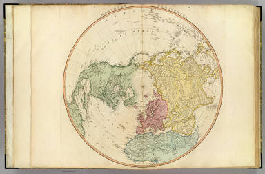
1802 N. Hemisphere. World Atlas Northern Hemisphere. London, published b … |

1802 S. Hemisphere. World Atlas Southern Hemisphere. London, published b … |

1791 Europe. World Atlas Europe, exhibiting its principal states … |

1801 England, Wales, Scotland. World Atlas A map of England, Wales & Scotland, desc … |

1778 N. Britain, Scotland. World Atlas North Britain or Scotland, divided into … |

1798 Ireland. World Atlas A map of Ireland divided into provinces … |

1781 Jersey, Guernsey. World Atlas A chart of the islands of Jersey and Gue … |

1794 British Channel, Bay of Biscay. World Atlas A chart of the British Channel and the B … |

1796 North Sea, Kattegat. World Atlas The North Sea with the Kattegat, from th … |

1794 Seven United Provinces. World Atlas A map of the Seven United Provinces with … |

1789 Netherlands or Low Countries. World Atlas A map of the Austrian possessions in the … |

1790 France. World Atlas France, divided into provinces. By W. Fa … |

1792 France. World Atlas France, divided into metropolitan circle … |

1795 N. France. World Atlas A map of the northern part of France, wi … |

1799 SE France. World Atlas The southeastern part of France which in … |

1796 Spain, Portugal. World Atlas Spain and Portugal; divided into their r … |

1797 Portugal. World Atlas Chorographical map of the Kingdom of Por … |

1780 Coasts Spain, Portugal, Barbary. World Atlas A chart of the coasts of Spain and Portu … |

1785 Mediterranean W. World Atlas A map of the Mediterranean Sea with the … |

1785 Mediterranean E. World Atlas (A map of the Mediterranean Sea with the … |

1785 Composite: Mediterranean. World Atlas (Composite of) A map of the Mediterranea … |

1783 Gibraltar. World Atlas Plan of the bay, rock and town of Gibral … |

1800 Italy N. World Atlas Italy with the addition of the southern … |

1800 Italy S. World Atlas (Italy with the addition of the southern … |

1800 Composite: Italy. World Atlas (Composite of) Italy with the addition o … |

1799 Suisse. World Atlas Nouvelle carte de la Suisse dans laquell … |

1788 German Empire. World Atlas A new map of the German Empire, and the … |

1788 German Empire. World Atlas A new map of the German Empire, and the … |

1789 Brunswick-Luneburg. World Atlas A new map of the King of Great Britain's … |

1799 Poland, Prussia. World Atlas A map of the Kingdom of Poland and Grand … |

1794 Scandia, Scandinavia. World Atlas Scandia or Scandinavia, comprehending Sw … |