Browse All

1856 Connecticut. World Atlas Connecticut With Portions Of New York & … |

1856 New York. World Atlas New York. (with) two inset maps: Vicinit … |

1856 Map Of New York And The Adjacent Cities. World Atlas Map Of New York And The Adjacent Cities. … |

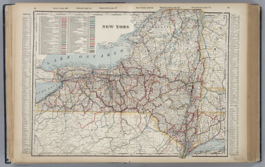
1889 New York. World Atlas Railroad and County Map of New York. Geo … |

1886 New York. World Atlas Colton's New York. (insets) Oswego, Buff … |

1886 New York City, Brooklyn, Jersey City, Ho … World Atlas Colton's New York City, Brooklyn, Jersey … |

1832 Upper Canada, N.Y., Penn., Mich. World Atlas North America sheet III. Upper Canada wi … |

1874 New York. World Atlas Colton's New York. (insets) Oswego; Buff … |

1874 New York City, Brooklyn, Jersey City, Ho … World Atlas Colton's New York City, Brooklyn, Jersey … |

1840 New York. World Atlas New York. Published by the Society for t … |

1866 New York. World Atlas Colton's New York. (insets) Oswego, Buff … |

1866 New York City and the Adjacent Cities. World Atlas G. Woolworth Colton's Map of New York Ci … |

1865 Massachusetts, Rhode Island, and Connect … World Atlas Massachusetts, Rhode Island, and Connect … |

1901 New York, Western Half. World Atlas New York, Western Half. (inset) (Long Is … |

1901 New York, Eastern Half. World Atlas New York, Eastern Half. |

1901 Composite: New York. World Atlas (Composite of) New York. (inset) (Long I … |
1901 New York. World Atlas New York. |

1853 A New Map of New York World Atlas A New Map of New York, with its Canals, … |

1853 City of New York World Atlas City of New York. Entered ... 1850, by T … |

1864 New York (state) World Atlas Johnson's New York By Johnson and Ward. … |

1864 Map of New York (City) and the Adjacent … World Atlas Johnson's Map of New York (City) and the … |

1855 Map of the State of New York World Atlas Map of the State of New York, Compiled f … |

1873 New York. World Atlas New York. (inset) Long Island. |

1873 New York, Pennsylvania, and New Jersey. World Atlas Map of New York, Pennsylvania, and New J … |

1953 Connecticut. Rhode Island. World Atlas Connecticut. Rhode Island. U.S. State. |

1953 New York. World Atlas New York. U.S. State. (insets) (Vicinity … |

1816 New York World Atlas New York. (Engraved by) W. Barker, sculp … |

1870 New York. World Atlas Johnson's New York. (inset) Long Island. … |

1844 New York. World Atlas Neueste Karte von New York mit seinen Ca … |

1844 New-York, Plan von. World Atlas Plan von New-York, 1844. Verlag des Bibl … |

1841 New York. World Atlas New York. Engraved by G.W. Boynton. Ente … |

1841 New York (City). World Atlas New York (City). Engraved by G.W. Boynto … |

1874 New York. World Atlas Johnson's New York. Published by A. J. J … |

1833 New York. World Atlas New York by H.S. Tanner. American Atlas. … |

1848 Canada West (Upper). World Atlas Canada West, formerly Upper Canada. Publ … |

1848 New York. World Atlas A New Map of New York with its Canals, R … |

1848 City Of New York. World Atlas City of New York. Published By S. August … |

1816 New York. World Atlas New York. 16. H.S. Tanner, sc. (1816) |

1872 United States ... North Eastern States. World Atlas United States North America According to … |

1872 Northern Ports & Harbours in the United … World Atlas Northern Ports & Harbours in the United … |

1845 New York. World Atlas New York. (with) Vicinity of the city of … |

1848 New York. World Atlas New York. (with) inset map of Long Islan … |

1848 Map of the Country Twenty Five Miles Rou … World Atlas Map of the Country Twenty Five Miles Rou … |

1822 New York. World Atlas New York. Drawn & Published by F. Lucas … |

1835 New York. World Atlas New York. Drawn & Published by David H. … |

1835 Map of the Country Twenty Five Miles Rou … World Atlas Map of the Country Twenty Five Miles Rou … |

1906 New York. World Atlas New York (West). New York (East). |

1823 New York. World Atlas New York By H.S. Tanner. Engraved & Publ … |

1849 New Map of New York, with its Canals, Ro … World Atlas A New Map of New York, with its Canals, … |

1849 City of New York World Atlas City of New York. Published By S. August … |