Browse All

1874 Sacramento. World Atlas Map of the City of Sacramento, the Capit … |

1874 San Francisco. World Atlas San Francisco. |

1874 Railroad map of Oregon, California, and … World Atlas Gray's Atlas New Railroad and County Map … |

1886 Covers: Johnson's New Illustrated Family … World Atlas (Covers to) Johnson's New Illustrated Fa … |

1897 Gold, silver money and production, natio … World Atlas The world's gold and silver money, 1890. … |

1886 Frontispiece: United States Capitol. World Atlas (Frontispiece to) Johnson's New Illustra … |
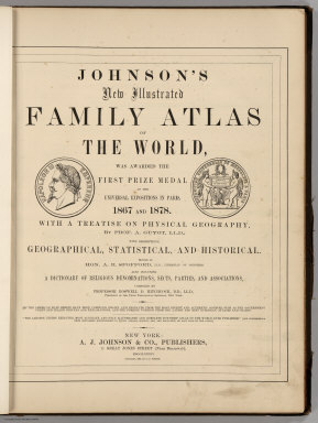
1886 Title Page: Johnson's New Illustrated Fa … World Atlas (Title Page to) Johnson's New Illustrate … |

1897 Turkey In Europe. World Atlas Rand, McNally & Co.'s indexed atlas of t … |

1886 Title Page Verso: Johnson's New Illustra … World Atlas (Title Page Verso to) Johnson's New Illu … |

1886 Table of Contents: Johnson's New Illustr … World Atlas (Table of Contents to) Johnson's New Ill … |

1886 Diagram of difference of time between pl … World Atlas A Diagram Exhibiting the difference of t … |

1886 Johnson's New Chart of National Emblems … World Atlas Johnson's New Chart of National Emblems … |

1886 Comparative Heights of Mountains, and Le … World Atlas Johnson's Chart of Comparative Heights o … |

1886 Principal Mountains, Plateaus, & Plains … World Atlas Johnson's Physical Map Showing the Princ … |

1897 Greece. World Atlas Rand, McNally & Co.'s new 14 x 21 map of … |

1886 Ocean Currents and the Great River Basin … World Atlas Johnson's Ocean Currents and the Great R … |

1886 World, Showing the Circulation of the Wi … World Atlas Johnson's World, Showing the Circulation … |

1886 Forest Trees, Useful Plants, and Mineral … World Atlas Johnson's World, Showing the Distributio … |

1897 Sweden, Norway. World Atlas Rand, McNally & Co.'s new 14 x 21 map of … |

1886 Western Hemisphere. Eastern Hemisphere. World Atlas Johnson's Globular World, Published by A … |

1886 World On Mercator's Projection. World Atlas Johnson's World on Mercator's Projection … |

1886 North America. World Atlas Johnson's North America. Published by Al … |

1886 Ontario. World Atlas Johnson's Ontario of the Dominion of Can … |

1897 Denmark, Iceland. World Atlas Rand, McNally & Co.'s new 11 x 14 map of … |

1886 New Brunswick and Quebec. World Atlas Johnson's New Brunswick and Quebec of th … |

1886 New Brunswick and Nova Scotia. World Atlas Johnson's New Brunswick and Nova Scotia … |

1886 Maine. World Atlas Johnson's Maine. Published by Alvin J. J … |

1886 Vermont And New Hampshire. World Atlas Johnson's Vermont and New Hampshire. Pub … |

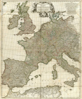
1846 Europe. World Atlas Europe. |

1846 England. World Atlas England. (with) three inset maps: Enviro … |

1846 Scotland. World Atlas Scotland. (with) The Shetland Isles. |

1846 Ireland. World Atlas Ireland. |

1846 France. World Atlas France. (with) two inset maps: Environs … |

1846 Spain and Portugal. World Atlas Spain And Portugal. (with) Environs of M … |

1846 Holland And Belgium. World Atlas Holland And Belgium. |

1846 Germany. World Atlas Germany. |

1846 Sweden & Norway. World Atlas Sweden & Norway. |

1846 Denmark. World Atlas Denmark. |

1846 Prussia. World Atlas Prussia. (with) Environs of Berlin. |

1823 Africa. World Atlas Africa. (with) inset map Supplement of t … |

1823 Egypt. World Atlas Egypt. |

1771 Cover: Atlas general. World Atlas (Covers to) (Atlas general) (Paris : Sr. … |

1771 Index: Atlas general. World Atlas (Index to) (Atlas general) (Paris : Sr. … |
1754 Europe 1. World Atlas Premiere partie de la Carte d'Europe con … |

1758 Europe 2. World Atlas Seconde partie de la carte d'Europe, con … |

1760 Europe 3. World Atlas Troisieme partie de la carte d'Europe, c … |

1751 Asie 1. World Atlas Premiere partie de la carte d'Asie, cont … |

1752 Asie 2. World Atlas Seconde partie de la carte d'Asie, conte … |

1753 Asie 3. World Atlas Troisieme partie de la carte d'Asie, con … |

1749 Afrique nord. World Atlas Afrique. (Northern section). Publiee sou … |