Browse All

1824 The Seven United Provinces of Holland, G … World Atlas The Seven United Provinces of Holland, G … |

1824 Sweden, Denmark, Norway, and Finland fro … World Atlas Sweden, Denmark, Norway, and Finland fro … |

1824 Map of the Country belonging to the Cher … World Atlas Map of the Country belonging to the Cher … |

1824 Quebec and Adjacent Country ... during t … World Atlas Plan of Quebec and Adjacent Country Shew … |

1824 East End of Lake Ontario and River St. L … World Atlas East End of Lake Ontario and River St. L … |

1824 St. Lawrence and Adjacent Country. World Atlas Map of the St. Lawrence and Adjacent Cou … |

1824 Chart of the Atlantic Ocean. World Atlas Chart of the Atlantic Ocean. John Melish … |

1824 Countries Situated between Shiraz and Co … World Atlas Sketch of the Countries Situated between … |

1824 Sketch of the Action on the Heights of C … World Atlas Sketch of the Action on the Heights of C … |

1824 Bonaparte's Route from Elba to Paris. World Atlas Bonaparte's Route from Elba to Paris, Fr … |

1790 Cover: General atlas. World Atlas (Covers to) A general atlas, describing … |

1790 Title Page: General atlas. World Atlas (Title Page to) A general atlas, describ … |

1787 A general map of the world or terraqueou … World Atlas A general map of the world or terraqueou … |
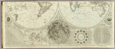
1787 A general map of the world or terraqueou … World Atlas (A general map of the world or terraqueo … |

1787 Composite: World or terraqueous globe. World Atlas (Composite of) A general map of the worl … |

1787 Europe divided into its empires, kingdom … World Atlas Europe divided into its empires, kingdom … |

1787 (Europe divided into its empires, kingdo … World Atlas (Europe divided into its empires, kingdo … |

1787 Composite: Europe. World Atlas (Composite of) Europe divided into its e … |

1788 A compleat map of the British Isles. World Atlas A compleat map of the British Isles, or … |

1790 England and Wales (Northern section) World Atlas England and Wales, drawn from the most a … |

1790 England and Wales (Southern section) World Atlas (England and Wales, drawn from the most … |

1790 Composite: England, Wales. World Atlas (Composite of) England and Wales, drawn … |

1790 A new and correct map of Scotland or Nor … World Atlas A new and correct map of Scotland or Nor … |
1837 Geographiques de Ptolemee, de Strabon & … World Atlas Systemes Geographiques de Ptolemee, de S … |

1837 Empire d'Alexandre. World Atlas Empire d'Alexandre. No. 5. Longitude du … |

1837 Monde connu des anciens. World Atlas Monde Connu des Anciens, au IIe Siecle d … |

1872 Islands of Japan. World Atlas Islands of Japan. (with) Japan, Mandshur … |

1837 Europe Ancienne. World Atlas Europe Ancienne, 1831. No. 7. Longitude … |

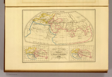
1837 Asie Ancienne. World Atlas Asie Ancienne, 1831. No. 8. Longitude du … |

1837 Asie Mineure ancienne. World Atlas Asie Mineure Ancienne, 1831. No. 8, bis. … |

1837 Afrique Ancienne. World Atlas Afrique Ancienne. No. 9. Longitude du Me … |

1837 Palestine, Royaume des Israelites, Les D … World Atlas Palestine, Royaume des Israelites sous D … |

1837 Egypte Ancienne. World Atlas Egypte Ancienne. No. 11. Longitude du Me … |

1837 Grece Ancienne au Commencement de l'Ere … World Atlas Grece Ancienne au Commencement de l'Ere … |

1837 Italie ancienne. World Atlas Italie Ancienne. No. 13. Longitude du Me … |

1837 Espagne ancienne. World Atlas Espagne Ancienne. No. 15. Grave par Thie … |

1837 Carte des Gaules. World Atlas Carte des Gaules, Divisee en Provinces R … |

1872 Indian Archipelago. World Atlas Indian Archipelago Compiled From The Var … |

1837 Empire Romain sous Constantin et sous Tr … World Atlas Empire Romain sous Constantin et sous Tr … |

1837 Table Theodosienne Dite Carte de Peuting … World Atlas Table Theodosienne Dite Carte de Peuting … |

1837 Europe apres l'Invasion des Barbares. World Atlas Europe apres l'Invasion des Barbares au … |

1837 Europe en 1100. World Atlas Europe en 1100 indiquant la date de la F … |

1837 Geographie du Moyen Age. World Atlas Geographie du Moyen Age, Principalement … |

1837 Empire des Mongols. World Atlas Empire des Mongols. No. 20. Grave par Th … |

1837 Carte Geologique d'Europe. World Atlas Carte Geologique d'Europe. Dressee par J … |

1837 Carte Physique et Mineralogique des Isle … World Atlas Carte Physique et Mineralogique des Isle … |

1837 Carte Physique et Mineralogique de la Fr … World Atlas Carte Physique et Mineralogique de la Fr … |

1837 Coupes Geologiques entre Paris et Colmar … World Atlas Coupes Geologiques. Coupe des terraines … |

1872 Oceania, or Islands in the Pacific Ocean … World Atlas Oceania, or Islands in the Pacific Ocean … |

1837 Mappe-monde. World Atlas Mappe-Monde, Suivant la Projection de Me … |