Browse All

1736 Greece or the south part of Turky in Eur … World Atlas Greece or the south part of Turky in Eur … |

1736 Asia. World Atlas Asia By H. Moll Geographer. (Printed and … |

1736 Caspian Sea, Terky, Derbent, Astracan. World Atlas The Caspian Sea. Drawn by the Czar's Spe … |

1736 Great Tartary. World Atlas Great Tartary. With the tract of the Mos … |

1736 Turkey in Asia; or Asia Minor &c. World Atlas Turkey in Asia; or Asia Minor &c. Agreea … |

1736 Arabia. World Atlas Arabia. Agreeable to modern history. By … |

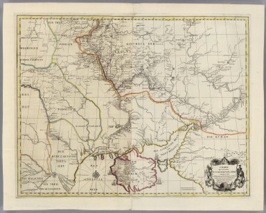
1736 Persia, Caspian Sea, part of Independent … World Atlas Persia, the Caspian Sea done by ye Czar, … |

1736 India Proper or the Empire of the Mogul. World Atlas India Proper or the Empire of the Mogul. … |

1736 Empire of China, island of Japan. World Atlas The Empire of China and island of Japan, … |

1736 Map of the continent of the East-Indies … World Atlas A map of the continent of the East-Indie … |

1736 Prinicipal islands of the East-Indies. World Atlas The prinicipal islands of the East-Indie … |

1736 Africa. World Atlas Africa. By H. Moll Geographer. (Printed … |

1736 West and east parts of Barbary. World Atlas The west part of Barbary containing Fez, … |

1736 Negroland and Guinea. World Atlas Negroland and Guinea, with the European … |

1736 St. Helena; Bay of Agoa de Saldanha. World Atlas St. Helena ... By H. Moll Geographer. Th … |

1736 South part of Africa and Magadascar. World Atlas The south part of Africa, and the island … |

1736 America. World Atlas America. By H. Moll Geographer. (Printed … |

1736 New map of ye north parts of America. World Atlas A new map of ye north parts of America, … |

1736 New Found Land, St. Laurence Bay, Acadia … World Atlas New Found Land, St. Laurence Bay, the fi … |

1736 Bay of Fundy and harbour of Annapolis Ro … World Atlas A description of the Bay of Fundy shewin … |

1736 New England, New York, New Jersey and Pe … World Atlas New England, New York, New Jersey and Pe … |

1736 Virginia and Maryland. World Atlas Virginia and Maryland. By H. Moll, Geogr … |

1736 Carolina. World Atlas Carolina by H. Moll, Geographer. (Printe … |

1736 Plan of Port Royal Harbour in Carolina. World Atlas A plan of Port Royal Harbour in Carolina … |

1736 Island of Bermudos, Part of Providence I … World Atlas The island of Bermudos. Divided into its … |

1736 Florida called by ye French Louisiana &c … World Atlas Florida called by ye French Louisiana &c … |

1736 Map of the West-Indies, Mexico or New Sp … World Atlas A map of the West-Indies &c., Mexico or … |

1736 Island of Jamaica. World Atlas The island of Jamaica divided into its p … |

1736 Island of St. Christophers, alias St. Ki … World Atlas The island of St. Christophers, alias St … |

1736 Island of Antego. World Atlas The island of Antego. By H. Moll Geograp … |

1736 Island of Barbadoes World Atlas The island of Barbadoes. Divided into it … |

1736 Scots settlement in America, New Caledon … World Atlas The Scots settlement in America called N … |

1736 Map of Terra Firma, Peru, Amazone-Land, … World Atlas A map of Terra Firma, Peru, Amazone-Land … |

1736 Map of Chili, Patagonia, La Plata, part … World Atlas A map of Chili, Patagonia, La Plata and … |

1736 Charte der Kriegsoperationen am Donn und … National Atlas Charte der Kriegs Operationen am Donn un … |
1736 Charte derer von der Russisch-Keyser Arm … National Atlas Charte derer von der Russisch-Keyser Arm … |