Who What Where WhenREMOVEWHATShow More |
Author
Robert Laurie & James Whittle
Full Title
A new and correct map of the British colonies in North America. Comprehending Eastern Canada with the province of Quebec, New Brunswick, Nova Scotia, and the government of Newfoundland; with the adjacent states of New England, Vermont, New York, Pennsylvania and New Jersey. London, Publish'd by Laurie & Whittle, 53 Fleet Street, 12th May, 1794.
Publisher
Laurie & Whittle
Author
Robert Laurie & James Whittle
Full Title
A new and general map of the middle dominions belonging to the United States of America, viz. Virginia, Maryland, the Delaware-Counties, Pennsylvania, New Jersey &c., with the addition of New York, & of the greatest part of New England &c., as also of the bordering parts of the British possessions in Canada. (with) A sketch of the upper parts to shown the remainder of the lakes. London, Published by Laurie & Whittle, No. 53, Fleet Street, as the act directs 12th May, 1794.
Publisher
Laurie & Whittle
Author
Robert Laurie & James Whittle
Full Title
A new and general map of the southern dominions belonging to the United States of America, viz: North Carolina, South Carolina, and Georgia: with the bordering Indian countries, and the Spanish possessions of Louisiana and Florida. (with) Plan of Charlestown. (with) Plan of St. Augustine. London, Published by Laurie & Whittle, No. 53, Fleet Street, as the act directs 12th May, 1794.
Publisher
Laurie & Whittle
Full Title
(A map of South America containing Tierra-Firma, Guayana, New Granada, Amazonia, Brasil, Peru, Paraguay, Chaco, Tucuman, Chili and Patagonia, from Mr. d'Anville with several improvements and additions, and the newest discoveries. North half. (with) A chart of Falkland's Islands named by the French Malouine Islands and discovered by Hawkins, in the year 1593. London, Published by Laurie & Whittle, No. 53 Fleet Street, as the act directs 12th May, 1794)
Publisher
Laurie & Whittle
Author
[Anville, Jean Baptiste Bourguignon d, 1697-1782, Robert Laurie & James Whittle]
Full Title
A map of South America containing Tierra-Firma, Guayana, New Granada, Amazonia, Brasil, Peru, Paraguay, Chaco, Tucuman, Chili and Patagonia, from Mr. d'Anville with several improvements and additions, and the newest discoveries. (South half). London, Published by Laurie & Whittle, No. 53 Fleet Street, as the act directs 12th May, 1794.
Publisher
Laurie & Whittle
Author
[Anville, Jean Baptiste Bourguignon d, 1697-1782, Robert Laurie & James Whittle]
Full Title
(Composite of) A map of South America containing Tierra-Firma, Guayana, New Granada, Amazonia, Brasil, Peru, Paraguay, Chaco, Tucuman, Chili and Patagonia, from Mr. d'Anville with several improvements and additions, and the newest discoveries. (with) A chart of Falkland's Islands named by the French Malouine Islands and discovered by Hawkins, in the year 1593. London, Published by Laurie & Whittle, No. 53 Fleet Street, as the act directs 12th May, 1794.
Publisher
Laurie & Whittle
Author
Carey, Mathew
Full Title
The British Possessions in North America from the best Authorities by Samuel Lewis 1794. (with) inset of of Hudson's and Baffin's Bays. Engraved for Carey's American Edition of Guthrie's Geography improved.
Publisher
Mathew Carey
Author
Carey, Mathew
Full Title
The State of New Hampshire. Compiled chiefly from Actual Surveys. By Samuel Lewis, 1794.
Publisher
Mathew Carey
Author
Carey, Mathew
Full Title
The Province of Maine, From the best Authorities by Samuel Lewis, 1794. Engraved for Carey's American Edition of Guthrie's Geography improved.
Publisher
Mathew Carey
Author
Rizzi Zannoni, Giovanni Antonio (1736-1814)
Full Title
No. 14. (Napoli, Ischia, Procida, Capri, Salerno). Gius. Guerra inc. Nap. 1794. (to accompany) Atlante geografico del regno di Napoli 1808.
Publisher
Giuseppe Guerra
Author
[Delarochette, Louis Stanislas d'Arcy, Dicquemare, Abbe (Jacques Francois), 1733-1789, Faden, William, 1750?-1836]
Full Title
A chart of the British Channel and the Bay of Biscay, with a part of the North Sea, and the entrance of St. George's Channel. By Monsr. L. Abbe Diquemare (i.e. Dicquemare), with several emendations, and many useful additions &c. by L.S. De la Rochette. 3d. edition, MDCCXCIV. London, engraved & published as the Act directs by W. Faden, succr. to the late T. Jefferys, Geogr. to the King. Charing Cross, Sept. 17th, 1794.
Publisher
William Faden
Author
Faden, William, 1750?-1836
Full Title
A map of the Seven United Provinces with the Land of Drent, and the Generality Lands. By W. Faden, Geographer to the King, MDCCLXXXIX. 2d edition. London, published by W. Faden, Charing Cross, July 1st, 1794.
Publisher
William Faden
Author
[Delarochette, Louis Stanislas d'Arcy, Faden, William, 1750?-1836]
Full Title
Scandia or Scandinavia, comprehending Sweden and Norway, with the Danish islands; to which is added the remainder of the possessions of Denmark. By L.S. Delarochette. London: published by Wm. Faden, Geographer to the King, and to His R.H. the Prince of Wales, February 10th, 1794. Wm. Palmer sculp.
Publisher
William Faden
Author
Anville, Jean Baptiste Bourguignon d, 1697-1782
Full Title
A new map of Turkey in Asia by Monsr. d'Anville, first geographer to the most Christian King with several additions. London, published by Laurie & Whittle, no. 53 Fleet Street as the Act directs, 12th May, 1794.
Publisher
William Faden
Author
Wilkinson, Robert
Full Title
The Circle of Upper Saxony with the Marquistate of Lusatia.
Publisher
Robert Wilkinson
Author
Wilkinson, Robert
Full Title
Circle of Wesphalia.
Publisher
Robert Wilkinson
Author
Wilkinson, Robert
Full Title
A New Map of the Dominions of the King of Sardinia with Part of the Estates of Genoa. (inset) The Island of Sardinia.
Publisher
Robert Wilkinson
Author
Wilkinson, Robert
Full Title
A New Map of Great Britain and Ireland.
Publisher
R. Wilkerson
Author
Wilkinson, Robert
Full Title
A New and Accurate Map of Scotland.
Publisher
R. Wilkerson
Author
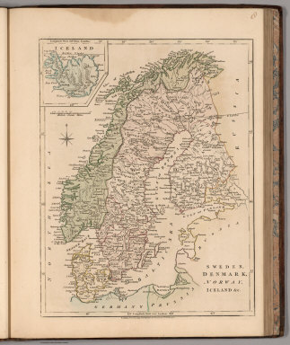
Wilkinson, Robert
Full Title
Sweden, Denmark, Norway, Iceland &c.
Publisher
R. Wilkerson
Author
Wilkinson, Robert
Full Title
The Circle of Upper Saxony with the Marquistate of Lusatia.
Publisher
R. Wilkerson
Author
Wilkinson, Robert
Full Title
The Circle of Lower Saxony.
Publisher
R. Wilkerson
Author
Wilkinson, Robert
Full Title
Circle of Wesphalia.
Publisher
R. Wilkerson
Author
Wilkinson, Robert
Full Title
A Map of the Circle of Austria.
Publisher
R. Wilkerson
Author
Wilkinson, Robert
Full Title
A Map of the Dutchy of Silesia.
Publisher
R. Wilkerson
Author
Wilkinson, Robert
Full Title
Hungary and Transilvania.
Publisher
R. Wilkerson
Author
Wilkinson, Robert
Full Title
Spain and Portugal.
Publisher
R. Wilkerson
Author
Wilkinson, Robert
Full Title
Switzerland with its Subjects & Allies.
Publisher
R. Wilkerson
Author
Wilkinson, Robert
Full Title
A New Map of the Dominions of the King of Sardinia with Part of the Estates of Genoa. (inset) The Island of Sardinia.
Publisher
R. Wilkerson
Author
Wilkinson, Robert
Full Title
The North East Part of Italy Comprising the Estates of Venice.
Publisher
R. Wilkerson
Author
Wilkinson, Robert
Full Title
Turkey in Asia.
Publisher
R. Wilkerson
Author
Wilkinson, Robert
Full Title
A New Accurate Map of New South Wales with Norfolk and Lord Howes Islands Port Jackson, &c.
Publisher
R. Wilkerson
Author
Wilkinson, Robert
Full Title
North America.
Publisher
R. Wilkerson
Author
Wilkinson, Robert
Full Title
An Accurate Map of the West Indies.
Publisher
R. Wilkerson
Author
Wilkinson, Robert
Full Title
A New Map of South America.
Publisher
R. Wilkerson
Author
Chollet, L.
Full Title
Chollet - 1794. S Doc 91 55 2. 69. Map of the Pomeroon Coast Region, Surveyed for the Dutch Government by the Colonial Surveyors van de Burght and Chollet, and Charted by the Latter, 1794. Reproduced from the Autograph Original in the Rijksarchief at the Hague, (No. 1545 of Catalogue). Photo. Lith. by A. Hoen & Co., Baltimore, MD.
Publisher
United States of America
|