Browse All

1805 [An Engraving From Hayley's 'ballads: Th |

1805 [A Milkmaid Milking A Cow, PA-F07008-003 Peter le Cave |

1805 [The Morolist, PA-F04556-0009: The Morol John Raphael Smith |

1805 [Mrs Danby, PA-F04555-0065: Mrs Danby] John Raphael Smith |

1805 [An Engraving From Hayley's 'ballads: Th |

1805 [Bearing The Dead Body Of Patroclus To T Douglas Guest |

1805 [The Angel Of The Revelation, PA-F08121- William Blake |

1805 [A Mountainous Wooded Landscape With Wag George Arnald Baker |

1805 [A House Among Trees, PA-F05792-0007: A John Varley |

1805 [A View Of Westminster From Southbank Lo William Anderson |

1805 [The Grace Adorning Venus, PA-F08244-022 John Constable |

1805 [An Engraving From Hayley's 'ballads: Th |

1805 [The Stour Valley, PA-F08244-0233: The S John Constable |

1805 [Banditti With Prisoners, PA-F04876-0017 John Hamilton Mortimer |

1805 [The Interior Of A Barn, PA-F06277-0013: John Sell Cotman |

1805 [Sir Charles Warre Malet, Bt. The Britis Thomas Daniell |

1805 [Henry Pearce, The Game Chicken, PA-F053 William Armfield Hobday |

1805 [Portrait Of Samuel Athawes, PA-F04555-0 John Raphael Smith |
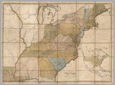
1805 Map of the United States. Case Map Map of the United States, Exhibiting the … |

1805 Covers: Map of the United States. Case Map (Covers to) Map of the United States, Ex … |

1805 Nord America Separate Map Nord America mit Benuzung der neuesten u … |

1805 Map of The Island of Ceylon Separate Map Map of The Island of Ceylon Drawn by A. … |

1805 England and Wales. World Atlas England and Wales. |

1805 France Divided into Provinces. World Atlas France Divided into Provinces. |

1805 France Divided into Departments. World Atlas France Divided into Departments. |

1805 Africa. World Atlas A new map of Africa, from the latest aut … |

1805 Egypt. World Atlas A new map of Egypt, from the latest auth … |

1805 Western Terr., Kentucky, Pennsylvania, e … World Atlas A new map of part of the United States o … |

1805 France. World Atlas France Divided into Provinces. |

1805 France. World Atlas France Divided into Departments. |

1806 Covers: Wilkinson's General Atlas of the … World Atlas (Covers to) Wilkinson's General Atlas of … |

1806 Title Page: Wilkinson's General Atlas of … World Atlas (Title Page) Wilkinson's General Atlas o … |

1806 Text: Geography. World Atlas (Text Page) Geography. |

1806 Table of Contents: Contents ... 1805. World Atlas (Table of Contents) Contents ... 1805. |

1800 World. World Atlas The World from the Discoveries & Observa … |

1800 Mercators Chart. World Atlas A New Mercator's Chart Drawn from the La … |

1802 Europe. World Atlas Europe. |

1794 A New Map of Great Britain and Ireland. World Atlas A New Map of Great Britain and Ireland. |

1794 A New and Accurate Map of Scotland. World Atlas A New and Accurate Map of Scotland. |

1806 Ireland. World Atlas Ireland as Represented in the Imperial P … |
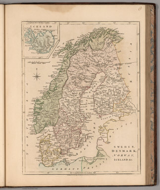
1794 Sweden, Denmark, Norway, Iceland &c. World Atlas Sweden, Denmark, Norway, Iceland &c. |

1800 A New Map of Denmark and Holstein. World Atlas A New Map of Denmark and Holstein. |

1801 The Russian Empire in Europe and Asia. World Atlas The Russian Empire in Europe and Asia. |

1799 Russia in Europe. World Atlas Russia in Europe with the Dismemberments … |

1799 Poland World Atlas Poland, with its Dismembered Provinces, … |

1791 A New Map of Prussia. World Atlas A New Map of Prussia. |

1791 Germany. World Atlas A New Map of Germany divided into Circle … |

1794 Upper Saxony with the Marquistate of Lus … World Atlas The Circle of Upper Saxony with the Marq … |

1794 Lower Saxony. World Atlas The Circle of Lower Saxony. |

1794 Wesphalia. World Atlas Circle of Wesphalia. |